2/24/2018 - Sand Cave Hollow polyfoss
GPS Coordinates: (Latitude, Longitude, Elevation)
Parking Location (Waterfalls): 35.54853 -92.89040, 1373 ft
Parking Location (Sand Cave): 35.54491 -92.90199, 1100 ft
Sand Cave: 35.54430, -92.90148, 1059 ft
Falls #1: 35.54135 -92.90110, 881 ft.
Falls #2: 35.54208 -92.89472, 1032 ft.
Sand Cave Falls: 35.54114 -92.89268, 1126 ft.
Falls #4: 35.54131 -92.89254, 1142 ft.
Sand Cave Quintuple Falls: 35.54121 -92.89229, 1202 ft.
Falls #10: 35.54677 -92.89185, 1195 ft.
Falls #11: 35.54173 -92.89254, ll543 ft.
Falls #12: 35.54157 -92.89266
Falls #13: 35.54138 -92.89294, 1032 ft.
Pet-Friendly: Dogs off leash should be okay. Dogs on leash will make it difficult to access many of these areas, but could be done. Note that it is fairly steep getting down into and out of the grotto for Sand Cave Hollow Falls.
Motorcycle Friendly: No. Parking is off Lindsey Mountain Motorway. This is a not-so-good dirt road many miles down other dirt roads. Not recommended for street bikes and cruisers.
Hiking Statistics: From top to bottom, the Blue Hole SIA is about 1000 feet of elevation change. Today, we hiked 1.85 miles with a highest to lowest elevation change of only 385 feet. This was all bushwhacking, although there is an old trace road we could follow most of the way. Overall I would call this a moderate bushwhack. We were hiking for 2 hours and 8 minutes on the track at the bottom of this post.
GPS files (.gpx format) - Maps of the GPS track are at the bottom of this post.
 |
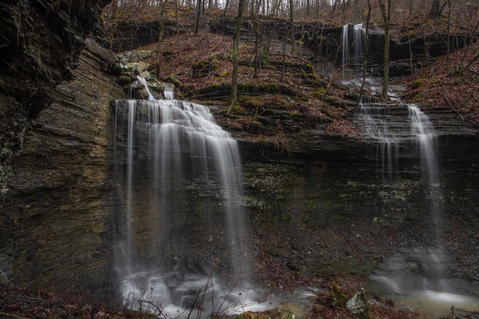
| Sand Cave Hollow Falls |
When we visited Sand Cave Hollow for the first time in March of 2017, we found a pretty spectacular area in the upper end of the hollow. After almost giving up on finding anything, we found the beautiful waterfall we named Sand Cave Hollow Falls, then six more waterfalls above it, including five so close together I just called them Quintuple Falls as a group. This was another of those areas we vowed to come back to, so we could see them after things "greened up" a bit, and hopefully with more water flowing in the creek. Well, we did, a couple of months later when it was fairly wet and there was foliage on the trees. Unfortunately, we learned another lesson. Not only do you need wet weather to see this polyfoss in all it's glory, if the trees are all "greened up", you can see it by moving around but your camera can't see many of the waterfalls from the same spot because of the foliage. So, back on the "wet weather go-to" list it went. Today, after some heavy rains this week, we decided to give it another shot, hoping to get in and out of the area between rains. My hiking companions today were Dan Frew and David Dedman.
 |
| Falls #11 |
To get there, drive north from Hector on Highway 27. Less than a mile from the Big Piney Ranger station in Hector, you cross over Dare Creek. Immediately after crossing Dare Creek, turn right onto White Oak Mountain Road (aka FR-1301). This is a gravel road but is a well traveled and fairly well-maintained road. Go 11.4 miles on White Oak Mountain Road. Be careful 7.2 miles from Highway 27 and bear left where the road branches at the 'Y' in the road. After following White Oak Mountain Road for 11.4 miles, turn left onto Lindsey Mountain Motorway. Go 2.9 miles and park on the left.
 |
| Quintuple Falls |
One of the reasons I decided to write this blog was to keep track of my various explorations and learn from them. Ideally, every time I go to an area I will find something that will help me the next time I visit the area. This blog also helps me pass that information on to others. On our first hike in Sand Cave Hollow, I noted that the waterfalls that were worth the trek were all in the upper part of the hollow, and that we could get to that area directly from Lindsey Mountain Motorway fairly easily. We also noted that we could park at a point on Lindsey Mountain Motorway at about the same elevation as the polyfoss, eliminating a climb in elevation at the end. When we tried that, we learned another lesson; the brush is really dense along the road at that elevation, but not along the road higher up, a half mile to the east. The parking location noted above will have an additional climb of about a hundred feet, but is a much easier hike.
 |
| Falls #10 |
Today, I think we had the lay of the land all figured out and it turned out to be an optimal way in and out of this fantastic concentration of waterfalls. We started out heading directly to Falls #10 and hit the old trace road that goes along the top of the drainages, then followed it to the top of the north prong in Sand Hollow. Falls #10 is just below the old road, a short detour and very small climb into and out of the upper part of this prong. The water flow was the best I had seen in three visits here, and it was definitely "photo-worthy". We took some photos, got back on the old trace road, and continued around the east end of Sand Cave Hollow.
 |
| Falls #13 |
The old trace road has some minor undergrowth and downed trees, but is still much easier hiking than trekking through the woods. It goes mostly on the level around the hollow and into the east prong, where the polyfoss is. Just before getting there, we crossed another drainage that only had a trickle in it on previous visits, but today had a good amount of flow and three additional waterfalls. The lowest of these, Falls #13, is over 20 feet tall and spills into the main creek very close to the base of Sand Cave Hollow Falls. We went from Falls #11 to Falls #12, then down all the way to the creek. The break to get down to the creek below Falls #13 is very steep, but do-able. Other than hiking the creek all the way from the outlet, which we certainly did not want to do, this was the only way to get into and out of the grotto with Falls #13 and Sand Cave Hollow Falls.
 |
| Falls #4 (foreground) |
Sand Cave Hollow Falls was really gushing today. With water hitting the grotto from multiple waterfalls, it was creating quite a mist and I had a hard time keeping the camera lens dry. From Sand Cave Hollow Falls, we climbed up the steep access just downstream of Falls #13, then over across the drainage at the top of Falls #13, and upstream a few yards to Falls #4, yet another really nice waterfall. The climb above Falls #4 is easier, and that puts you right at the base level for the lower tier of Sand Cave Quintuple Falls. There is one "full height" waterfall on the left, then in the center and right side there are two tiers of waterfalls, making five in total. It is truely a spectacular sight, one I highly recommend you experience in person.
 |
| Quintuple Falls |
While all five are grouped together here, and make a stunning visual for the human eye, my camera's eye is not nearly that good. Dan and David both had wider angle lens than I did, but even with that, I don't think any camera can fully convey the sights and sounds of this area. We spent quite a bit of time in the Quintuple Falls area, taking photos and videos, all of which look great. That being said, it is one of those areas that you really need to go to for the full experience. I will be getting an 11mm Tokina lens for my D500, but believe me, it still won't convey how fantastic this area is.
 |
| Quintuple Falls |
We finally got our fill of the Quintuple Falls experience and headed back. From the leftmost of the Quintuple Falls (the single tier one), you can follow the base of the bluff at the bottom of the waterfall up and around to the left to climb to the top of the bluff. This is the level that old trace road runs at, and we soon came to it and started hiking back the way we came. As you can see from the map below, we did veer off the old road before getting to Falls #10. There was very little undergrowth bushwhacking back this way, and the slope was much lower, providing a gradual climb back up to the elevation of Lindsay Mountain Motorway. As I mentioned before, I think we have our route for this hike wired now. Despite some occasional steep and slippery parts such as getting to the base of Sand Cave Hollow Falls, it is not that difficult as bushwhacks go. I would rate it as a moderate bushwhack. Even though I have seen this three times now, I'm certain I'll be back to show friends this spot.
 |
Sand Cave Hollow
Red - 3-17-2017 GPS track of entire hollow
Blue - 2-23-2018 GPS track to polyfoss area only |


The thing about falls...every hollow has some.
ReplyDeleteYep, in the Ozarks, anyway. All somewhat different, I like them all.
Delete