Tuesday, December 13, 2016

Arkansas Sphinx, between Hagerville and Sand Gap, Arkansas Ozarks

12/13/2016 - Arkansas Sphinx

GPS Coordinates: (Latitude, Longitude, Elevation)  
  Parking Location #1:  35.63916   -93.29101
  Parking Location #2:  35.65107   -93.29597
  Small bluffline break:  35.64045   -93.29036
  Arkansas Sphinx:  35.64059   -93.28896,  1715 ft.

Pet Friendly: Dogs on or off leash should be OK. 

Motorcycle Friendly:  Yes. Parking location #2 is right on Highway 123, and there is a nice flat parking space at the junction of CR-5741 to park at, across the highway from the trail you will be taking.  Parking location #1 is a little over a half mile down a not-so-good dirt road, but easily doable on your big bike for the short distance.

Hiking Statistics: There are three segments of today's hike, and most folks will only need one of them so I will detail each separately:
 - Route #1 to the Arkansas Sphinx is only 0.17 miles (945 feet) long, with an elevation gain of 350 feet.
 - Route #2 to the Arkansas Spinx is 1.27 miles, with an elevation gain of 638 feet.  There is one section of trail near the base of the knob that goes downhill slightly, then back uphill.
 - If you take one route in and the other out, as I did today, the road distance between the two parking locations is 1.15 miles, with a highest-to-lowest distance of 191 feet.  It does go downhill from parking location #1 to Highway 123, and slightly uphill on Highway 123 to parking location #2.

GPS files (.gpx format) - maps with GPS tracks are at the bottom of this post
  GPS track for route #1 to Arkansas Sphinx
  GPS track for route #2 to Arkansas Sphinx

The Arkansas Sphinx
Since there is no water in the creeks for the waterfalls, I went another direction today.  There are many nice hikes in the Ozarks to places that don't need water to be an attraction, and today I just wanted to get out in the woods.  I had recently seen a rerun episode of Exploring Arkansas that featured the rock formation known as the Arkansas Sphinx.  Then, last week, I went to a slide show presented by Tim Ernst and noticed that one of his new photo books had the Arkansas Sphinx on the cover.  To top it off, I got a copy of Danny Hale's new hiking guidebook in the mail a couple of days ago, and when I cracked it open it was on the page for the Arkansas Sphinx.  I can take a hint.  Clearly, the Cosmos wanted me to go to the Sphinx, and who am I to argue with fate?  To top it off, my friend and frequent hiking partner, Dan Frew, was the guy that found this hunk of rock many years ago and dubbed it the Arkansas Sphinx.  Not wanting to tempt the wrath of The Cosmos, I packed up and headed out.  Bethany was taking Boomer to the vet to look at an injured leg, so I was on my own today.

Parking Location #2
To get to the parking location, the driving directions are pretty simple.   
  - For Parking Location #2, from the community of Pelsor (Sand Gap), go 16.2 miles south on Highway 123, then turn left onto an old road with a gate opposite the junction with Johnson County CR-5741.  This is 3.3 miles past the Haw Creek Campground.  If you are coming from the other direction on Highway 123, this junction is 10.5 miles north of Hagerville.
  - For Parking Location #1, go 0.6 miles south on Highway 123 from Parking Location #2, and turn onto CR-4840.  Go another 0.6 miles on CR-4840, and you are at Parking Location #1.


The Arkansas Sphinx
There are a couple of routes to the Arkansas Sphinx.  If you just want to go see it and cross it off your bucket list, I would recommend what I call route #1.  It is the most direct, and definitely the shortest.  Route #2 is not long, 1.3 miles, but route #1 is much shorter at only 0.17 miles.  Both routes are very steep as you go up near the top of Hess Knob that the Arkansas Sphinx sits on.  Route #2 also climbs almost twice as much, altitude-wise, as route #1, but the first part is spread out over almost a mile of trail.  Today, I wanted to get at least a moderate hike, so I went on route #2 for the hike in.  Because I prefer to see as much different scenery as possible, I hiked back out on route #1, then hiked along the road from parking location #1 to parking location #2.


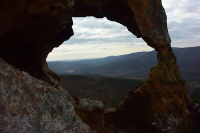
Spectacular views - through the eye of the Sphinx
From parking location #2, you hike along an old logging road up to a food plot at about 0.7 miles in.  This old road is in decent shape and would be easily drivable with a good 4WD vehicle, but is always blocked off by the forest service.  They go in occasionally and bush-hog the food plot and road, but that's about all the maintenance it gets.  In any case, I have never seen the gate open on it, but it does make for an easy hiking trail.  Going out the other end of the food plot, the old road is more of an ATV trail but still makes for easy hiking.  You can take this ATV trail up all the way to the top of the knob.  When you get toward the base of the top part of the knob, there is a dense thicket growth in front of you, and the ATV trail makes a hard left turn.  Stay on the ATV trail, and it winds around the base a short distance, dipping down and then turning up the mountain, taking you all the way to the top.  I saw no recent signs of ATV traffic, but it was in fairly good shape for hiking.  


Arkansas Sphinx
Just stay on this ATV trail and you will be okay.  The trail takes you to the top of the knob, and from there you can see the Arkansas Sphinx on the slope on the other side of the mountain.  This route takes you higher up on the mountain, called Hess Knob, and from here you can see forever.   Hess Knob juts up to an elevation of almost 2000 feet, and you can see quite a distance in all directions.  The views are quite spectacular, and if you climb up to the Sphinx by route #1, you should climb the additional 200 feet or so to check out the scenery.  The Arkansas Sphinx itself is just a big chunk of sandstone, but it's a pretty awesome looking rock.  I'm no geologist, but I assume this is all that remains of a large sandstone layer, everything else having eroded away over time.  There are a couple of holes through it, one in the "tail", and one running through the north-south mid-section.  To be honest, I think it looks as much like a duck as it does The Sphinx, but "Arkansas Sphinx" has a much more impressive ring than "Arkansas Duck Rock".  So, good choice of names all those years ago, Dan.


Parking Location #1
Note the two trees with an "S" marking the trail.
After spending a good deal of time taking in the views and climbing on the Arkansas Sphinx, I headed back.  This time, I took route #1.  There is a pretty good volunteer trail going straight downhill from the Sphinx, and it is visible enough this time of year to easily follow it.  When the trail goes over a small bluffline below the Arkansas Sphinx, it zigzags down a small break along the bluff.  I think this route is somewhat steeper, but it's also for a much shorter distance.  When the trail starts off from the road, it is not quite as visible as it is higher up, but someone has helped you out by marking some trees.  At parking location #1, there is a big white "S" spray painted on a tree.  The trail goes around this tree on the left, then breaks right and goes to another big tree with an "S", and swings left around this second tree.  After that, it is very visible and easy to follow.  One word of caution; on the lower part of this route, it is thick with 'Devil's Walking Sticks' on both sides of the trail.  If you are not familiar with these small trees/bushes, they are indeed the work of the devil.  They have very sharp thorns on the trunks and branches and will poke right through heavy gloves.  Just be aware they are there and don't grab any small trees for support.

After coming down the trail to parking location #1, I hiked along CR-4840 and then back up Highway 123 to where I had parked the FJ Cruiser at parking location #2.  Even with this additional distance, I only hiked a total of 2.7 miles.  I would rate this as a moderate hike only due to the steepness of the trail, no matter which route you take to get there.  The trails in both routes are in fairly good condition, so hikers of all ages should be able to do this hike if they can make the climb.  
Blue - Route #1 to Arkansas Sphinx
Red - Route #2 to Arkansas Sphinx


Friday, December 9, 2016

Devon Falls, Hamilton Falls, Twin Falls, and Richland Falls, Richland Wilderness area, Ozarks near Lurton, Arkansas

12/7/2016 - Twin Falls, Devon Falls, Richland Falls, Hamilton Falls

GPS Coordinates:  (Latitude, Longitude, Elevation)
  Parking and Trail Head:  35.80737,  -92.93940,  1516 ft.
  Twin Falls: 35.80594, -92.96412,  1184 ft.
  Richland Falls: 35.80075, -92.96010,  1155 ft.
  Jim Bob (Long Devil's) Falls:  35.80804,  -92.96831,  1316 ft.
  Devon Falls:  35.81724,  -92.96145,  1435 ft.
  Don Hamilton Falls:  35.81199, -92.96375,  1320 ft.
  Big Devil's Bluff Falls:  35.81098,  -92.96294,  1322 ft.
  Mystic Falls:  35.80479,  -92.96518,  1275 ft.
  Mystic Cascades:  35.80519,  -92.96510,  1219 ft.
  Get onto trace road from FR-1205:  35.80864,  -92.94396,  1531 ft.
  Leave trace road to Hamilton Falls:  35.81261,  -92.96180,  1462 ft.
  Leave trace road to Twin Falls:  35.80931,  -92.95933,  1536 ft.
  Trail branch to the top of Long Devil's Falls: 35.80555, -92.96223,  1185 ft.
  Unnamed Falls at drainage near trail head:  35.80871   -92.94082
  Falling Water Falls:  35.72193   -92.93645

Pet Friendly:  Free roaming pets off leash, like Boomer, should be okay if they can do some climbing and scrambling.  I would not take dogs that need to stay on a leash or dogs that aren't up to some rigorous bushwhacking.

Motorcycle Friendly: No.  The road is definitely too rough, and there are many miles of it between the pavement and the parking location.  Not to mention the fact that the parking spot itself is not made for a large bike.

Hiking Statistics:  From top to bottom, The Richland Wilderness Area is over 1200 feet of elevation change.  Today we hiked 7.4 miles with a "highest to lowest" elevation change of just over 519 feet.  The "lower FR-1205" route is mostly on the level, with only a couple of big climbs of over 200 feet.  I would rate this hike as a difficult bushwhack, just due to the length and the ruggedness of the terrain.  We were hiking for 5 hours and 21 minutes, but quite a bit of that was photography and sightseeing time.  

GPS files (.gpx format) - Map with these routes is at bottom of this post:
  Richland Wilderness Area waypoints
  Falling Water Creek Area waypoints
  GPS track file for Lower FR-1205 route to Twin Falls 
  GPS track file for Upper FR-1205 to Hamilton Falls to Twin Falls
  GPS track file for Twin Falls to Upper FR-1205

Update: A blog post with what I consider an "optimal" route to visit all the waterfalls of this area can be seen here.

Hamilton Falls - with Dan Breedlove
Today I went back to one of my favorite places, the Richland wilderness, with hiking companion Dan Breedlove.  Dan had contacted me last weekend to see if I wanted to get out somewhere, and this area was one of the first to come to mind.  Dan was a native of the Arkansas Ozarks and an avid hiker and outdoorsman.  Yet somehow, like most Arkansans, he had still not been to this little jewel of the wilderness system.  The Richland Creek Wilderness was created by an act of congress in 1984, giving us almost 12,000 acres of beautiful Arkansas Ozarks that the wilderness act protections keep pristine and beautiful.  Bringing someone that appreciates the natural beauty of areas like this here for the first time is pretty cool.


Twin Falls
The "Left Twin" waterfall photographed
from behind the "Right Twin" waterfall
Although we had finally got some rain to break the drought, it had been such a long dry spell that  the creeks and streams were still far below their normal late fall flowrates.  My thinking was that the larger creeks and rivers with much larger drainage areas would be okay, and those with waterfalls right on the larger creeks would be a good bet. As it turned out, this was probably the best location in the Ozarks to catch some really nice waterfalls with some decent flow.  It was also a great day for hiking and waterfall photography.  The temperature stayed in the 30's all day, it was cloudy all day, and the water in the creeks was running clear.  My last trip to this area had similar conditions but was in late spring.  To see the contrast in the area from late spring to late fall, you can see the blog post for that hike here.


Richland Falls
I have documented five routes to Twin Falls on previous posts.  The one we took today was my most recently documented route, and the one I now prefer.  This one runs from FR-1205, north of the Richland Creek campground, across the large bench high above Richland Creek, then down into the Big Devil's Fork drainage.  It eliminates the need to cross Falling Water Creek and Richland Creek and is a shorter, better, route than hiking from Iceledo Gap or Hill Cemetery.  Unless you have a pretty good 4WD, the road to Hill Cemetery from Iceledo Gap is not advisable.  It is always in bad shape now and is a veritable swamp after a good rain.  As bad as the road to Hill Cemetery is, I'm sure the FJ Cruiser is up to it; still, I like the direct routes from FR-1205 better.

If you are curious about the other four routes to this great hiking area, here's a quick review and links to the posts for detailed directions:
  3) Direct hike from FR-1205 (the "Upper FR-1205 Route")
  4) Hike down the spur from Sandstone Castle
  5) Direct hike from FR-1205 (the "Lower FR-1205 Route")
Today, Dan and I used the same route to Devon Falls as my visits here in March 2015 and June 2016

Hamilton Falls
I won't bore you with the details of the hike since we followed the same routes as my last couple of visits.  I have provided plenty of links for those blog posts above for your reading pleasure.  I will say that I did try something different today to see if we could hike more on the level around the top of the first drainage you cross near the parking location.  Yes, I'm old and lazy, and try to avoid going down into hollows just to hike back up the other side.  We ended up expending much more effort trying to find an easier way, so just stick to the route detailed in my previous posts.  It seems that I get an awful lot exercise by trying to avoid exercise.  

Devon Falls
On my last trip here in June, I had a difficult time keeping track of the old trace road along the bench because of the late spring foliage.  Today it was much easier to keep on the trace road, but I still managed to lose track of it a couple of times.  That's a little embarrassing when you are supposed to be the guide, but at this time of year, it isn't that big a deal.  As long as you stay on the bench, it is fairly easy bushwhacking.  You'll want to find the old road again where it wraps around the mountain, as it leads you right to Devon Falls.  Devon Falls was our first stop, and I was surprised at how much flow it had despite being in a side drainage and not on the main creek itself.  This is my wife's favorite waterfall, and one of my sentimental favorites as well for personal reasons, and it never fails to make me smile.  Today, we even saw some frost flowers near Devon Falls.  These were not as ornate as some that I have seen, but these rare oddities of nature always amaze me.  

Hamilton Falls
From Devon Falls, we headed back the way we came and bushwhacked down into the Big Devil's Fork hollow to Don Hamilton Falls.  Hamilton Falls was just beautiful today.  Water flows over an almost perfectly flat rock to form this waterfall, so even with very little flow the water will spread over the face of the falls and look nice.  Today, we had much better flow than that and Hamilton Falls did not disappoint.  It was at this point that I realized we had picked maybe the only location in Arkansas that had enough water in the creeks for a waterfallapalooza kind of a day.  The water level in Big Devil's Fork was plenty low enough to allow us to hike down the creek instead of having to retreat above the bluffline, so that is the way we went downstream.  Sometimes, this creek is just too high to allow this, but this is the route I prefer, just for the additional scenery if nothing else.

Twin Falls - with Rick
Photo by Dan Breedlove
We passed Big Devil's Bluff Falls on the way downstream.  I noticed when we had crossed it's drainage earlier that it had very little water.  There was some flow going over this waterfall today, but not enough for me to deem it "photo worthy".  Continuing downstream, I noticed at one point the creek bed was almost completely dry.  The water resurfaced prior to going over Twin Falls, but that gives you an idea of groundwater conditions in this part of the Ozarks.  When we crossed the little spit of land between the two waterfalls at Twin Falls, I noticed the campsite there appeared as it had for the past few visits, and I don't believe it has been used for at least a few years.  My perception is that over time, I see fewer indications that folks have been into this area.  One part of me likes that, as I like my wilderness completely unspoiled by mankind and don't at all mind having it all to myself.  Another part of me finds it a little sad that people tend to take the easier hikes and never get to experience a truly spectacular place like this.

Richland Falls
Since we were already at the top of the Twin Falls bluff, we decided to go ahead and hike over the hill to Richland Falls.  There are two volunteer trails from Twin Falls to Richland Falls, one over the spur between them and the other along Richland Creek and Devil's Fork.  I usually hike over to Richland Falls by one route, and back to Twin Falls by the other, just for a little variance in the scenery.  The water in Richland Falls was amazing.  It had just enough flow to get the waterfall covering the entire width of Richland Creek, but not so high that it obscured the waterfall itself.  The water was also crystal clear.  Richland Creek is closer to a river than a creek, and when it gets really high and rolling, Richland Falls can look like little more than a speed bump.  If you look at the photo of Richland Falls from my hike in March 2015, you can see some of that.

Twin Falls
From Richland Falls, we hiked back along the creeks to Twin Falls.  I have seen Twin Falls with a lot more flow, and a lot more impressive, but every time I have seen it I am awestruck.  While I have a penchant for waterfalls in general, there are a few that just seem to permeate through me in a way that I find difficult to describe.  Bower's Falls, Fuzzybutt Falls, Thunder Canyon Falls, and Compton's Double Falls are that way, and Twin Falls perhaps more that way than any other.  I have made no secret of the fact that out of the hundreds of waterfalls I have visited in Arkansas, this is my favorite.  Today was no different; even with less than normal flow in the creeks, Twin Falls is still awesome.

Falling Water Falls
From Twin Falls, we made our way back to where we parked.   Climbing the mountain to get from Twin Falls back up to the old trace road is the most unpleasant part of the hike.  I wish I could find an easier way through the rock jumble as you head back up the mountain, but so far that has eluded me.  At least today it was cool enough, which helps.  All in all, this was another great day to be out in the wilderness, in one of my favorite 'happy places'.  I'm generally tired when I finish this hike, but always happy.  I have been here a bazillion times, but I'll be back again.  This is one of those places like the Upper Buffalo Wilderness that you just can't get enough of.  

Falling Water Falls
On the way home, we stopped by Falling Water Falls.  If you drive by it, it's kind of a required stop.  Today, no one else was around and we had the area all to ourselves.  This is literally a drive up waterfall, as Falling Water Road goes by within just a few feet of the waterfall.  Falling water creek also has a very large watershed, so this one was also in fine form today.  As I mentioned earlier, we picked the one area in Arkansas with good water in the waterfalls.
GPS Tracks for land routes to Twin Falls
Red - Hill Cemetery to Twin Falls
Yellow - Upper FR-1205 route to Hamilton and Twin Falls
Blue - Upper FR-1205 route to Twin Falls
Black - Lower FR-1205 to Twin Falls

GPS Tracks for my routes into the Richland Creek Wilderness

Wednesday, November 30, 2016

Little Cow Creek, Arkansas Ozarks between Fort Douglas and Limestone

11/30/2016 - Little Cow Creek

GPS Coordinates: (Latitude, Longitude, Elevation)  
  Parking Location: 35.72578   -93.28148,  1318 ft.
  Bluffline break (east): 35.73007 -93.28952,  951 ft.  
  Little Cow Falls (5 Waterfalls): 35.72959 -93.28977,  961 ft. 
  Elsie Falls: 35.72975 -93.29030,  1016 ft.
  Norman Falls: 35.72983 -93.29095,  1053 ft.
  Cincinnati Freedom Falls: 35.72676 -93.28989,  995 ft.
  Little Cow Creek Cascade: 35.72624 -93.29025,  1006 ft.
  Falls #5: 35.72219 -93.29110  1118 ft.
  Falls #6: 35.72606 -93.29034,  1009 ft.  
  Bluffline Break (west): 35.72847 -93.28967,  968 ft.
  Queenie Falls: 35.72816 -93.28943,  968 ft.
  Falls #8:  35.72797   -93.28817,  1076 ft.
  Falls #9:  35.72986   -93.29051,  1029 ft.

Pet Friendly: Dogs off leash should be OK. If your dog needs to be on a leash, it is doable but difficult because this is all bushwhack. There are some steep
bluffline breaks.

Motorcycle Friendly: No, not at all friendly to your big bike. The parking
location is several miles down dirt roads.

Hiking Statistics: The Little Cow Creek watershed is just over 1100 feet elevation change from top to bottom.  Today I hiked 2.9 miles with a highest-to-lowest difference of only 423 feet. Due to the ruggedness of the terrain and the box canyon between Little Cow Falls and Cincinnati Freedom Falls, there were several climbs down below blufflines and back up.  This is a rugged area, and the bluffline breaks are somewhat steep, but manageable if you are careful. There are no trails, but it is relatively easy bushwhacking in most areas.  Overall, I would rate this a moderate bushwhack.  Even stopping often to take in the scenery and take photos, I finished the hike in only 2.5 hours.

GPS files (.gpx format) - maps with GPS tracks are at the bottom of this post
  Cow Creek area waypoints
  Little Cow Creek track 11/30/2016

Cincinnati Freedom Falls
I have only made a half dozen hikes into the Cow Creek Basin (Cow Creek, Middle Cow Creek, and Little Cow Creek), but it is becoming one of my favorite areas.  This was actually the third time I have hiked the Little Cow Creek valley.  When I first put it on my hiking radar screen, it was virtually a complete unknown.  I had seen a photo of Little Cow Falls that John Moore had put on Google Maps many years ago, and a more recent photo from Dan Nash.  But I searched extensively, and that was all I could find.  Little Cow Falls is close to the mouth of the drainage, less than a half mile from where it flows into Cow Creek.  My research turned up absolutely nothing on the rest of this rather large drainage.  On my first visit a month ago, we were in the longest dry spell I have seen in the 25 years I have lived here.  I was in the mode then of just exploring and looking for areas where waterfalls would be after we finally got some rain and got the groundwater back to normal levels.

Little Cow Falls
On that first trip, I ended up hiking over seven miles of what I would call very difficult bushwhacking.  I hiked from the mouth of the valley all the way upstream to where the creek split into two prongs.  The main creek was almost dry at that point, so I focused on exploring that main creek segment and the major tributaries on each side.  You can see a map of that initial exploration at the bottom of this post.  While I did find a number of really nice waterfalls, or what would be nice waterfalls when there was actually some water, all of the major waterfalls were grouped in a relatively small part of the valley.  In fact, once I found the best place to drop down to Little Cow Creek, all the major water features were within a quarter mile of that point.  Additionally, the main creek actually had decent flow, which a month ago was nothing short of amazing for the depth of the drought we were in.

Little Cow Falls
Yesterday, I decided to try it again since the area had received about a half inch of rain a couple of nights before.  I didn't really think it would get the creeks moving without a lot more rain, but I was pleasantly surprised.  Two of the nicest waterfalls are right on Little Cow Creek itself, and with a watershed covering as large an area as this valley the main creek seems to keep a pretty steady flow even in dry times.  After I looked at all the data from the first exploration, I thought for my hike yesterday I would move my parking location and explore the two major drainages around Cincinnati Freedom Falls for routes to and from the locus of all the major waterfalls.  That worked out very well, and I refined my hiking route dramatically.  Unfortunately, the new CP filter for my camera didn't work nearly as well.  After I got home, I found out it made most of the photos unusable, causing distortion and loss of focus at the periphery.

Cincinnati Freedom Falls
So that leads us to today, where I woke up still irritated at how nice the waterfalls were yesterday and how awful my photos of them were.  So back to Little Cow Creek I went this morning.  I threw the offending filter in the trash and headed back out, now armed with enough knowledge of the lay of the land to make the hike fairly simple and painless.  While the sun was very bright and the sky cloudless, terrible conditions for shooting waterfalls, at least my photos from today were in focus.  For the most part, anyway.  Additionally, let's face it - on days like this, it's great to just get out in the wilderness.


Parking location from just off Pine Ridge Road
To get to the parking location, the driving directions are not that complicated.    - From the community of Pelsor (Sand Gap), go 16.2 miles south on Highway 123, then turn right onto FR-1003, aka Johnson County CR-5741.  This is 3.3 miles past the Haw Creek Campground.  If you are coming from the other direction on Highway 123, this junction is 10.5 miles north of Hagerville.
  - Go north on CR-5741 for 5.7 miles, then 
  - Turn right on CR-5680, also known as Pine Ridge Road.  
  - Go 3.5 miles on Pine Ridge Road, and turn left (west) onto a Jeep road.  This area immediately off Pine Ridge Road has been used as a deer camp at some point in the past.  This is deer season and I have never seen anyone else in this valley.  Instead of following the Jeep road around to the left, bear to the right along an old trace road and park.  This was a logging road many years ago and has a berm across it now.  I park right at the berm.

Little Cow East Falls
From this parking location, head down into the drainage directly below you, away from Pine Ridge Road.  This is the large side drainage that flows over the bluffline at Queenie Falls, right between Cincinnati Freedom Falls and Little Cow Falls.  The top of the drainage is literally just a few yards from the parking location.  Unlike most small creeks, bushwhacking along this one is fairly easy.  Follow the drainage all the way down to the large bluffline towering over Little Cow Creek.  Along the way, there are numerous smaller waterfalls, and one, Unnamed Falls #8, that is about 10 feet tall.  Falls #8 had a big birch tree down in the middle of the pool at the base of the waterfall.  It needs a good gullywasher of a rainstorm to clear a lot of that stuff out.  The flow in this drainage is still somewhat subpar, but at least it has some flow going now.  After the length and depth of the drought, it will take a while to get the ground saturated again.  There is another smaller waterfall immediately above Queenie Falls that will look pretty good with normal flow.

Little Cow West Falls
There are large bluffs on both sides of the creek for the entire quarter mile between Little Cow Falls and Cincinnati Freedom Falls, and bluffline breaks are few and far between.  I have included GPS coordinates above for a bluffline break on each side of the creek, but be aware these are doable but certainly not what you would call good bluffline breaks.  To get below the blufflines, look to the right (downstream) of the top of Queenie Falls.  There is a break there you can climb down, then make your way along the base of the bluff toward Queenie Falls.  

Cincinnati Freedom Falls
You'll notice that many of the new waterfall finds already have names, which is something highly unusual for me.  The "namer of waterfalls", my wife Bethany, thought I should keep with tradition in the Cow Creek basin and name all of the waterfall finds for famous cows.  I don't know a lot of famous cows, but one I remember is the story of Cincinnati Freedom.  I'm a big freedom lover, so I gave that name to the waterfall I thought was the biggest and most impressive in this area.  I won't bore you with a lot of detail on these names, but you can follow the links to see where the names come from.  Queenie was Cinci's BFF at the famous cow refuge in New York, so I gave that name to this waterfall nearby.  Today, Queenie Falls did not have a lot of flow, but from its geometry and size, you can tell it will be impressive when creek flows return to normal.

Cincinnati Freedom Falls
Once you make your way below the bluffline, head upstream and you will be able to see Cincinnati Freedom Falls at the head of the canyon almost immediately.  The canyon has huge overhangs on each side that seem to amplify the sound from the waterfall.  This is a beautiful waterfall with a large pool and a couple of smaller streams spilling over the west rim of the bluff into the pool as well.  Being on the main creek, Cincinnati Freedom Falls gets all of the water in the entire drainage above it funneled over the waterfall so it will maintain a nice flow even in dry times like this.  I'll definitely come back for another look at this one with better flow, but today it was spectacular anyway.  On my first visit a month ago, there was much less flow, but the water was crystal clear.  The pool looked like it was 8-10 feet deep.  It's difficult for me to size the height of the waterfall without something next to it to scale it to, but I would estimate it to be in the 28-foot range.

Slot at top of Little Cow Falls
Little Cow West Falls in background
From my previous exploration, I knew there were only a few smaller waterfalls upstream, so I turned back and headed downstream to Little Cow Falls.  The top of Little Cow Falls is only a quarter of a mile downstream from Cincinnati Freedom Falls.  There are actually five waterfalls here, but the two on the west side are fed from the same side drainage, and one of the two on the east side is seepage from the same side drainage that feeds the waterfall outside of the grotto containing the other waterfalls.  So, depending on how you look at it, you could say there are three to five waterfalls here.  I simply refer to the one actually on Little Cow Creek as Little Cow Falls, and the others as Little Cow West Falls or Little Cow East Falls.  I'm a simple man.

Little Cow Falls
You can hike down the right (east) side of the grotto, cross the drainage, and look for the bluffline break just downstream of Little Cow East Falls.  Like the bluffline break at Queenie Falls, it is steep and slippery, but it is usable.  I have now slipped and fell on my butt at each of these so I can vouch for the steepness and slipperiness.  While not nearly as tall as the grotto at Cincinnati Freedom Falls, the one at Little Cow Falls is more enclosed.  You have to pass behind the other waterfall from the east drainage to get into and through the entryway into this circular style grotto.  I'm curious to see if you can get into it at all at higher flow rates, or if it will flood up the entrance to make that impossible.

Little Cow Falls
After climbing the bluff on each side to get back to the top of Little Cow Falls, I found that what works best for me is going back up the way I came down, next to Little Cow East Falls.  Circling back around, when you are opposite from Little Cow West Falls, look up and you will see Elsie Falls pouring over the next bluffline, much taller than the waterfalls below it.  Cross Little Cow Creek at the top of Little Cow Falls and head up this tributary to the west.  Check out Little Cow Falls from the top before heading up the side drainage toward Elsie Falls.  It has a slot at the top, causing it to jet out into the grotto.  I think this one looks better from the top than it does from the base.  

Elsie Falls
Elsie Falls, named for Elsie the Cow, is fairly tall, about 24 feet tall, and had decent flow today.  Keep in mind that this is just a side drainage and most of the creeks in the Ozarks still are suffering from the prolonged drought and still have very little flow.  On my first hike, I was surprised to find any flow at all here and followed this drainage for a good distance upstream.  It is fairly wide and goes a half mile back toward Jim's Ridge to the west, so it has a lot of area to collect drainage from.  From Elsie Falls, I made my way up above the bluff on the left and headed toward Norman Falls, another find from my initial trip here.  Norman Falls is only about a hundred yards upstream, and along the way, I found yet another small waterfall I didn't even notice before because the creek was dry at this point.  It's much smaller, but still "photo worthy", so I decided to name it Ormsby Falls, in honor of Maudine Ormsby, the prettiest little heifer to be made homecoming queen at Ohio State University.  I'm a big OU Sooner fan myself, but many of our relatives are from Ohio and are rabid Buckeye fans so they will get a kick out of this.

Norman Falls on 10/29/2016
Notice the trough eroded
into the rock from the normal
jet of water over this waterfall.
Norman Falls is named for Norman the cow, of course, and is only coincidentally the hometown of my OU Sooners.  Last month, it barely had a  trickle of flow, and today it looked much better.  It is still, however, very subpar and you can tell what a more normal flow rate for this drainage would be.  Look at the photo from last month and you can see where it has carved out the rock in the pool below.  That is where the flow coming over Norman Falls normally falls, jetting out a few feet more from the current base. It has carved a good sized bathtub in the pool, right out of solid sandstone.  This, at least, gives me an idea of just how great this area might be when we get back to wetter times.  

From Norman Falls, I headed back.  You can go right down the spur, keeping to the right of the drainage, and it will take you right to the top of Little Cow Falls.  You can cross the creek and either get above the next bluffline by climbing the embankment here or going back upstream to Queenie Falls and going up through the steeper bluffline break.  In either case, hiking back along the creek in the drainage culminating with Queenie Falls is definitely the way to go.  This is about as good as bushwhacking gets.  There is a minimum of undergrowth and briars and is fairly smooth with a low slope all the way back up to the parking
Norman Falls today 10-30-2016
Note the improved flow, but still much less than "normal"
location.  I literally hiked along the creek all the way to the top of the 
drainage and could see the FJ through the trees when I got to the top.


I have explored a good deal of this valley now, and although there are some nice water features and other scenery in the rest of the valley, I don't know that they are worth the extra effort.  But for the numerous waterfalls I visited today, this hike has a tremendous payload for such a short and relatively easy hike.  I'm sure I'll be back to this one many more times.  This is highly recommended if you are a "no trails" kind of hiker and don't mind a little bushwhacking.
GPS track for today's hike
Blue - GPS track for initial exploration
Red - GPS track for today's hike
Green - Jeep/ATV trail to upper prongs

Tuesday, November 29, 2016

Wye Hollow Waterfalls, Arkansas Ozarks south of Fort Douglas

11/29/2016 -Wye Hollow Waterfalls in the Wye North Hollow and Southeast Prong

GPS Coordinates:  (Latitude,  Longitude,  Elevation)
  Parking Location #1 (w/o a good 4WD):  35.65845   -93.19830,  1732 ft.
  Parking Location #2 (Wye North Hollow):  35.66276   -93.21097,  1044 ft.
  Parking Location #3 (Southeast Prong):  35.65063   -93.21123,  1002 ft.
  Log Roll Falls (Falls #1):  35.66304   -93.20877,  1070 ft.
  Falls #2:  35.66305   -93.20837,  1085 ft.
  Falls #3:  35.66356   -93.20635,  1240 ft.
  Falls #4 and #5:  35.65020   -93.21172,  988 ft.

Pet Friendly:  Dogs off leash may be okay, but there are some areas they may have difficulty getting in and out of.  This is a difficult bushwhack.  If you think your dog needs to be on a leash, it will probably be okay, but you are in for a long day.  There is a lot of undergrowth and opportunity for entanglement.

Motorcycle Friendly:  Nope.  This is many miles on dirt roads, some of them not so good dirt roads.


Hiking Statistics:  We made three short hikes this afternoon, for a total of only approximately three miles.  We made several climbs in and out of hollows and waterfall grottos, but the highest-to-lowest elevation difference was only 240 feet.  It was still raining when we started out, so conditions were less than ideal.  Each of the three areas is the typical kind of bushwhack conditions in remote Ozark hollows, steep and rocky.  

GPS files (.gpx format) - Maps of the GPS track are at the bottom of this post.
  Wye North Hollow track
  Wye Hollow southeast prong track
  Wye North Hollow route to parking
  Wye Hollow southeast prong route to parking


Hole-in-the-Wall Falls
I was just hanging around the house getting a little lunch, and just enjoying the fact that we were finally getting some rain.  It has been such a prolonged drought, this was the answer to a waterfall chaser's dream.  By this time, however, it will take quite a bit of precipitation to get the groundwater restored and get the creeks back to some semblance of normal flow.  Then my friend and frequent hiking partner Dan Frew messaged me to see if I might want to get out for a little hike.  Normally, I hate hiking in the rain.  Today, it was so nice to see some water falling from the sky, I strapped my boots on and headed out to meet up with Dan and another hiking buddy, David Dedman, for a quick hike to Hole-in-the-Rock Falls.  


Log Roll Falls
Hole-in-the-Rock Falls is high on the side of Woods Mountain north of Hagerville.  It is a short bushwhack, but it's also on private land.  The property owners are okay with us hiking out to see it, but I'm not comfortable with giving out directions and coordinates to anything on private property.  At any rate, today there was not a lot of flow in this waterfall.  I think this area only got about a half inch of rain so it will take quite a bit more to get this one moving.  Hole-in-the-Rock Falls is a unique waterfall where the stream of water has eroded a hole in the shelf it used to run out over and now falls through the hole.  It is somewhat like The Glory Hole in nature, but with a much larger hole eroded out of the rock.  David had to head back home, but Dan and I still had a bit of the afternoon left and decided to check out another hollow on the way home that has been on my "go to when we finally get some rain" list.  That's a very big list now.


Falls #5
Before you try to Google "Wye Hollow", or try to find it on the topo maps, let me clue you in.  You won't find it because it doesn't exist, at least not by that name.  These two hollows are actually officially unnamed.  Dan had referred to this as the "hollow shaped like a Y" so often, we started calling it "that Y hollow", and it kind of stuck in my head that way.  My background in electronics many years ago made my head translate that as "Wye" instead of "Y", so when I sat down to actually write up a blog post, I decided to call it Wye Hollow instead of just another 'Unnamed Hollow'.  Too many Unnamed Hollows and Unnamed Falls in Unnamed Hollows gets very confusing when you try to discuss them.  So I'll refer to these two hollows collectively as Wye Hollow (the one that actually looks like a Y", and Wye North Hollow (you got it - the hollow to the north).  There are waterfalls in this area that are significant enough you need to be able to discuss the location by name.


Falls #2
Getting there is fairly straightforward, but does involve a bit of backcountry Forest Service roads.  To get there, from Dover, go north on Highway 7 for 28.7 miles to Pelsor/Sand Gap.  Turn left (west) on Highway 123 for 4.7 miles, then turn left (south) onto Meadows Knob Road (aka FR-1802, CR-5991, or Treat Road).  If you are coming from Hagerville, from the junction of Highways 164 and 123, go north for 22.6 miles, then turn right onto Meadows Knob Road.  Go 3.0 miles on Meadows Knob Road, then bear right to stay on Meadows Knob Road (still FR-1802).  Go another 2.3 miles and turn right (west) onto a local Jeep road.  You can go down this road as far as you feel comfortable to park but if you don't have a good 4WD vehicle with good ground clearance, you should just park here off Meadows Knob Road.  This is Parking Location #1.


Falls #4
The old Jeep road off Meadows Knob Road is more of an ATV trail than a Jeep road, but it is okay for vehicles like my FJ Cruiser, which we were in today.  Dan got out once to move a tree aside, but otherwise it was easily passable for the FJ.  Whether you drive it or hike it, this road is your key to moving around in Wye Hollow.  It goes down the spur and along the ridge between Wye Hollow and Wye North Hollow.  It then splits and goes north down into Wye North Hollow, or south across the prongs of Wye Hollow before dead ending in the southeast prong.  Today, we took the Jeep road down into Wye North Hollow and parked at Parking Location #2.  See the maps at the bottom of this post.
  
Falls #3 - with Dan Frew
From where we parked, it is only a couple hundred yards upstream to the first waterfall, Log Roll Falls.  Falls #2 is just upstream from that, and Falls #3 is another couple hundred yards further upstream.  All three waterfalls are nice, but Falls #3 is nice and tall; when scaled it, I estimated it to be about 37 feet tall.  There is another good sized waterfall upstream from Falls #3, but we chose not to hike up to it today.  There are towering blufflines on each side of Falls #3, and it is a chore to get up above that bluff.  We did not have a lot of the afternoon left and still wanted to check out the waterfalls in the southeast prong.  The waterfalls in Wye North Hollow were flowing, but not all that well.  As I mentioned earlier, it will take a lot more rain to get back to normal.


Falls #4 (foreground) and Falls #5
We headed back along the Jeep road, to where it had split, and took the other fork over toward the southeast prong.  You cross over a couple of the other drainages in Wye Hollow and eventually get over high in the southeast prong, where the Jeep road dead ends near the main creek in that prong.  From there, it is a very short hike down into the drainage to where two creeks flow together with a waterfall in each branch.  Wye Hollow Falls #4 and #5 are close enough together that I only listed one set of coordinates for them.  The Wye Hollow Twin Falls might be a good name for this pair.  They are each picturesque, but anytime you get two independent waterfalls together like this it is somewhat special.  


Falls #5
Getting to the base of Falls #4 and #5 is a little tricky.  We crossed the creek at the top of Falls #4 and took a narrow ledge from there down to the base of the bluff between the two waterfalls.  It is very slippery and you have to walk in the creek right at the top of Falls #4, so be careful if you take this route.  I'm sure that downstream there will be a bluffline break that would be safer.  There are also waterfalls upstream in each of these creeks, but we decided to save that for another day and get back out while we still had a little daylight.  

All three hikes we did this afternoon were short, and it even stopped raining for us early in the afternoon.  Wye Hollow is an area that I'll come back to for a lot more exploration.  Just the waterfalls I know of in the hollow make it worthwhile to spend all day here, and I'm sure there are more waiting to be discovered.  It is a rugged area, so except for the old Jeep road cutting across the hollow expect some challenging bushwhacking when you hike.  
Green - Jeep road crossing Wye Hollow and Wye North Hollow
Red - GPS tracks for today's hikes (see maps below)
Wye North Hollow GPS track today
Wye Hollow southeast prong GPS track today