Tuesday, June 30, 2015

Cowan Hollow Waterfalls, Between Simpson and North Fork Illinois Bayou, Arkansas Ozarks

6/28/2015 - Cowan Hollow Waterfalls

GPS Coordinates:  (Latitude,  Longitude,  Elevation)
  Parking Location:  35.58823  -93.02155,  712 ft. 
  Unnamed Falls #1:  35.60210  -93.04384,  941 ft.
  Unnamed Falls #2:  35.60230  -93.04516,  977 ft.
  Unnamed Falls #3:  35.60306  -93.04859,  1057 ft.
  Unnamed Falls #4:  35.60411  -93.05199,  1116 ft.
  Unnamed Falls #5:  35.60420  -93.05310,  1149 ft.
  Unnamed Falls #6:  35.60501  -93.05431,  1191 ft.
  Cowan Hollow Falls:  35.60585  -93.05594,  1258 ft.
  Cowan Hollow Falls bluffline access:  35.60540  -93.05603,  1284 ft.
  Cowan Middle Prong access:  35.61134  -93.04141,  1210 ft.
  Unnamed Falls #8:  35.61197  -93.04342,  1148 ft.
  Unnamed Falls #9:  35.61320  -93.04051,  1126 ft.
  Unnamed Falls #10:  35.60902  -93.03687,  984 ft.


Pet Friendly:  Dogs off leash should be fine.  This is what I would call a difficult bushwhack.  If you think your dog needs to be on leash, it will probably be okay, but you are in for a long day.  There is a lot of undergrowth and opportunity for entanglement.

Motorcycle Friendly:  Nope.  Unless you find a place to park on Highway 7 and hike down into the valley and back up.  The road at the lower end of the valley fords across the North Fork Illinois Bayou and has several large mud holes.

GPS files (.gpx format) - Maps of the GPS track are at the bottom of this post.
   Cowan Hollow, Cabin Creek, and Winter Hollow Waypoints

Cowan Hollow Falls - with Dan
"Dan's death march through the Arkansas wilderness".  Okay, maybe that's a little overly dramatic and not the real title of this blog post, but I was thinking it could have been.  When my friend, Dan Frew, contacted me about maybe hiking through all of Cowan Hollow, my first question was, "Where is that?".  After he told me and I scoped it out on the topo maps, my next question was, "Are you serious?".  Apparently he was.  

Unnamed Falls #2
Cowan Hollow is east of the community of Simpson on Highway 7, and stretches from there to where Cowan Creek flows into the North Fork of the Illinois Bayou.  The valley is only three miles end to end, but the topology is very rugged and very steep, with an elevation change of about 1100 feet.  Now, understand that this certainly looks less rigorous than many of the hikes I have chronicled in this blog.  But there are some extenuating factors; this would be a bushwhack the entire way, the area is heavily vegetated, insects and spiders are everywhere, and it's summertime.  It is hot and humid, not the best time to take on a very strenuous hike.  So yeah, it did sound like a lot of fun.  Of course I wanted to go!

Unnamed Falls #3
Three miles of valley generally means at least six miles of hiking, because we don't hike on a straight line anywhere in the Ozarks.  Given that, our first plan of attack was to take two vehicles, leave one at the bottom, then take the other to the top of the hollow at Highway 7 and hike down one way only.  We ditched that plan due to uncertainty about exactly where along Highway 7 there was private property and if any of it adjacent to the highway itself was public land.  This is where the Booger Hollow Trading Post is, and it appears much of it right along the highway is private property.  The entire Cowan Hollow itself is public land, but we didn't want to cross anyone's private property to get to it.

Unnamed Falls #8
 We decided to just take one vehicle to the bottom of the hollow and hike in and out from one point.  So Dan and I loaded up in the FJ and left for Cowan Hollow.  You really should have a 4WD vehicle for this trip, since you will be fording the North Fork Illinois Bayou.  The last mile of your drive is not a very good road.  As always, use your own judgement and know the limits of your vehicle.

To get there, go to the community of Scottsville, between Dover and Hector on Highway 27.  At Scottsville, turn north on Highway 164, and reset your odometer.  Here are your landmarks on the route after turning onto Highway 164:
  1.5 miles - Cross the bridge over the Illinois Bayou.
  2.9 miles - Highway 164 turns into Granny Gap 1 Road (bear right onto Granny Gap Road).
  3.7 miles - The pavement ends and Granny Gap 1 Road turns into a gravel road.
  4.7 miles - Cross the bridge over the North Fork of the Illinois Bayou.
  5.1 miles - Turn left onto FR-1310, aka North Fork Road.
  5.8 miles - Go straight through the intersection with Adams Mountain Road and stay on North Fork Road.
  17.3 miles - Turn left onto a local road (35.58785, -93.00794).  Go down this dirt road for about one mile to the parking location.  

Unnamed Falls #10
The road will ford the North Fork Illinois Bayou about 1/3 mile after you turn off North Fork Road,  then will curve to the right.  When the road turns back to the left about a mile from North Fork Road, pull over and park.  The road follows along Cowan Creek a short distance until it flows into North Fork Illinois Bayou.  If you come to another river crossing, you have gone just a little too far.

Unnamed Falls #6
Dan and I hiked up Cowan Creek, crossing the creek as we needed to for easier hiking.  The south side of the hollow had a number of side drainages, but at this time of year they were dry or had very little flow.  I suspect that during wet periods there will be a number of nice waterfalls in those tributaries.  Cowan Creek has four major "prongs", or branches, in the top half of Cowan Hollow.  When we came to the first major fork, we hiked up the southernmost of these prongs.  

Unnamed Falls #1
We did not find our first waterfall until we were over half a mile up the south prong of Cowan Creek, almost two miles from where we parked.  This waterfall was in a side drainage, and did not have a great deal of flow, but again looked like it would be great during wet seasons.  Just upstream of this waterfall is Unnamed Falls #1, the first waterfall we encountered on the main creek itself.  This was not much of a waterfall, but was a good sign.  At least now the creek was getting steeper and starting to cut across layers of rock.

Unnamed Falls #2
Continuing on the south prong, we came to Unnamed Falls #2 just a hundred yards further upstream.  This is the first of what I would call really pretty waterfalls, only about six feet tall and a double waterfall.  At last, it looked like we were getting into the kind of waterfall territory we were hoping for.  Unnamed Falls #3 was similar in size, approximately a quarter mile upstream.  An additional quarter mile upstream was Unnamed Falls #4, about 12 to 15 feet tall.  This one was more of a large water slide than a waterfall, flowing into a large pool on the creek.

Unnamed Falls #3
Hiking another hundred yards upstream, we found Unnamed Falls #5 in a tributary creek off the main Cowan Creek.  The canyon we found this waterfall in was choked with fallen trees, many of them appeared to be recent victims of very strong sheer winds or tornadoes.  Unnamed Falls #5 looked great, even with the low flow in the tributaries this time of year.  It has a high, arching overhang that was a good sign for what lay ahead.  Somewhere upstream, the main creek had to flow over the capstone that this waterfall flows over.

Unnamed Falls #6
Continuing upstream on the south prong, we came to Unnamed Falls #6 where the main creek flowed over that layer of hard sandstone.  This was a spectacular cascade falling about 18 to 20 feet into a large pool.  The bluff closes in on both sides, making a box canyon with overhanging ledges.  We had to backtrack downstream a short distance to find a break above that bluffline and continue upstream. 

Cowan Hollow Falls - with Rick
Photo by Dan Frew
I had halfway suspected that Unnamed Falls #6 would be the highest significant waterfall we would find on this prong.  I was wrong.  Just a couple hundred feet further upstream, we found the one so nice we decided to name it after the Hollow we found it in.  Cowan Hollow Falls is a large waterfall, both in height and breadth.  Even though creek flows are typically low this time of year, water was pouring off a broad expanse of the overhanging ledge.  At the time, I thought it was around 40 feet tall.  Doing some scaling after I got home, using a photo of the waterfall with me next to it, I estimated the height to be 50 feet.

Unnamed Falls #4
We had crossed the creek and approached Cowan Hollow Falls on the right (north) side.  Where we found a break to get below the bluffline just downstream of Cowan Hollow Falls, there is another good sized waterfall where a tributary creek flows over the bluff.  Today, there was not much flow, but you could tell it would be a good one in wetter weather.  

Cowan Hollow Falls
Leaving Cowan Hollow Falls, we climbed up through an access point on the left (south) side of the waterfall.  Above, we crossed back over the creek and continued upstream.  We went approximately another 300 yards upstream, to the point that the creek was falling rapidly, causing numerous small cascades and waterfalls, but with no large bluffs for a significant waterfall.  At this point, we decided to hike over the ridge to the north to come down into the middle prongs of Cowan Creek.

Unnamed Falls #5
We attempted to maintain the altitude we had and simply hike around the mountain and into the valley with the next prong, with the intention of staying high and hiking the entire creek going down the first of the middle prongs.  This is one of those things that is much easier to see in retrospect when all the data is loaded on a PC than it is out in the wilderness looking at the little screen on a handheld GPS.  We ended up thinking we needed to head down to creek level a little early, and descended almost 400 feet down to a point where the middle two prongs flow together.  

Unnamed Falls #8
Hiking up the southernmost of the middle prongs (see map below), we soon came to Unnamed Falls #8.  This is a nice little waterfall in a closed-in grotto that reminds me of Fuzzybutt Falls.  This is one of the most beautiful canyons I have ever seen, with the creek winding through steep concave walls and Unnamed Falls #8 tucked away in a blind canyon in the end.  We backed out of that canyon and kept to the base of the bluffline, coming around and into the other middle prong.  We found Unnamed Falls #9 falling over that same bluffline.  

Unnamed Falls #9
At the time, we thought we were fairly high on the middle prong of Cowan Creek and weren't really sure if it would be worthwhile going further upstream or not.  At that point, my GPS trip meter showed we had hiked 6.4 miles, so we made a command decision; head back now and come back for more exploration another day.  That would be another day with cooler weather, more water, and less bugs and spiders.  I swear, there were already thousands (nay, millions!) of spiders cursing my name for taking out their webs with my face.  I know Dan had taken just as many spider webs out as well.

Unnamed Falls #10
So we headed back downstream on the combined middle prong.  This is a fairly tight canyon, causing us to hike mostly at creek level, crossing frequently to the side we could find a route downstream.  About a quarter mile downstream from where the two middle prongs flow together, we found Unnamed Falls #10.  This was another of the many small but beautiful waterfalls in this hollow.  This prong of Cowan Creek has numerous small cascades and short falls, and one very large pool below a short waterfall that looks deep and wide enough for a swimming hole.  But not today; it was waaaay past lunchtime and I was ready to get back to the car.

Unnamed Falls #6
Continuing downstream a short way from Unnamed Falls #10, we passed the intersection of the easternmost of the four major prongs on Cowan Creek.  Yeah, I know.  A whole other major part of this creek, and we weren't exploring it today.  You can count on me returning to Cowan Hollow.  There are enough unexplored areas to take up another long day of hiking.  In addition to the eastern prong and the upper parts of the middle prongs, there is a very sizable tributary creek on the north side of the hollow only a half mile from where we parked.  The south side of the hollow seems more steep, and there are several tributaries that probably have nice waterfalls in wetter times.

Unnamed Falls #2
We eventually made our way back downstream along Cowan Creek to the FJ.  My GPS trip meter showed a total of 8.83 miles of hiking for the day.  I have done more on a day trip, but this was all bushwhacking, mostly in thick undergrowth and rugged terrain.  At the highest point in our hike we were about 900 feet above where we hiked.  And yes, at least the return hike was mostly downhill.  In this kind of country, that does not always mean easier or less strenuous.  I would have to rate this a difficult bushwhack, but well worth it if you are up to it.  Just like Arnold in the Terminator movies, I know I'll be back.
GPS Track - Cowan Creek


Monday, June 29, 2015

Twister Falls, near Longpool Recreation Area, Arkansas Ozarks

6/27/2015 - Twister Falls, Upper Longpool Creek

GPS Coordinates:  (Latitude,  Longitude,  Elevation)
  Parking Location (campsite #16):  35.54897  -93.15920,  550 ft.
  Parking Location (outside rec area):  35.54516  -93.15865,  570 ft.  
  Twister Falls:  35.54738  -93.14688,  829 ft.
  Bluffline break below Twister Falls:  35.54732  -93.14715, 823 ft.
  New water tank; turn up power line access:  35.54795  -93.15793,  651 ft.
  Turn onto ATV trail from power line access:  35.54780  -93.15690,  713 ft.
  Turn off ATV trail upstream on creek:  35.54904  -93.15129,  668 ft.
  Campsite above Longpool Falls:  35.54941  -93.15178,  642 ft.
  Unnamed Falls #1:  35.54826  -93.14929,  702 ft.
  Bigfoot Campsite:  35.54876  -93.15071,  676 ft.
  Unnamed Falls #2:  35.54927,  -93.15201,  638 ft.
  Lower Longpool Falls:  35.54975,  -93.15269,  558 ft.
  Longpool Falls:  35.54930, -93.15216, 620 ft.

Pet Friendly: Yes, dogs on or off leash should be fine. This is a campground, so if your dog is not well behaved around strangers, please keep it on a leash.

Motorcycle Friendly: Yes.  It is paved road all the way to the parking lot, so your street bike or cruiser will be Okay.  In fact, the road to Longpool was recently resurfaced and is a pothole free paved road, at least for now.

GPS files (.gpx format) - Maps of the GPS track are at the bottom of this post.
  Rough Hollow and Longpool area waypoints

Twister Falls
Today, I had a situation on my hands.  A storm had come through the area and dumped some rain on us, so I thought I really should go waterfall chasing somewhere.  My friend Dan contacted me to see if I was interested in going to Cowan Hollow the next day, but that meant Boomer would have to stay home.  I broke the bad news to Boomer (our German Shepherd), and now had a pouting, whiny dog on my hands.  So, I figured the best thing to do would be to take Boomer someplace today to get a little adventure time in the outdoors.  Twister Falls is one of those waterfalls that is very close to home, but somehow I have managed to not visit on many forays into the Longpool and Rough Hollow areas.  I don't even remember where the coordinates on my system came from, and have never found any photos or descriptions of it.  So Boomer and I packed up in the FJ Cruiser and took off for Longpool.


Twister Falls Grotto
You can see blog entries for Longpool Falls at this link.  It's right there close to the recreation area, just a short hike.  But going upstream from Longpool Falls is a little tricky.  I'm sure there are bluffline breaks you can use to get above Longpool Falls, but the only one I found around on the left of the waterfall is steep and requires some climbing that could be dangerous.  The route we'll take today is much better for accessing the area above Longpool Falls.  My advice would be to go ahead and visit both, but take the route I will describe in this blog post to Twister Falls and the route in this blog post for Longpool Falls.

To get there, go on Highway 7 to the Highway 164 west junction about four miles north of Dover.  Turn west on Highway 164 and go 3.5 miles to Longpool Road, and turn right (north).  At this point, this road is actually OLD Highway 7, but is commonly referred to as Longpool Road.  The Moore Outdoors canoe rental should be on your right at this intersection.  Go down Longpool Road for five miles and it runs right into the Longpool recreation area.   At about 2.7 miles from Highway 164, you need to bear left and stay on the paved road where OLD Highway 7 branches off to the right.

I was surprised to find quite a few campsites empty on a relatively cool, sunny Saturday in late June.  That worked out well for us, though, in that campsite #16 was empty.  This is my preferred parking spot.  Longpool is a fee area, so stop when you go in, put $3 in the little envelope, and put the envelope tab on your dashboard.  The Longpool recreation area has a real bathroom, pavilion, lots of campsites, etc., so three bucks isn't a bad deal for day use.  That being said, if you are too cheap to shell out the three bucks, or just don't like giving the government your money (I understand), there is a parking location (see coordinates above) about a quarter mile before you enter Longpool on the right.  Park at the gate there, and the old trace road behind it will take you up to the new water tank.


Parking Location - Campsite #16
Note the ATV trail at the back of the parking pad.
I like to park at campsite #16 because it has an ATV trail running right out the back of it that will take you to Longpool Falls or up above that waterfall, which is where we were going today.  Start hiking down this trail, and at the first intersection keep going straight.  Taking the trail to the left will take you to Longpool Falls, and the one on the right back to Longpool Road just before the entry into the recreation area.  So keep straight at that first trail intersection, and it will take you up to a brand new water tank, where a power line runs through the area.  

Note that the OLD water tank is on the trail to Longpool Falls.  If you see an old, dilapidated water tank, you are on the wrong trail.  From the NEW water tank, head uphill on the power line access for about 100 yards.  At that point, there is an ATV trail heading off into the forest.  Turn left onto that ATV trail and it will take you up over a slight rise and then down to the creek that feeds Longpool Falls and Twister Falls.  When you get to the creek, cross the creek and turn right to go upstream.  


Bigfoot campsite - with Boomer
Upstream, you will come to what I call the Bigfoot campsite.  I don't know if Bigfoot actually set it up, but it's either that, or someone just had entirely too much time on their hands.  The campsite has a number of large (very large) stacked stone armchairs, and even a stacked stone couch, all around an elaborate fire pit.  Bigfoot was not there today, and in any case probably won't mind if you borrow the campsite.

Unnamed Falls #1
The ATV trail made for pretty easy hiking up to Bigfoot campsite.  It is a bushwhack going upstream from there, but fairly easy as far as bushwhacks go.  Continuing upstream, you will come to Unnamed Falls #1 in about 150 yards.  This is a small waterfall, only about four feet high, and a little unusual.  It is a stair-stepped kind of waterfall, but terraced on two sides, with the creek flowing down both into a pool.  


Twister Falls
Twister Falls is about a quarter mile upstream from Unnamed Falls #1.  As Ozark waterfalls go, it isn't all that big or powerful, and the recent rains do not seem to have helped that much.  It is in a beautiful little grotto, though, and certainly worth going to see at least once if you are an avid waterfall chaser.  I found a bluffline break to gain access to the bluffline above Twister Falls on the right as you are facing the waterfall.  I didn't explore much above that; there may well be more to see upstream, but I saw no sign of anything.


Unnamed Falls #2
Heading back downstream, we continued on past the ATV trail to the top of Longpool Falls.  There is a volunteer trail on the right side of the creek.  Just upstream of Longpool Falls is Unnamed Falls #2, another relatively short waterfall, maybe six feet high.   On the hillside above it is another campground with stone furniture, this one not quite as complete or elaborate as the Bigfoot campsite.  We looked over the top of Longpool Falls and determined there was not enough flow to even warrant a trip to the bottom, so we headed back upstream and took the ATV trail back to the Cruiser.  As mentioned before, this is the preferable route anyway.  

Twister Falls is a nice little excursion if you are camping or swimming at Longpool, or if you are visiting Longpool Falls.  I can't really recommend it as a waterfall hunting exercise.  There are far too many more waterfalls nearby in the Ozarks that are bigger, prettier, and easier to get to.  
Blue - Twister Falls GPS Track
Red - Longpool Falls GPS Track

Sunday, June 21, 2015

Cove Creek Polyfoss, Arkansas Ozarks near Oark

6/20/2015 - Cove Creek Waterfalls

GPS Coordinates:  (Latitude,  Longitude,  Elevation)
  Parking location: 35.60064  -93.58337,  1015 ft.
  Access thru upper bluffline:  35.61371  -93.58133,  1672 ft.
  Access above Never Again Falls:  35.61316  -93.58107,  1553 ft.
  Never Again Falls:  35.61351  -93.58037,  1589 ft.
  Access above Never Ever Again Falls:  35.61253,  -93.58171,  1488 ft.
  Never EVER Again Falls:  35.61289  -93.58117,  1517 ft.
  Access above Cove Creek Cascade:  35.61200  -93.58200,  1437 ft.
  Cove Creek Cascade:  35.61218  -93.58160,  1496 ft.
  Access above Log In The Way Falls:  35.61087  -93.58268,  1324 ft.
  Log-In-The-Way Falls:  35.61095  -93.58222,  1354 ft.
  Unnamed Falls #1:  35.61107  -93.58418,  1372 ft.
  Unnamed Falls #2:  35.61039  -93.58350,  1285 ft.
  Curve Ball Falls:  35.60987  -93.58317,  1245 ft.
  Unnamed Falls #3:  35.60941  -93.58361,  1228 ft.

Pet Friendly: Not very dog friendly due to the steep, rugged, and slippery terrain in some places.  I left Boomer at home this trip.  I think he could have handled it okay, but some of the terrain would have been challenging.

Motorcycle Friendly: Yes!  You park right next to Highway 103 at the Cove Creek bridge.  This section of Highway 103 to Oark is actually a very popular riding destination for Arkansas bikers.  If you want to combine a great ride with a great hike, and polish it off with burgers at the Oark General Store, this is perfect.

GPS files (.gpx format):  Maps of GPS tracks are at the bottom of this post
   GPS waypoints for Cove Creek Polyfoss
   GPS track for Cove Creek - part 1
   GPS track for Cove Creek - part 2
   GPS track for Cove Creek - part 3
   GPS track for Cove Creek - part 4

Curve Ball Falls - with (L-R) David, Rick, Dan, and Jim
Photo by David Dedman
Cove Creek is the creek everyone knows and no one notices.  The bridge across it on Highway 103 is at the first hairpin turn as the highway winds its way up the mountain through switchback after switchback.  My friend, Dan Frew, had told me about one of his excursions going down a tributary creek high on the mountain, looking for waterfalls.  He found himself down on Cove Creek itself, but never expected to find any waterfalls there.  He did find three significant waterfalls right on the main creek.  The photos were beautiful.  A couple of weeks later, Jim Fitsimones, another friend and hiking partner, made a trip up Cove Creek to photograph the same waterfalls.  So when I ran into Jim while waterfall chasing yesterday and he mentioned going back to Cove Creek again early this morning, I was certainly interested.


Never Again Falls
So I got up early this morning, ate a huge breakfast, and took the FJ up to the Cove Creek bridge.  Dan, Jim, and David Dedman, another friend and hiking partner, and I met at 6:00 am to get a big hike in before the heat of the day set in.  We had received a good deal of rain the previous couple of days, and this seemed like the perfect time to thoroughly explore this area.  That did turn out to be the case.  We visited five major waterfalls on Cove Creek itself, and a number of smaller waterfalls and cascades on the main creek and tributaries.


Never EVER Again Falls
Driving directions for this one are very simple.  From the juncture of Highways 64 and 103 in Clarksville (Main Street and College Street), go north on Highway 103 for 12.3 miles and park at the bridge over Cove Creek.  Couldn't be simpler.  If you want to visit the waterfalls in this drainage, I would highly recommend you don't go the route we went today.  Instead, simply park at the bridge, hike up Cove Creek on the left (west) side, then hike back the way you came.  We wanted to start at the top of the entire system, so we left the rest of the vehicles at the parking location and Dan's wife, Shelly, was kind enough to drive us up to Dogwood Lane at the top of the Cove Creek drainage.


Cove Creek Cascade
We started our hike heading down the bluff toward Cove Creek and immediately ran into our first problem; there seemed to be no way down below the upper bluffline.  There is always a way, though, and eventually we found a break downstream we could climb down.  This was a very steep descent, and was the first of many today that involved some sliding on the seat of my pants.  While scouting for a way down, we could see the first of the waterfalls we would find on the main creek itself.  I should note that none of the waterfalls on this creek had been documented. Brian Emfinger had posted a Panoramio photo of a waterfall on a tributary east of Cove Creek, but as far as I know, no one in modern times had seen these spectacular waterfalls until Dan happened upon them.


Log-In-The-Way Falls
Making our way back up to it was almost as difficult as getting through the upper bluffline.  By the time I finally got to the base of the waterfall, I had an appropriate name.  This was a beautiful two tiered waterfall, and it is always a little thrill to find something like this in the wilderness.  That being said, at the time I was pretty sure I would not want to so through that much effort to see it again.  Never Again Falls seemed completely appropriate for this one.  


Never Again Falls
Leaving Never Again Falls, we headed downstream, still on the right (west) side of Cove Creek.  One important thing to note about this area is that the west side of the creek had all the access points.  I scouted the east side as we hiked today, but that side is considerably steeper and less accessible than the west side.  The west side was certainly bad enough itself.  We had actually passed the top of the next major waterfall on our way to Never Again Falls, and soon got back to it.  We had to go far downstream to get to an access point through the bluffline above this one as well, then make our way back upstream (again) to this waterfall.  


Never EVER Again Falls
We bushwhacked through some very rugged terrain to get back up to the base of this second waterfall, and found what we should have known to start with - stick to the base of the bluffline as well as you can.  Water dripping off the bluff made conditions there fairly wet, but it was much easier and safer hiking.  By the time we arrived at the base of the second waterfall, David mentioned never, EVER coming back to this waterfall.  So Never EVER Again Falls it is.   I don't look for names for every little waterfall, but major waterfalls on a large creek should have a handle for reference.


Cove Creek Cascade
Leaving Never EVER Again Falls, we made our way downstream, still on the right (west) side.  We soon came to the next waterfall, Cove Creek Cascade.  The break to get below the bluffline to the base of this one was about 50 yards downstream, so not quite as extreme as the two waterfalls above it.  The slope of this access point was still very steep, but also not as extreme as the first two waterfalls we visited.  We made our way back upstream to the base of Cove Creek Cascade, a tall, steep, waterfall in the 25 to 30 foot range that cascades all the way down.  


Log-In-The-Way Falls
Cove Creek Cascade was the highest waterfall in the drainage that Dan had seen on his previous expedition, so at least now we were on somewhat charted territory.  Heading downstream again, we found a break to get below the next bluffline, about 50 yards downstream from Log-In-The-Way Falls.  This was the only one of the five major waterfalls on Cove Creek itself that looked like the classic Ozark waterfall.  Cove Creek spills directly off a flat sandstone ledge and falls unimpeded to a pool below.


Unnamed Falls #1
Downstream from Log-In-The-Way Falls, we crossed a tributary that seemed to have a good deal of water flow itself.  Jim and I hiked upstream along this creek, passing Unnamed Falls #2 along the way.  Approximately 150 yards upstream we found Unnamed Falls #1, a classic "spill over the ledge" Ozark waterfall in the 12 foot range.  The hike up to this one is a little steep, but it is nice enough that it is worth the effort.  I stopped at the smaller Unnamed Falls #2, which has a number of small cascades above it.


Curve Ball Falls - with Rick on crag at top
Photo by Dan Frew
Back on Cove Creek, Curve Ball Falls was a short distance downstream from the tributary creek containing Unnamed Falls #1.  I marked the GPS coordinates for this waterfall standing on a rock jutting out from the top of the waterfall.  Dan and David had already arrived at the base of the waterfall and snapped my favorite photo of the day.  More often than not, I'm just hiking with Boomer so there isn't any way to get a shot like this.  Out of all the beautiful waterfalls in this drainage system, I like Curve Ball Falls the best.  Whatever kind of waterfall you like, this has a little bit of everything.  It has spill offs, straight sections, and a curving cascade of falling water on one side.  Spectacular.


Unnamed Falls #3
From Curve Ball Falls we headed downstream, stopping briefly at another tributary creek containing Unnamed Falls #3.  There are other small cascades on Cove Creek, and some side drainages containing small cascades and waterfalls.  But for the most part, it is a simple bushwhack in and out below Curve Ball Falls.  

The terrain flattens out considerably in this lower part of Cove Creek, approximately 2/3 of the total one mile from the parking location to the uppermost waterfall, Never Again Falls.  So all five of the significant waterfalls are bunched in the upper 1/3 of Cove Creek.  Hiking below Curve Ball Falls is what I would call a hike with medium difficulty.  It is all bushwhack, but not too steep, not a lot of rock hopping, and with a manageable amount of undergrowth.


Unnamed Falls #2
Above Curve Ball Falls, however, is a totally different story.  I would call this a very difficult bushwhack, getting more difficult the higher you go in the drainage.  I know there was a reason we called the highest waterfall "Never Again Falls", but it appears I may need to pay the area a return visit.  

After getting home and entering all the trip data from my GPS, and looking at the high resolution imagery of the area, I believe another large waterfall is hiding up above Never Again Falls.   Only about 70 yards to the northeast of that waterfall is where the main creek flows over the upper bluffline.  You never know until you get into the area and lay eyes on it, but I would expect that to be a large layer of hard sandstone bluffline, creating just the right geology for a good sized waterfall.  Now that thought will be a little bug in my head until I break down some day and make a return visit to the area.

All in all, another great hike in the Arkansas wilderness.  We met at the bridge at 6:00 am and were through the hollow and back at the parking location by mid-morning, before it got too warm.  I was still dripping with sweat by the time we finished.  From Never Again Falls to the parking location is right at one mile as the crow flies.  But as the hiker hikes, my GPS recorded 2.81 miles of actual hiking.  Some of that was exploring side drainages, but mostly it was having to come downstream quite a way to a break in the bluffline, then doubling back up the creek to the base of a waterfall.

If you are up for a great hike to visit waterfalls that have rarely ever been seen, I would highly recommend this one.  My recommendation would be to park at the bridge, then go upstream to Curve Ball Falls.  From there, you can continue upstream to visit the other waterfalls in the area, knowing that it will get increasingly difficult as you go higher.  That way, you can set your own pace, and hopefully know your own limits, and stop when you have had enough.  
GPS Track - Upper Portion of Cove Creek

GPS Track - Cove Creek

Saturday, June 20, 2015

Accord Hollow Falls and 4290 Falls, Arkansas Ozarks

6/19/2015 - Accord Hollow and 4290 Falls

GPS Coordinates:  (Latitude,  Longitude,  Elevation)
  4290 Falls:  35.645468  -93.584069,  1402 ft.
  Accord Hollow Parking location: 35.73016  -93.57363,  1835 ft.
  Turn right off OHT:  35.73014,  -93.57414,  1825 ft.
  Access to Unnamed Falls #1 and #2:  35.73121  -93.57593, 1732 ft.
  Access to South Accord Hollow Falls:  35.73193  -93.57618,  1742 ft.
  South Accord Hollow Falls:  35.73227  -93.57730,  1650 ft.
  Access to Accord Hollow Falls:  35.73409  -93.57696,  1637 ft.
  Accord Hollow Falls:  35.73475  -93.57678,  1648 ft.
  
Pet Friendly: Yes, dogs off leash should be fine.  You start out on the Ozark Highlands Trail, but just for a few yards.  This waterfall is infrequently visited, so even if your dog is incompatible with other folks, you are not likely to see anyone else in this area.

Motorcycle Friendly: No.  The dirt roads are in relatively good shape, but are still dirt roads with a lot of potholes and rough patches.  Today there were long stretches where the recent rains had caused rutting where there was too much clay and not enough rock.  While you could take a heavy bike on this road, you wouldn't like it, and neither would your bike.

GPS files (.gpx format) - Maps of the GPS track are at the bottom of this post.
  GPS Track - Accord Hollow Falls

Accord Hollow Falls (66 ft)

It was a Friday.  A lazy Friday, at that.  I don't know if it was the weather, or what, but we slept in.  Really late, like 8:00 am.  Maybe even a few minutes after that.  So sue me; we're retired, we can sleep in if we want.  At any rate, we decided to continue in our slothful ways and let someone else serve us breakfast, so off to Cracker Barrel we went.  While reveling in our retired lifestyle, we started discussing the recent rains of the previous two nights.  We got about an inch of rain Wednesday night and 2.25 inches last night.  Naturally, we thought of chasing some waterfalls.  Probably tomorrow, since today was already shot.  But a little further research on the weather showed a high of only 82 F for today, and 95 F tomorrow.  Doing some critical thinking and decision making, we decided we had better go today, even if it was after 10:00 am and we were still drinking coffee and gabbing.

4290 Falls

I had been thinking about visiting Accord Hollow and Estep Creek ever since I went to Eldridge Hollow (next door to it), and it seemed as if that was perfect for today's adventure.  We had just picked up an FJ Cruiser to use for a hiking vehicle last week on a trip to Texas, so this would be a good inaugural trip for the FJ as well.  So back home we went to collect our hiking stuff and Boomer, our German Shepherd.  Even getting a late start, we figured we could hike Accord Hollow, then cross the road and hike to Estep Creek Falls.  Maybe even stop by Cove Creek on the way back and hike up it to the waterfalls Dan Frew had told me about.  Big plans.  As usual, things didn't go exactly as planned.  But as usual, we had a great time anyway.


On the way to Oark, I noticed the sign for CR-4290, and thought "Hey!  Waterfall!  We should check that out!".  So we turned right onto CR-4290.  This junction is 17.2 miles north on Highway 103 from the junction of Highways 64 and 103 in Clarksville.  Almost immediately after turning down CR-4290, you come to a ford across Washita Creek.  If you don't have a good 4WD vehicle, you just need to get out, see how deep it is, and make a judgement call as to whether you can ford it or not.  The ford does seem to have a good rock bottom all the way across.

Creek to ford on CR-4290
Today, as soon as we turned down CR-4290, a truck was backing out of the road.  I was pleasantly surprised to find my sometimes hiking partner Jim Fitsimones behind the wheel - what a small world of waterfall chasers.  Jim had looked at the ford and had doubts, so was backing out to Highway 103.  But now that another vehicle was there, he was more than willing to give it a try.  After all, only one of us can get stuck at a time and the other can work to get it free.  The water was only about a foot and a half deep, so neither of us had any problems there.  After less than a mile on CR-4290, you come to a bend in the road with 4290 Falls spilling right off the bluff onto the road below.

4290 Falls
We spent a little time chatting with Jim and taking photos.  Boomer did his best to 'accidentally' knock Jim's tripod and camera over, but Jim had read a few of these blogs and was on to him and his ways with cameras.  Jim also mentioned a potential trip to Cove Creek in the morning, which served to remind me that we actually had an agenda for today that was being completely ignored.  So, we wrapped up our visit to 4290 Falls and got back on track to Accord Hollow.

Getting to Accord Hollow is easy.  That is, unless you are one of those people that don't follow directions well and prefer to just enter the coordinates for the parking location and let your GPS do the grunt work for you.  DON'T DO THAT.  Your GPS will probably tell you to take CR-100/CR-1005 just before you enter Oark, because that is, in fact, a little less distance than alternate routes.  What your GPS does not know is that CR-100 is basically two ruts through the wilderness, with areas where slick clay tracks try to lead you up steep slopes.  If you have a good 4WD and plenty of time, you could go this way.  But let me reiterate; DON'T DO THAT.

Turn here - NOT on CR-100
A much better route is actually just a tad longer, but much faster and less stomach churning. Getting there is pretty easy, it's just a little off the beaten path.  From Clarksville, take Highway 103 north, bear right at the intersection with Highway 215, and keep going into the small community of Oark.  If it's eating time, stop and get burgers at the Oark General Store.  You will not regret it.  Keep going through Oark and 0.1 mile out of town, turn left on CR-5261 (old CR-34).  Go 3.6 miles and bear left onto CR-6200.  The name of this road changes to CR-35, but just stay on it.  At 1.1 miles down CR-6200/CR-35, bear left to stay on CR-35.  Go another 1.0 mile; you should cross the Ozark Highlands Trail (OHT).  A few yards past the OHT crossing is a branch track on the right, with a space you can pull off the road to park.

From this parking location, go back down the road the way you came the short distance to the Ozark Highlands Trail and turn left (west) onto it.  You are only going a couple of hundred feet down the OHT, then turning right off the trail to start your bushwhack.  This will take you down the northeast side of a drainage feeding into the main creek in Accord Hollow.  You will want to stay high on the bluff above this creek to get the easiest hiking route.  

South Accord Hollow Falls (41 ft)
Depending on water conditions, there are a couple of nice waterfalls you might want to check out on the way to Accord Hollow Falls, or on the way back.  If there is water in the first small creek you cross as you travel down this drainage on the right, you can go down the bluff and find a couple of small waterfalls about six feet high each.  These are Unnamed Falls #1 and Unnamed Falls #2, and are on separate feeders at the top of this tributary creek just before they merge.  Going further down the drainage, you come to a nice 41 foot waterfall I call South Accord Hollow Falls.

Marker for access point to Accord Hollow Falls
Leaving South Accord Hollow Falls, we went back up to the crest of the bluffline and continued to follow the bench at this elevation around, keeping pretty much the same elevation.  As you come around the bluffline from the creek with South Accord Hollow Falls to the main Accord Hollow Creek, you come to the access point for Accord Hollow Falls in approximately another 250 yards (see the GPS track at the bottom of this post).  At this point, you can go down to just below the initial drop of this bluffline.  There is a distinctive rock formation here as a check that you have the right spot to drop below the bluffline.
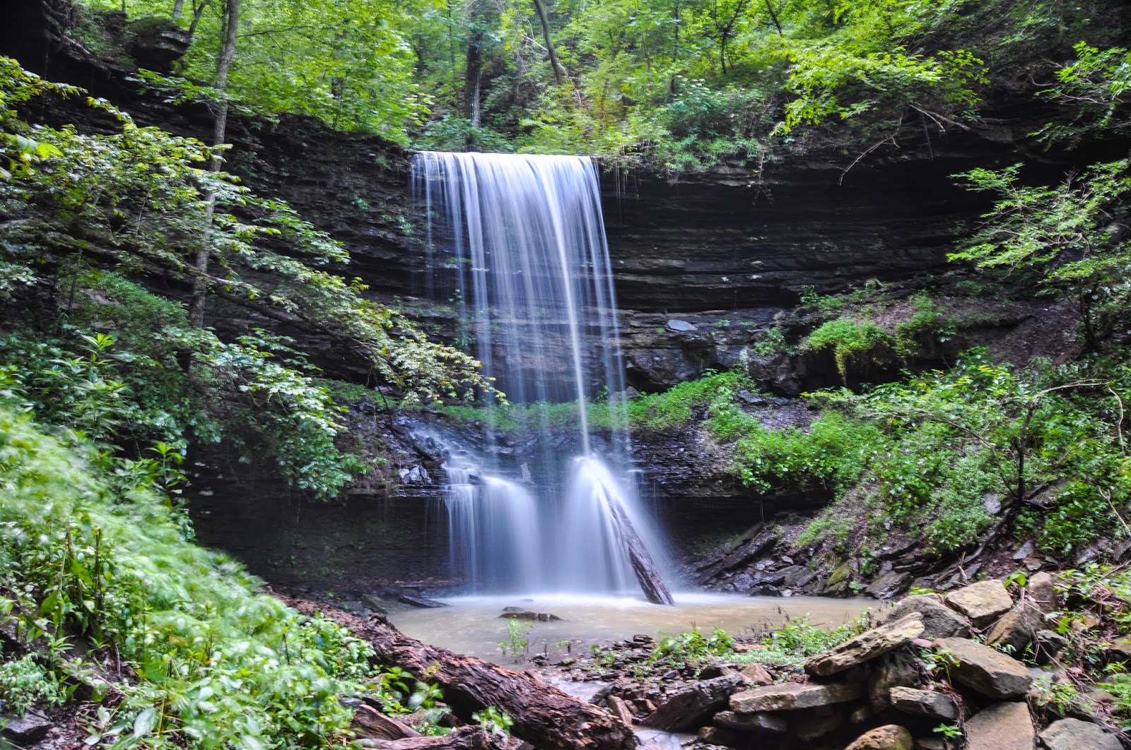
Accord Hollow Falls
To get to the base of Accord Hollow Falls, stick to the base of the rock cliff part of the bluffline until a second bench (more of a ledge) starts to form.  Then drop below that ledge and stick to the base of that rock face until you come around to the base of Accord Hollow Falls.  This waterfall is beautiful in photos, but is awesome in person.  It is about 66 feet tall, with two distinct tiers. The power and majesty of this waterfall is fantastic, especially when it is flowing very well as it was today.

We hung around Accord Hollow Falls for quite a while; it is definitely that type of waterfall.  There is another waterfall pouring off the northwest bluffline, but today it was all but obscured by the spring vegetation.  We eventually made our way back.  By the time we were all back, it was going on 6:00 pm.  We were starving, and even Boomer was worn out.  So we decided to forego the trip to Estep Creek Falls this time, as well as Cove Creek.  But I made a mental note to set an alarm and join Dan, Jim, and David on the Cove Creek hike in the morning.

I would highly recommend this hike, but this is one I would not do without a GPS.  You could find your way without one, but it would be real easy to get lost here as well.  
GPS Track - Accord Hollow