6/20/2015 - Cove Creek Waterfalls
GPS Coordinates: (Latitude, Longitude, Elevation)
Parking location: 35.60064 -93.58337, 1015 ft.
Access thru upper bluffline: 35.61371 -93.58133, 1672 ft.
Access above Never Again Falls: 35.61316 -93.58107, 1553 ft.
Never Again Falls: 35.61351 -93.58037, 1589 ft.
Access above Never Ever Again Falls: 35.61253, -93.58171, 1488 ft.
Never EVER Again Falls: 35.61289 -93.58117, 1517 ft.
Access above Cove Creek Cascade: 35.61200 -93.58200, 1437 ft.
Cove Creek Cascade: 35.61218 -93.58160, 1496 ft.
Access above Log In The Way Falls: 35.61087 -93.58268, 1324 ft.
Log-In-The-Way Falls: 35.61095 -93.58222, 1354 ft.
Unnamed Falls #1: 35.61107 -93.58418, 1372 ft.
Unnamed Falls #2: 35.61039 -93.58350, 1285 ft.
Curve Ball Falls: 35.60987 -93.58317, 1245 ft.
Unnamed Falls #3: 35.60941 -93.58361, 1228 ft.
Pet Friendly: Not very dog friendly due to the steep, rugged, and slippery terrain in some places. I left Boomer at home this trip. I think he could have handled it okay, but some of the terrain would have been challenging.
Motorcycle Friendly: Yes! You park right next to Highway 103 at the Cove Creek bridge. This section of Highway 103 to Oark is actually a very popular riding destination for Arkansas bikers. If you want to combine a great ride with a great hike, and polish it off with burgers at the Oark General Store, this is perfect.
GPS files (.gpx format): Maps of GPS tracks are at the bottom of this post
GPS waypoints for Cove Creek Polyfoss
GPS track for Cove Creek - part 1
GPS track for Cove Creek - part 2
GPS track for Cove Creek - part 3
GPS track for Cove Creek - part 4
 |
Curve Ball Falls - with (L-R) David, Rick, Dan, and Jim
Photo by David Dedman |
Cove Creek is the creek everyone knows and no one notices. The bridge across it on Highway 103 is at the first hairpin turn as the highway winds its way up the mountain through switchback after switchback. My friend, Dan Frew, had told me about one of his excursions going down a tributary creek high on the mountain, looking for waterfalls. He found himself down on Cove Creek itself, but never expected to find any waterfalls there. He did find three significant waterfalls right on the main creek. The photos were beautiful. A couple of weeks later, Jim Fitsimones, another friend and hiking partner, made a trip up Cove Creek to photograph the same waterfalls. So when I ran into Jim while waterfall chasing yesterday and he mentioned going back to Cove Creek again early this morning, I was certainly interested.
 |
| Never Again Falls |
So I got up early this morning, ate a huge breakfast, and took the FJ up to the Cove Creek bridge. Dan, Jim, and David Dedman, another friend and hiking partner, and I met at 6:00 am to get a big hike in before the heat of the day set in. We had received a good deal of rain the previous couple of days, and this seemed like the perfect time to thoroughly explore this area. That did turn out to be the case. We visited five major waterfalls on Cove Creek itself, and a number of smaller waterfalls and cascades on the main creek and tributaries.
 |
| Never EVER Again Falls |
Driving directions for this one are very simple. From the juncture of Highways 64 and 103 in Clarksville (Main Street and College Street), go north on Highway 103 for 12.3 miles and park at the bridge over Cove Creek. Couldn't be simpler. If you want to visit the waterfalls in this drainage, I would highly recommend you don't go the route we went today. Instead, simply park at the bridge, hike up Cove Creek on the left (west) side, then hike back the way you came. We wanted to start at the top of the entire system, so we left the rest of the vehicles at the parking location and Dan's wife, Shelly, was kind enough to drive us up to Dogwood Lane at the top of the Cove Creek drainage.
 |
| Cove Creek Cascade |
We started our hike heading down the bluff toward Cove Creek and immediately ran into our first problem; there seemed to be no way down below the upper bluffline. There is always a way, though, and eventually we found a break downstream we could climb down. This was a very steep descent, and was the first of many today that involved some sliding on the seat of my pants. While scouting for a way down, we could see the first of the waterfalls we would find on the main creek itself. I should note that none of the waterfalls on this creek had been documented. Brian Emfinger had posted a Panoramio photo of a waterfall on a tributary east of Cove Creek, but as far as I know, no one in modern times had seen these spectacular waterfalls until Dan happened upon them.
 |
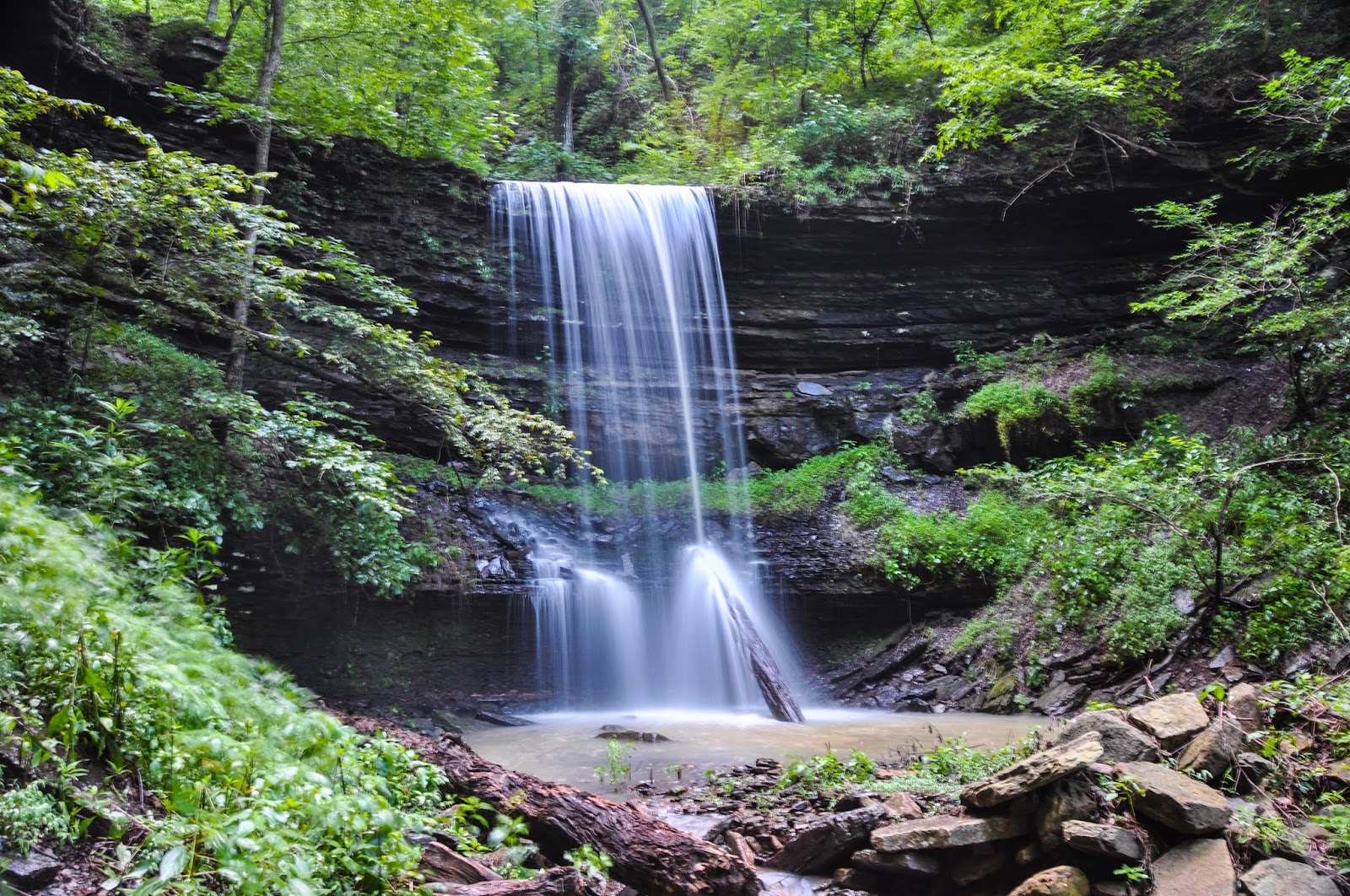
| Log-In-The-Way Falls |
Making our way back up to it was almost as difficult as getting through the upper bluffline. By the time I finally got to the base of the waterfall, I had an appropriate name. This was a beautiful two tiered waterfall, and it is always a little thrill to find something like this in the wilderness. That being said, at the time I was pretty sure I would not want to so through that much effort to see it again. Never Again Falls seemed completely appropriate for this one.
 |
| Never Again Falls |
Leaving Never Again Falls, we headed downstream, still on the right (west) side of Cove Creek. One important thing to note about this area is that the west side of the creek had all the access points. I scouted the east side as we hiked today, but that side is considerably steeper and less accessible than the west side. The west side was certainly bad enough itself. We had actually passed the top of the next major waterfall on our way to Never Again Falls, and soon got back to it. We had to go far downstream to get to an access point through the bluffline above this one as well, then make our way back upstream (again) to this waterfall.
 |
| Never EVER Again Falls |
We bushwhacked through some very rugged terrain to get back up to the base of this second waterfall, and found what we should have known to start with - stick to the base of the bluffline as well as you can. Water dripping off the bluff made conditions there fairly wet, but it was much easier and safer hiking. By the time we arrived at the base of the second waterfall, David mentioned never, EVER coming back to this waterfall. So Never EVER Again Falls it is. I don't look for names for every little waterfall, but major waterfalls on a large creek should have a handle for reference.
 |
| Cove Creek Cascade |
Leaving Never EVER Again Falls, we made our way downstream, still on the right (west) side. We soon came to the next waterfall, Cove Creek Cascade. The break to get below the bluffline to the base of this one was about 50 yards downstream, so not quite as extreme as the two waterfalls above it. The slope of this access point was still very steep, but also not as extreme as the first two waterfalls we visited. We made our way back upstream to the base of Cove Creek Cascade, a tall, steep, waterfall in the 25 to 30 foot range that cascades all the way down.
 |
| Log-In-The-Way Falls |
Cove Creek Cascade was the highest waterfall in the drainage that Dan had seen on his previous expedition, so at least now we were on somewhat charted territory. Heading downstream again, we found a break to get below the next bluffline, about 50 yards downstream from Log-In-The-Way Falls. This was the only one of the five major waterfalls on Cove Creek itself that looked like the classic Ozark waterfall. Cove Creek spills directly off a flat sandstone ledge and falls unimpeded to a pool below.
 |
| Unnamed Falls #1 |
Downstream from Log-In-The-Way Falls, we crossed a tributary that seemed to have a good deal of water flow itself. Jim and I hiked upstream along this creek, passing Unnamed Falls #2 along the way. Approximately 150 yards upstream we found Unnamed Falls #1, a classic "spill over the ledge" Ozark waterfall in the 12 foot range. The hike up to this one is a little steep, but it is nice enough that it is worth the effort. I stopped at the smaller Unnamed Falls #2, which has a number of small cascades above it.
 |
Curve Ball Falls - with Rick on crag at top
Photo by Dan Frew |
Back on Cove Creek, Curve Ball Falls was a short distance downstream from the tributary creek containing Unnamed Falls #1. I marked the GPS coordinates for this waterfall standing on a rock jutting out from the top of the waterfall. Dan and David had already arrived at the base of the waterfall and snapped my favorite photo of the day. More often than not, I'm just hiking with Boomer so there isn't any way to get a shot like this. Out of all the beautiful waterfalls in this drainage system, I like Curve Ball Falls the best. Whatever kind of waterfall you like, this has a little bit of everything. It has spill offs, straight sections, and a curving cascade of falling water on one side. Spectacular.
 |
| Unnamed Falls #3 |
From Curve Ball Falls we headed downstream, stopping briefly at another tributary creek containing Unnamed Falls #3. There are other small cascades on Cove Creek, and some side drainages containing small cascades and waterfalls. But for the most part, it is a simple bushwhack in and out below Curve Ball Falls.
The terrain flattens out considerably in this lower part of Cove Creek, approximately 2/3 of the total one mile from the parking location to the uppermost waterfall, Never Again Falls. So all five of the significant waterfalls are bunched in the upper 1/3 of Cove Creek. Hiking below Curve Ball Falls is what I would call a hike with medium difficulty. It is all bushwhack, but not too steep, not a lot of rock hopping, and with a manageable amount of undergrowth.
 |
| Unnamed Falls #2 |
Above Curve Ball Falls, however, is a totally different story. I would call this a very difficult bushwhack, getting more difficult the higher you go in the drainage. I know there was a reason we called the highest waterfall "Never Again Falls", but it appears I may need to pay the area a return visit.
After getting home and entering all the trip data from my GPS, and looking at the high resolution imagery of the area, I believe another large waterfall is hiding up above Never Again Falls. Only about 70 yards to the northeast of that waterfall is where the main creek flows over the upper bluffline. You never know until you get into the area and lay eyes on it, but I would expect that to be a large layer of hard sandstone bluffline, creating just the right geology for a good sized waterfall. Now that thought will be a little bug in my head until I break down some day and make a return visit to the area.
All in all, another great hike in the Arkansas wilderness. We met at the bridge at 6:00 am and were through the hollow and back at the parking location by mid-morning, before it got too warm. I was still dripping with sweat by the time we finished. From Never Again Falls to the parking location is right at one mile as the crow flies. But as the hiker hikes, my GPS recorded 2.81 miles of actual hiking. Some of that was exploring side drainages, but mostly it was having to come downstream quite a way to a break in the bluffline, then doubling back up the creek to the base of a waterfall.
If you are up for a great hike to visit waterfalls that have rarely ever been seen, I would highly recommend this one. My recommendation would be to park at the bridge, then go upstream to Curve Ball Falls. From there, you can continue upstream to visit the other waterfalls in the area, knowing that it will get increasingly difficult as you go higher. That way, you can set your own pace, and hopefully know your own limits, and stop when you have had enough.
 |
| GPS Track - Upper Portion of Cove Creek |
 |
| GPS Track - Cove Creek |


Wow. Arkansas has some really nice waterfalls!
ReplyDeleteThis one is going on the must hike list!
ReplyDelete