Tuesday, December 13, 2016

Arkansas Sphinx, between Hagerville and Sand Gap, Arkansas Ozarks

12/13/2016 - Arkansas Sphinx

GPS Coordinates: (Latitude, Longitude, Elevation)  
  Parking Location #1:  35.63916   -93.29101
  Parking Location #2:  35.65107   -93.29597
  Small bluffline break:  35.64045   -93.29036
  Arkansas Sphinx:  35.64059   -93.28896,  1715 ft.

Pet Friendly: Dogs on or off leash should be OK. 

Motorcycle Friendly:  Yes. Parking location #2 is right on Highway 123, and there is a nice flat parking space at the junction of CR-5741 to park at, across the highway from the trail you will be taking.  Parking location #1 is a little over a half mile down a not-so-good dirt road, but easily doable on your big bike for the short distance.

Hiking Statistics: There are three segments of today's hike, and most folks will only need one of them so I will detail each separately:
 - Route #1 to the Arkansas Sphinx is only 0.17 miles (945 feet) long, with an elevation gain of 350 feet.
 - Route #2 to the Arkansas Spinx is 1.27 miles, with an elevation gain of 638 feet.  There is one section of trail near the base of the knob that goes downhill slightly, then back uphill.
 - If you take one route in and the other out, as I did today, the road distance between the two parking locations is 1.15 miles, with a highest-to-lowest distance of 191 feet.  It does go downhill from parking location #1 to Highway 123, and slightly uphill on Highway 123 to parking location #2.

GPS files (.gpx format) - maps with GPS tracks are at the bottom of this post
  GPS track for route #1 to Arkansas Sphinx
  GPS track for route #2 to Arkansas Sphinx

The Arkansas Sphinx
Since there is no water in the creeks for the waterfalls, I went another direction today.  There are many nice hikes in the Ozarks to places that don't need water to be an attraction, and today I just wanted to get out in the woods.  I had recently seen a rerun episode of Exploring Arkansas that featured the rock formation known as the Arkansas Sphinx.  Then, last week, I went to a slide show presented by Tim Ernst and noticed that one of his new photo books had the Arkansas Sphinx on the cover.  To top it off, I got a copy of Danny Hale's new hiking guidebook in the mail a couple of days ago, and when I cracked it open it was on the page for the Arkansas Sphinx.  I can take a hint.  Clearly, the Cosmos wanted me to go to the Sphinx, and who am I to argue with fate?  To top it off, my friend and frequent hiking partner, Dan Frew, was the guy that found this hunk of rock many years ago and dubbed it the Arkansas Sphinx.  Not wanting to tempt the wrath of The Cosmos, I packed up and headed out.  Bethany was taking Boomer to the vet to look at an injured leg, so I was on my own today.

Parking Location #2
To get to the parking location, the driving directions are pretty simple.   
  - For Parking Location #2, from the community of Pelsor (Sand Gap), go 16.2 miles south on Highway 123, then turn left onto an old road with a gate opposite the junction with Johnson County CR-5741.  This is 3.3 miles past the Haw Creek Campground.  If you are coming from the other direction on Highway 123, this junction is 10.5 miles north of Hagerville.
  - For Parking Location #1, go 0.6 miles south on Highway 123 from Parking Location #2, and turn onto CR-4840.  Go another 0.6 miles on CR-4840, and you are at Parking Location #1.


The Arkansas Sphinx
There are a couple of routes to the Arkansas Sphinx.  If you just want to go see it and cross it off your bucket list, I would recommend what I call route #1.  It is the most direct, and definitely the shortest.  Route #2 is not long, 1.3 miles, but route #1 is much shorter at only 0.17 miles.  Both routes are very steep as you go up near the top of Hess Knob that the Arkansas Sphinx sits on.  Route #2 also climbs almost twice as much, altitude-wise, as route #1, but the first part is spread out over almost a mile of trail.  Today, I wanted to get at least a moderate hike, so I went on route #2 for the hike in.  Because I prefer to see as much different scenery as possible, I hiked back out on route #1, then hiked along the road from parking location #1 to parking location #2.


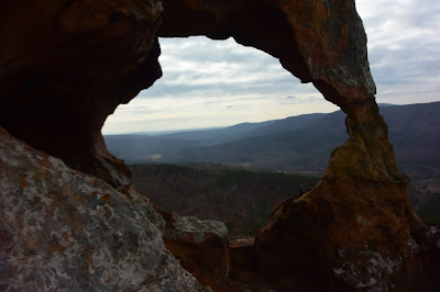
Spectacular views - through the eye of the Sphinx
From parking location #2, you hike along an old logging road up to a food plot at about 0.7 miles in.  This old road is in decent shape and would be easily drivable with a good 4WD vehicle, but is always blocked off by the forest service.  They go in occasionally and bush-hog the food plot and road, but that's about all the maintenance it gets.  In any case, I have never seen the gate open on it, but it does make for an easy hiking trail.  Going out the other end of the food plot, the old road is more of an ATV trail but still makes for easy hiking.  You can take this ATV trail up all the way to the top of the knob.  When you get toward the base of the top part of the knob, there is a dense thicket growth in front of you, and the ATV trail makes a hard left turn.  Stay on the ATV trail, and it winds around the base a short distance, dipping down and then turning up the mountain, taking you all the way to the top.  I saw no recent signs of ATV traffic, but it was in fairly good shape for hiking.  


Arkansas Sphinx
Just stay on this ATV trail and you will be okay.  The trail takes you to the top of the knob, and from there you can see the Arkansas Sphinx on the slope on the other side of the mountain.  This route takes you higher up on the mountain, called Hess Knob, and from here you can see forever.   Hess Knob juts up to an elevation of almost 2000 feet, and you can see quite a distance in all directions.  The views are quite spectacular, and if you climb up to the Sphinx by route #1, you should climb the additional 200 feet or so to check out the scenery.  The Arkansas Sphinx itself is just a big chunk of sandstone, but it's a pretty awesome looking rock.  I'm no geologist, but I assume this is all that remains of a large sandstone layer, everything else having eroded away over time.  There are a couple of holes through it, one in the "tail", and one running through the north-south mid-section.  To be honest, I think it looks as much like a duck as it does The Sphinx, but "Arkansas Sphinx" has a much more impressive ring than "Arkansas Duck Rock".  So, good choice of names all those years ago, Dan.


Parking Location #1
Note the two trees with an "S" marking the trail.
After spending a good deal of time taking in the views and climbing on the Arkansas Sphinx, I headed back.  This time, I took route #1.  There is a pretty good volunteer trail going straight downhill from the Sphinx, and it is visible enough this time of year to easily follow it.  When the trail goes over a small bluffline below the Arkansas Sphinx, it zigzags down a small break along the bluff.  I think this route is somewhat steeper, but it's also for a much shorter distance.  When the trail starts off from the road, it is not quite as visible as it is higher up, but someone has helped you out by marking some trees.  At parking location #1, there is a big white "S" spray painted on a tree.  The trail goes around this tree on the left, then breaks right and goes to another big tree with an "S", and swings left around this second tree.  After that, it is very visible and easy to follow.  One word of caution; on the lower part of this route, it is thick with 'Devil's Walking Sticks' on both sides of the trail.  If you are not familiar with these small trees/bushes, they are indeed the work of the devil.  They have very sharp thorns on the trunks and branches and will poke right through heavy gloves.  Just be aware they are there and don't grab any small trees for support.

After coming down the trail to parking location #1, I hiked along CR-4840 and then back up Highway 123 to where I had parked the FJ Cruiser at parking location #2.  Even with this additional distance, I only hiked a total of 2.7 miles.  I would rate this as a moderate hike only due to the steepness of the trail, no matter which route you take to get there.  The trails in both routes are in fairly good condition, so hikers of all ages should be able to do this hike if they can make the climb.  
Blue - Route #1 to Arkansas Sphinx
Red - Route #2 to Arkansas Sphinx


3 comments:

  1. I also suggest you reed this guide Rick: http://www.travelindependent.info/what-to-pack-travel.htm
    You really need the help.

    ReplyDelete
    Replies
    1. Thanks, man. I clearly need all the help I can get.

      Delete