GPS Coordinates: (Latitude, Longitude, Elevation)
Parking Location: 35.72578 -93.28148, 1318 ft.
Bluffline break (east): 35.73007 -93.28952, 951 ft.
Little Cow Falls (5 Waterfalls): 35.72959 -93.28977, 961 ft.
Elsie Falls: 35.72975 -93.29030, 1016 ft.
Norman Falls: 35.72983 -93.29095, 1053 ft.
Cincinnati Freedom Falls: 35.72676 -93.28989, 995 ft.
Little Cow Creek Cascade: 35.72624 -93.29025, 1006 ft.
Falls #5: 35.72219 -93.29110 1118 ft.
Falls #6: 35.72606 -93.29034, 1009 ft.
Bluffline Break (west): 35.72847 -93.28967, 968 ft.
Queenie Falls: 35.72816 -93.28943, 968 ft.
Falls #8: 35.72797 -93.28817, 1076 ft.
Ormsby Cascades: 35.72986 -93.29051, 1029 ft.
Pet Friendly: Dogs off leash should be OK. If your dog needs to be on a leash, it is doable but difficult because this is all bushwhack hiking. There are some steep bluffline breaks. Boomer has been here several times without problems.
Motorcycle Friendly: No, not at all friendly to your big bike. The parking
location is several miles down dirt roads.
Hiking Statistics: The Little Cow Creek watershed is just over 1100 feet elevation change from top to bottom. Today I hiked 3.05 miles with a highest-to-lowest difference of only 481 feet. Due to the ruggedness of the terrain and the box canyon between Little Cow Falls and Cincinnati Freedom Falls, there are a couple of climbs down below blufflines and back up. This is a rugged area, and the bluffline breaks you need are somewhat steep but manageable if you are careful. There are no trails, but it is relatively easy bushwhacking in most areas. Overall, I would rate this a moderate bushwhack.
GPS files (.gpx format) - maps with GPS tracks are at the bottom of this post
Cow Creek area waypoints
Little Cow Creek track
Update 11/15/2019 - Last winter, there was tornado damage in the woods along Pine Ridge Road where the parking location is. They have logged the downed trees around the parking spot, and it is actually easier to park there now. The very top of the hike-down drainage has a few downed trees still, but it is not difficult to get past them. Below the top of the hike-down drainage, nothing was damaged.
 |
| Cincinnati Freedom Falls |
 |
| Little Cow Falls Grotto |
 |
| Little Cow East Falls |
 |
| Norman Falls |
- Go north on CR-5741 for 5.7 miles, then
- Turn right on CR-5680, also known as Pine Ridge Road.
- Go 3.5 miles on Pine Ridge Road, and turn left (west) onto a Jeep road. This area immediately off Pine Ridge Road has been used as a campsite at some point in the past. The area is lousy with deer and turkey, but I have never seen anyone else in this valley, nor any signs of hunters. Instead of following the Jeep road around to the left, bear to the right along an old trace road and park. This was a logging road many years ago and has a berm across it now. I park right at the berm.
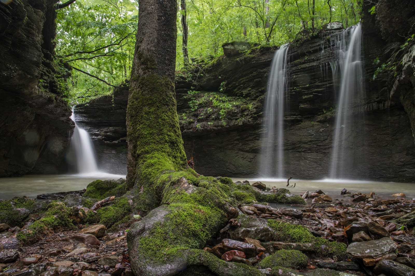
From this parking location, head down into the drainage directly below you (west), away from Pine Ridge Road. This is the large side drainage that flows over the bluffline at Queenie Falls, right between Cincinnati Freedom Falls and Little Cow Falls. The top of the drainage is literally just a few yards from the parking location. Unlike most small creeks, bushwhacking along this one is fairly easy. If you have an aversion to walking along the creek, you can follow it higher along the bluff on the right (north) side. There is less undergrowth down along the creek. On the ridge above this side drainage, the saplings and other growth get fairly thick, and if you hike down to Little Cow Creek up on the bluff, you will also miss the smaller waterfalls along the way. Follow this side drainage all the way down to the large bluffline towering over Little Cow Creek. Along the way, there are numerous smaller waterfalls, and one, Unnamed Falls #8, that is about 10 feet tall.
There are large bluffs on both sides of the creek for the entire quarter mile between Little Cow Falls and Cincinnati Freedom Falls, and bluffline breaks are few and far between. I have included GPS coordinates above for a bluffline break on each side of the creek, but be aware that these are doable but certainly not what you would call good bluffline breaks. To get below the blufflines, look to the right (downstream) of the top of Queenie Falls. There is a break there you can climb down, then make your way along the base of the bluff toward Queenie Falls. On all my previous visits, Queenie Falls did not have enough flow to look very good. Today, it was certainly photo-worthy.
You'll notice that many of the new waterfall finds here already have names, which is something highly unusual for me. The "namer of waterfalls", my wife Bethany, thought I should keep with tradition in the Cow Creek basin and name all of the waterfall finds for famous cows. I don't know a lot of famous cows, but one I remember is the story of Cincinnati Freedom. I'm a big freedom lover, so I gave that name to the waterfall I thought was the biggest and most impressive in this area. I won't bore you with a lot of detail on these names, but you can follow the links on each to see where the names come from. Queenie the cow was Cincinnati Freedom's BFF at the famous cow refuge in New York where she lived out her life after becoming a celebrity, so I gave that name to this waterfall nearby.
Once you make your way below the bluffline, head upstream and you will be able to see Cincinnati Freedom Falls at the head of the canyon almost immediately. The canyon has huge overhangs on each side that seem to amplify the sound from the waterfall. This is a beautiful waterfall with a large pool and a couple of smaller streams spilling over the west rim of the bluff into the pool as well. Being on the main creek, Cincinnati Freedom Falls gets all of the water in the entire drainage above it funneled over the waterfall so it will maintain a nice flow even in dry times like this. On my first visit, there was much less flow, but the water was crystal clear. From the top of the waterfall, the pool looked like it was 8-10 feet deep. It's difficult for me to size the height of the waterfall without something next to it to scale it to, but I would estimate it to be in the 30-foot range.
Today was looking like a great day to visit this little polyfoss area. I could have lived without the rain, but I did appreciate the cloud cover. I ended up having to wade through the creeks a few times anyway, so I ended up pretty much soaked despite having had the foresight to take a heavy raincoat along. Unfortunately, as I was taking some photos of Cincinnati Freedom Falls, that "perfect day" scenario started to unravel. I noticed the battery indicator on my camera had turned red, meaning I had a critically low battery level. I had forgotten to fully charge the battery in the camera before leaving, but no worries; after all, that's why I keep a spare battery in the pack, right? Unfortunately (there's that bad word again), I had just returned from a long trip to the Texas Hill Country and the spare battery was in a different camera bag, not my sling pack. Aaarrrgh! What a rookie mistake! I enabled 'Airplane mode' on the camera to save some battery, and started just turning the camera on long enough to get a shot or two of each waterfall. Unfortunately (again!) there are a lot of waterfalls here, and I still ran out of battery before we were done, but I got a shot of almost all of them. The photos you see here are the first or second take on each one because that's all I ended up with.
From my previous exploration, I knew there were only a few smaller waterfalls upstream, so from Cincinnati Freedom Falls I headed downstream to Little Cow Falls. The top of Little Cow Falls is only a quarter of a mile downstream from Cincinnati Freedom Falls. There are actually five waterfalls here, but the two on the west side are fed from the same side drainage, and one of the two on the east side is seepage from the same side drainage that feeds the waterfall outside of the grotto containing the other waterfalls. So, depending on how you look at it, I guess you could say there are three to five waterfalls here. I simply refer to the one actually on Little Cow Creek as Little Cow Falls, and the others as Little Cow West Falls or Little Cow East Falls. I'm a simple man, and there just aren't enough famous cows to name waterfalls after.
You can hike down the right (east) side of the grotto, cross the side drainage that feeds Little Cow East Falls, and look for the bluffline break just downstream. Like the bluffline break at Queenie Falls, it is steep and slippery, but it is usable. I have now slipped and fallen on my butt at each of these so I can vouch for the steepness and slipperiness. Oddly enough, it was wetter and slippery today than any of my other visits, and I didn't fall on my butt once today. Maybe I'm learning. While not nearly as tall as the grotto at Cincinnati Freedom Falls, the one at Little Cow Falls is more enclosed. You have to pass behind the other waterfall from the east drainage to get into and through the entryway into this circular grotto. Even with the higher flow rates today, the mouth of the grotto is wide enough to drain adequately, and Boomer and I were able to get into the grotto to the small island just inside. I had to stand in shin-deep or knee-deep water to get some shots, but I was already soaked from my toes to my waist.
After climbing the bluff on each side to get back to the top of Little Cow Falls, I found that what works best for me is going back up the way I came down, next to Little Cow East Falls. Circling back around, when you are opposite from Little Cow West Falls, look up and you will see Elsie Falls pouring over the next bluffline, much taller than the waterfalls below it. This time of year, it may be somewhat obscured with greenery. Boomer and I crossed Little Cow Creek at the top of Little Cow Falls and headed up this tributary to the west. Check out Little Cow Falls from the top before heading up the side drainage toward Elsie Falls. It has a slot at the top, causing it to jet out into the grotto. I think this one looks as good or better from the top as it does from the base. Little Cow Creek funnels into a slot just before entering the grotto, then cascades down a steep slot before spilling out over Little Cow Falls into the grotto.
Elsie Falls, named for Elsie the Cow, is fairly tall, about 24 feet tall, and had decent flow today. On my first hike, I was surprised to find any flow at all here in a side drainage, so I followed this drainage for a good distance upstream. It is fairly wide and goes a half mile back toward Jim's Ridge to the west, so it has a lot of area to collect water from. From Elsie Falls, You can go above the bluff on the left and headed toward Norman Falls, another find from my initial trip here. Norman Falls is only about a hundred yards upstream, and along the way, there is yet another string of small waterfalls that I didn't even notice on my
initial exploration because the creek was dry at this point. It is small but very pretty, and definitely "photo worthy", so I decided to name it Ormsby Cascades, in honor of Maudine Ormsby, the prettiest little heifer to be made homecoming queen at Ohio State University. I'm a big OU Sooner fan myself, but many of our relatives are from Ohio and are rabid Buckeye fans so they will get a kick out of this. Please, before any of you slam me in the comments for being politically incorrect or disrespectful for calling Maudine a "heifer", please follow the link and read her story. I am not, in fact, politically correct. But this isn't one of the times I'm practicing my incorrectness.
Norman Falls is named for Norman the cow, of course, and is only coincidentally the hometown of my OU Sooners. Yes, I know Norman is a boys name. But in the sequel movie, it is quite obvious that Norman is a cow. Last fall, it barely had a trickle of flow, and today it looked much better. It is still, however, somewhat subpar and you can tell what a more normal flow rate for this drainage would be. Look at the photo from last fall and you can see where it has carved out the rock in the bottom of the pool below. That is where the flow coming over Norman Falls normally falls, jetting out a few feet more from the current base. It has carved a good sized bathtub in the pool, right out of solid sandstone. This, at least, gives me an idea of just how great this area might be when we get back to normal spring wetness. We get the occasional rains to keep the Ozarks green, but overall we have been in an extended drought for about five years.
 |
| Little Cow Falls |
 |
| Queenie Falls |
 |
| Little Cow Falls Grotto |
 |
| Cincinnati Freedom Falls |
 |
| Elsie Falls |
 |
| Little Cow West Falls |
 |
| Little Cow East Falls |
 |
| Maudine Ormsby Cascades (Middle Drop) |
 |
| Elsie Falls |
 |
| Ormsby Cascades (lower drop) |
 |
| Norman Falls on 10/29/2016 Notice the trough eroded into the rock from the normal jet of water over this waterfall. |
 |
| Norman Falls today The flow is much better with the recent rain, but clearly not as much as the "normal" spring water flow that carved out the trough in the bottom of the pool |
|
| Little Cow Falls Grotto |
 |
| Queenie Falls |
 |
| GPS track for Little Cow Creek |
 |
| Blue - GPS track for initial exploration Red - GPS track major water features in Little Cow Creek Green - Jeep/ATV trail to upper prongs |
You've got a terrific hiking blog, Rick. This looks like a great overnight camping trip for me (3 hours drive). I love all the data you provide and the great photos.
ReplyDeleteThanks! Glad you like the blog. Definitely a nice camping spot, but really doesn't take that long to hike. Easy day hike, even with 6 hours of driving.
ReplyDeleteUsing information from your blog I scouted this area back in February and yesterday (4/14) lead an Ozark Society hike into Little Cow. The falls were cranking after the big rain and everyone loved it. Thanks for sharing your finds.
ReplyDeleteYou are welcome! I'll bet it was spectacular after the rain the night before. Glad everyone enjoyed it.
ReplyDeleteRick, what are the dirt road conditions like getting to this hike? Are they passable in a regular passenger car, or would you recommend 4WD?
ReplyDeleteBeth, the road to this one is actually pretty good. It is several miles down a gravel road, but this is the road that goes to a low water bridge over Big Piney Creek and the road is maintained by Johnson county. You should have no trouble in a regular passenger car. Where I normally park is very close to the road, on an old logging road. You may want to park right along Pine Ridge Road, but it is only 20 yards or so off the road to where I normally park anyway. If you can enter coordinates in your GPS navigation unit (or Google maps on your phone), it should know Pine Ridge Road and take you right to it.
Delete