4/6/2016 - Hurricane Falls and 17 other waterfalls along Hurricane Creek
GPS Coordinates: (Latitude, Longitude, Elevation)
Parking Location: 35.49502 -92.87347, 1892 ft.
Falls #1: 35.49272 -92.88169, 1508 ft.
Tropical Storm Falls: 35.49056 -92.88244, 1523 ft.
Falls #3: 35.49076 -92.88278, 1504 ft.
Hurricane Falls: 35.49468 -92.88370, 1267 ft.
Typhoon Falls: 35.49558 -92.88415, 1243 ft.
Falls #6: 35.50171 -92.88265, 1129 ft.
Three Falls Canyon: 35.50353 -92.87870, 1072 ft.
Falls #8: 35.50539 -92.88176, 1065 ft.
Falls #9: 35.50574 -92.88151, 1066 ft.
Falls #10: 35.50949 -92.88305, 1110 ft.
Tempest Falls: 35.50955 -92.88266, 1075 ft.
Falls #12: 35.51364 -92.88110, 980 ft.
Bonus Falls: 35.51463 -92.87659, 1001 ft.
Wolf Den Grotto Falls: 35.51240 -92.87313, 1071 ft.
Howling Grotto Falls: 35.51213 -92.87307, 1097 ft.
Double Grotto Falls: 35.50925 -92.87313, 1140 ft
Falls #17: 35.50855 -92.87401, 1122 ft.
Falls #18: 35.50493 -92.87347, 1210 ft.
Pet-Friendly: Dogs off leash should be okay. If your dog needs to be on a leash, a bushwhack like this one is not advisable.
Motorcycle Friendly: Maybe. Parking is just off White Oak Mountain Road. It is over seven miles on a gravel road, but it is a well-maintained road and could be okay for heavier bikes.
Hiking Statistics: From top to bottom, the Blue Hole SIA is over 1000 feet of elevation change. Today's hike in the upper Hurricane Creek portion was 9.52 miles with a "highest to lowest" elevation change of 950 feet. This was almost all bushwhacking, although the very beginning and end of the hike were along an ATV trail. Hiking conditions were about average for bushwhacks in the Ozarks. In some areas, there was virtually no undergrowth, in others it was thick. There was a good deal of rough terrain and lots of rock-hopping on this hike. I would rate this a difficult bushwhack due to the length of the bushwhacking and the rough terrain. We were hiking for 6 hours and 46 minutes on the track at the bottom of this post.
GPS files (.gpx format) - Maps of the GPS track are at the bottom of this post.
Hurricane Creek and Blue Hole SIA waypoints
Hurricane Creek south prongs track
 |
Hurricane Falls (29 ft) - with Rick
Photo by Dan Frew |
I had made three extensive bushwhacks in the Blue Hole SIA (Special Interest Area) within the last week, and thoroughly enjoyed all of it. My friend and frequent hiking companion, Dan Frew, wanted to hike even more of it along Hurricane Creek, and I was happy to tag along. Note that there is more than one "Hurricane Creek" in this same part of Arkansas. This Hurricane Creek is NOT the Hurricane Creek with the wilderness area that drains into Big Piney Creek north of Fort Douglas. THIS Hurricane Creek is the one on White Oak Mountain, north of Hector. It flows through the Blue Hole area and drains into the East Fork of the Illinois Bayou. Today, we were going to hike the big prongs on the south end of Hurricane Creek, where its headwaters are. I met Dan in Dover, and we headed over to White Oak Mountain.
 |
| Tropical Storm Falls (22 ft) - with Dan |
To get to the parking location, drive north from Hector on Highway 27. Less than a mile from the Big Piney Ranger station in Hector, you cross over Dare Creek. Immediately after crossing Dare Creek, turn right onto White Oak Mountain Road (aka FR-1301, or Grapevine Mountain Road on some maps). Go 7.7 miles on White Oak Mountain Road, and park at the ATV trail on the left. At 7.2 miles from Highway 27, be careful to bear left where the road branches at the 'Y' in the road. If you have a good (and narrow) high clearance 4WD vehicle, you may be able to go further down this ATV trail to park. Not knowing the trail, we parked just off White Oak Mountain Road. We took Dan's Jeep today, but any vehicle should be able to get to where we parked today.
 |
| Howling Grotto Falls |
We started our hike going down the ATV trail, which runs right along the spur between the two large southern prongs of Hurricane Creek. When we came to the top of the first major bluffline (at 35.50031, -92.87718), we turned left (west) and followed the bench at the top of the bluff. This was high enough above the creek that in all likelihood, any waterfalls would be spilling over this bluffline or would be a short distance above it. For exploring a vast drainage system, this is a good "divide and conquer" method to try to be as thorough as possible. If we find a good creek above the bluffline, we can drop below the bluffline and explore it to the main creek running through that prong or hollow.
 |
| Double Grotto Falls |
Our plan today was to explore the hollow in this big southwest prong first, then go over into the much smaller and shallower southeast prong, and finally hike up the big southern middle prong back to the Jeep. We hiked along the bench above this southwest bluffline almost all the way around to the end of this prong before finding the first waterfall. I marked Falls #1, but it did not have enough flow today to bother with further exploration in the area, so we moved on. We found Tropical Storm Falls further along the bluffline where the headwaters of Hurricane Creek itself poured over the bluff. Upstream, there were quite a few smaller waterfalls in the 2-6 foot range, as the creek tumbled down the steep slope at the top of this hollow.
 |
| Large Shelter Cave |
We found a break further around the bluffline that we could descend through and check out Tropical Storm Falls. Using Dan's height to scale this, it is about 22 feet tall, spilling down several steps and spreading before falling in a broader veil of water. If you are a frequent reader of this blog, you know that I have been complaining about the lack of rainfall this spring. Well, I'm still complaining. We have had very little compared to a normal spring in Arkansas, and every day things dry up a little more. The conditions around Hurricane Creek were no different, with the ground generally dry and leaf cover on the forest floor dry and crunchy. Given that, I can only imagine how spectacular some of the waterfalls we found in the Blue Hole SIA will look in normal (wet) spring conditions. Tropical Storm Falls looked pretty good today, so it should look fantastic with a little rain.
 |
| Falls #3 |
There is a fairly large shelter cave along the base of the bluff near Tropical Storm Falls, high enough that we could walk through it on our way around the bluff. Falls #3 was not far downstream from Tropical Storm Falls, but required a little effort to get around it and down to the creek, then back upstream to the waterfall. This is a beautiful waterfall with some not-so-beautiful logs jammed over it, making a clear shot of the waterfall almost impossible. One of the things missing in my photography bag of tricks is a good wide-angle lens. That would have been very useful today. Leaving Falls #3, we headed downstream.
 |
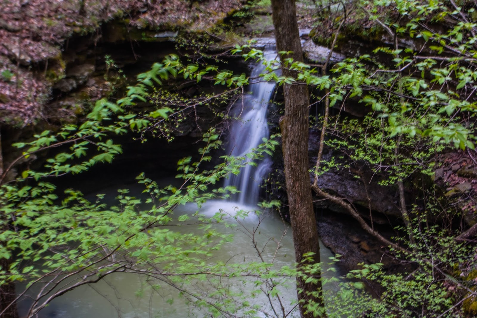
| Hurricane Falls (29 ft) |
We found the next waterfall over a quarter mile downstream. Approaching it from the upstream, we could tell looking over the top that it had a pretty good vertical drop. What we couldn't see until we hiked around and through a break to get to its base, was just how spectacular this waterfall looked. As soon as we saw this one, Dan and I knew this waterfall would be a standout among all the waterfalls in this drainage and would be deserving of the name Hurricane Falls. I really like the geometry of Hurricane Falls. The flow in Hurricane Creek may be well below normal, but because of the way the water hits several shelves on the way down, it looked great. It will be interesting to see if this one actually looks better this way. More flow in Hurricane Creek may push the water out and away from the wall, giving it more of a classic look. I intend to find out, but I suspect enough water will still hit those ledges to give it a unique look.
 |
| Typhoon Falls (30 ft) - with Dan |
Only a hundred yards downstream from Hurricane Falls, a major tributary creek flowed into Hurricane Creek from the right (west). Just upstream on it was Typhoon Falls. This is a tall waterfall, 30 feet from the top to where it falls into a small pool below. As I said, this is a major tributary creek, with appreciable flow even today. We did not explore further upstream, but after putting all the trip data into the topo maps, it appears there probably are some more significant waterfalls higher in the hollow above it. This creek had almost as much flow as Hurricane Creek itself.
 |
| Falls #6 |
From Typhoon Falls, we went downstream about a half mile before the next waterfall. Falls #6 is small in stature but big in flow. It is formed where Hurricane Creek squeezes between some very large rocks, forcing the water up and over a very small channel, then hitting a large rock that makes the water bulge upwards. It is also very difficult to get to without wading through the creek below it. We did find a hole at the bottom of the rocks that we could crawl through to get to it, but this hole may well be underwater with a little more rain. Crawling and squeezing back through the hole, we continued downstream.
 |
| Three Falls Canyon - upper two waterfalls |
From Falls #6, we hiked downstream approximately a quarter mile to an area where the creek narrows and forms a short canyon it has cut out of the rock over the years. At the start of this canyon are three waterfalls; one on Hurricane Creek, another very long cascade flowing in from a feeder creek on the west side, and yet a third downstream on the main creek. Since these three waterfalls are all grouped together, I simply called this Three Falls Canyon. This is a cool little area, no doubt even better during wet weather. The way the water is flowing off edges of rocks now, it will be a "must see" when I come back after some rain.
 |
Three Waterfall Canyon - third waterfall
Waterfalls one and two are visible upstream |
Whether you call this section of Hurricane Creek a wide slot canyon or a short and narrow canyon, you will definitely call it a neat area. At the end of the canyon area is Falls #8, a short, sidewinding, waterfall on the main creek that has another waterfall running off a large rock from a tributary on the west side. Only fifty yards downstream on Hurricane Creek is Falls #9, a wide cascade flowing into a large blue-green pool. Downstream, another tributary comes in on the left (west) side. We followed this feeder creek about a hundred yards up to Falls #10, a beautiful double cascade, flowing directly into Tempest Falls. This tributary creek had fairly good flow considering our current dry conditions. We did not explore higher, but there may well be other waterfalls in this drainage.
 |
| Tempest Falls |
Another quarter mile downstream on Hurricane Creek, we came to yet another creek flowing into it on the left (west) side. Falls #12 was just above the confluence of the two creeks. Even though we got an early start today, our hike was already well into the day, so we did not explore further in this side drainage. Just downstream from Falls #12, we came to the juncture with the creek from the other main prong of Hurricane Creek. To this point, I have been calling the creek that we had been hiking along "Hurricane Creek" because that's how the topo maps I am using has it labeled. The combined flow from the other two prongs is just as much if not more.
 |
| Falls #9 |
A few days ago, Dan had taken an ATV down to a point adjacent to where he thought there might be waterfalls in these two prongs. From the ATV trail on the spur between the two south prongs, it was a short hike into these hollows, and he did indeed find Howling Grotto Falls and Wolf Den Grotto Falls. He assumed that with the slope of the creek being so low downstream, there probably weren't any waterfalls further downstream. So, when we started hiking up the other prongs and came upon Falls #13, I said, "well, there's a bonus waterfall." Ergo, it's new name - Bonus Falls
 |
| Wolf Den Grotto Falls |
From Bonus Falls, we went first into the left (southeast) prong, visiting Wolf Den Grotto Falls. Backing out of the grotto, and climbing high on the bluff above it, we went upstream a short distance to see what might be above it. This is a shorter prong, so we did not pursue it too far upstream. There may be a decent waterfall or two upstream. You just never know until you go look, but it had already been a long day and we had another major prong to explore. So we cut around the knob between prongs and came into the larger prong almost directly above Howling Grotto Falls. This is a very long grotto with overhanging walls, so we had to go upstream to find a place to descend, then climb around it and down through a break on the west side.
 |
| Howling Grotto Falls |
Howling Grotto Falls and Wolf Den Grotto Falls are very similar in size and form. Since we crossed back above it on the west side, I was able to get a good shot of the waterfall from above before we descended down and around to the base. Leaving Howling Grotto Falls, we climbed to the top of the bench above it and proceeded upstream. About 50 yards upstream from the top of Howling Grotto Falls, a major tributary in this prong comes in on the left (east) side. Following this feeder creek upstream a short distance brought us to a double waterfall I'm calling Double Grotto Falls. It actually has two distinct grottos, one above the other. The only way to climb to the upper waterfall is on the right side. I wouldn't call this a "safe" way to get up to the upper grotto by any means. If you go up there, be very careful. At one point in the past, someone had been here; there was evidence of dry stacked rocks under some of the more recently fallen rock.
 |
| Double Grotto Falls - Upper Falls |
From Double Grotto Falls, Falls #17 is just a short distance upstream on the main creek in this hollow. Continuing upstream another quarter mile, we found Falls #18, another relatively short waterfall. Upstream from that, we found nothing but increasingly tangled undergrowth and jumbles of rocks. When we were very high in this prong and the creek had dwindled to very little flow, we gave up on finding any other water features and started making our way back to the Jeep. Even though we had climbed high in this prong, there was still a lot of elevation up to where we had left the Jeep on top of the mountain. We eventually made our way to the ATV trail running down the spur and followed it back to the parking location.
 |
| Falls #18 |
The Blue Hole Special Interest Area is known for the Blue Hole itself, the Blue Hole Falls/Cascades, and Green Grotto Falls, since they are published in Tim Ernst's excellent guidebook Arkansas Waterfalls. Hopefully, as more people learn of the other fantastic waterfalls and caves in this area, they will become more well known and others can enhance their visit here with these Natural State gems. Some of the best waterfalls are within easy bushwhacking distance of the Blue Hole; Hurricane Falls, Howling Grotto Falls, Wolf Den Falls, Hot Shot Falls, Double Grotto Falls, Green Grotto Falls, and both Blue Hole Falls.
 |
| Falls #17 |
I would highly recommend hiking in this great area if you are up for some bushwhacking and at times some challengingly rough terrain. Knowing what we know now, I would hike directly to the major waterfalls but would bypass some of the smaller ones as not worth the extra effort. In particular, I would not go further up the prong above Double Grotto Falls. From there, I would simply cross the creek again and climb the bluff to the ATV trail. This is definitely on my list of "return after a good rain" hikes.
 |
| GPS Track - Hurricane Creek |


No comments:
Post a Comment