GPS Coordinates: (Latitude, Longitude, Elevation)
Park: 35.53006 -93.21792, 1044 feet
Hideout Cave: 35.52963 -93.22128, 954 feet
Pet Friendly: Yes, dogs on or off leash should be fine.
Motorcycle Friendly: No. This is several miles up a logging road.
Files (.gpx format) - Map with GPS Tracks at bottom of this post
Logging road track up Evans Mountain
Hideout Cave track
 My hiking companions and I had already done two hikes today. We did a complete loop of Graves Creek canyon, then went over to Rough Falls for a quick trip to check on that waterfall. David and Amber had more than a two-hour drive home, so their hiking day was done. But I, along with friends Dan and Shelly Frew, had time for one more quick hike before calling it a day. It really is a blessing to be a 'local' and live close to these beautiful locations. On our way into the Graves Creek area, we had noticed that the forest service had left the gate into the road leading up Evans Mountain open, probably for deer hunting. Dan had hiked into this area long ago and knew of a cave high on top of the mountain, hidden amongst a large rock formation.
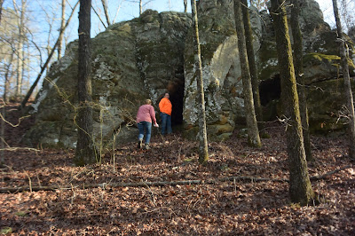
 We drove 3.61 miles along this logging road until we were blocked by a tree across the road. This point is the parking location listed above. From this point, it was less than a half mile to the jumble of very large rocks atop Evans Mountain that contained the cave. There is no indication of a cave opening from the top, so you have to go down to the 'front' of the rocks to the cave entrance. The cave itself is not large, maybe 30 feet in diameter, and about ten feet high in the center. There are numerous inscriptions and carvings on the rocks outside the cave, but time has weathered them to such an extent that I could not make out most of them.
 We hiked less than a mile round trip, so I would hesitate to even call it a hike. This was more like an off road adventure into an area we normally would not be able to easily access. The logging road fords across Jakes Creek twice and winds its way up Evans Mountain. The views from the top of the mountain are spectacular.
Files (.gpx format) - Map with GPS Tracks at bottom of this post
Logging road track up Evans Mountain
Hideout Cave track
 My hiking companions and I had already done two hikes today. We did a complete loop of Graves Creek canyon, then went over to Rough Falls for a quick trip to check on that waterfall. David and Amber had more than a two-hour drive home, so their hiking day was done. But I, along with friends Dan and Shelly Frew, had time for one more quick hike before calling it a day. It really is a blessing to be a 'local' and live close to these beautiful locations. On our way into the Graves Creek area, we had noticed that the forest service had left the gate into the road leading up Evans Mountain open, probably for deer hunting. Dan had hiked into this area long ago and knew of a cave high on top of the mountain, hidden amongst a large rock formation.
To get there, so north on Hwy 7 for 5.5 miles from the intersection of Highways 7 and 27 in Dover (Dover Supermarket) and turn left (west) on Hwy 164. Go 4.7 miles and turn right (north) on Pilot Rock Road. This is the first right after the double bridge over Piney Creek, about 0.5 miles from the end of the bridge. Go 1.8 miles on Pilot Rock Road and turn left on Jakes Creek Road. Instead of going down Jakes Creek Road, however, immediately turn left onto the Forest Service road at that intersection. It will have a gate on it, sometimes left open and sometimes not. You will need a vehicle with good clearance for this road, preferably a good 4WD.
 We drove 3.61 miles along this logging road until we were blocked by a tree across the road. This point is the parking location listed above. From this point, it was less than a half mile to the jumble of very large rocks atop Evans Mountain that contained the cave. There is no indication of a cave opening from the top, so you have to go down to the 'front' of the rocks to the cave entrance. The cave itself is not large, maybe 30 feet in diameter, and about ten feet high in the center. There are numerous inscriptions and carvings on the rocks outside the cave, but time has weathered them to such an extent that I could not make out most of them.
 We hiked less than a mile round trip, so I would hesitate to even call it a hike. This was more like an off road adventure into an area we normally would not be able to easily access. The logging road fords across Jakes Creek twice and winds its way up Evans Mountain. The views from the top of the mountain are spectacular.
  |
| GPS tracks for Hideout Cave black - logging road red - hiking route |
No comments:
Post a Comment