Tuesday, February 27, 2018

Wolf Creek and Left Fork Big Creek Caves and Waterfalls, Ozarks north of Cowell, Arkansas

2/27/2018 - Big Creek Cave Falls, Wolf Creek Cave Falls, more waterfalls, caves, and "Stuff you might find in the Ozarks"


GPS Coordinates:  Latitude/Longitude/Elevation
  Parking:  35.87684, -93.16071,  1162 feet
  Big Creek Cave Falls:  35.86318, -93.15447,  1294 feet
  Wolf Creek Cave Falls:  35.86063,  -93.15244,  1297 feet
  Underground Falls:  35.86074,  -93.15257,  1281 feet
  Cave Creek Cascade:  35.86384,  -93.15439,  1267 feet
  Mine shaft:  35.85954,  -93.15322,  1309 feet
  Unnamed Cave Falls:  35.85954,  -93.15350,  1300 feet
  Unnamed Wolf Creek Falls #1:  35.86265,  -93.15121,  1292 feet
  Unnamed Wolf Creek Falls #2:  35.86225,  -93.14889
  Unnamed Wolf Creek Falls #3:  35.86211,  -93.14881,  1425 ft.
  Turn off trail to Wolf Creek Falls #3:  35.86147,  -93.14929,  1408 ft.
  Turn off trail to Cave Creek Cascade:  35.86472,  -93.15319,  1239 feet
  Rock Peninsula Falls:  35.86666,  -93.15417,  1214 feet
  Turn off trail to Rock Peninsula Falls area:  35.86736,  -93.15412, 1223 feet
  Old homestead with antique car bodies:  35.86826,  -93.15399, 1260 feet

Pet friendly:  Yes, I usually take Boomer with me when I go here.  One word of caution - if your dog needs to stay on leash, it should be OK unless you venture off trail and do any significant bushwhacking.  There are a lot of briers and underbrush in this area.  Around the upper two waterfalls on Wolf Creek, Boomer struggled a little finding a way in and out, but he managed.

Motorcycle friendly:  Not really.  It is 2.8 miles down a marginal gravel road.  I would never take mine on it, but I know a lot of you riders don't see that as a challenge at all.  As one of my nephews puts it, "my driveway is longer and rougher than that."


Hiking Statistics:  We logged 4.25 miles round trip today, with a highest-to-lowest elevation change of 400 feet.  Our hike was cut short today by a thunderstorm; normally we wander around for well over six miles here, just exploring a little while hitting all the other stuff we already know we wanted to see.  I would rate this a moderate bushwhack.  Quite a bit of hiking is along old trace roads.  The only difficult bushwhacking is climbing up and down at creek level on Wolf Creek

GPS files (.gpx format) - Maps of the GPS track are at the bottom of this post.
  Big Creek Cave area waypoints
  Big Creek Cave and Wolf Creek GPS track for today's hike

Note - this post adds some new features I found on this hike.  Previous blog posts to the Big Creek Cave area:
  Feb 6, 2016
  Jan 27, 2015
  
Wolf Creek Falls #3
With all the recent rainfall after our extended drought, I have been torn on where to go.  After almost no rain for a half year, we finally got eight inches of rain over about a one week period.  Needless to say, the creeks, streams, and waterfalls are gushing.  I wanted to get out and see some of my favorites in all their glory, but I also wanted to go see some areas on my "wet weather" list that I still have not seen with a good amount of water flow.  I finally settled on one of my old favorites, the Big Creek Cave Falls area, because it has lots of cool stuff AND it has waterfalls on Wolf Creek that I still have not seen with decent water flow.  It was just me and Boomer (our German Shepherd) today, and with more rain threatening to blow in, we got out as early as we could and headed north.


Wolf Creek Cave Falls
To get there, go north on Highway 7 another 1.3 miles from the Highway 16 intersection going to Deer. Turn right onto NC-6840.  There is a one-story frame farmhouse here on the right and this looks like a couple of ruts going behind the guy's house as if it is his driveway.  It isn't.  It actually turns into a decent one-lane forest service gravel road. Go 2.8 miles from Highway 7 on this road and park on the right by a metal gate. The power line ends there at what was an old homestead years ago, one of at least three that I know of in the area. There is no trace of a house left, but there is a rock storm shelter remaining. There is a metal gate here across an old road leading past the homestead site and you can park in the small loop off the road by this gate.  Note that NC-6840 is the 'new' Newton County road number.  Old maps will have that as FR-1224 or CR-59, and it is sometimes referred to as Cowell Road.  NC-6840 is the only road sign you will see when turning off Highway 7.


Ford across Left Fork Big Creek
On a previous blog post, I detailed step-by-step hiking directions to the various features in this area.  I even included photos of the area at each major turn and section of the hike to get you over the field, across Left Fork Big Creek, and onto the old trace road.  I won't reiterate all that mass of detail, I'll just direct you to them at the link here. That's an awful lot of detail to copy and would just needlessly clutter this blog post.  One note here on my directions; this is one of the few hikes where I deviate from the route in Tim Ernst's Arkansas Waterfalls book.  This excellent book has been my hiking bible and was my guide for my first visit to the area, many years ago.  I have since used a much easier route that utilizes the old trace roads in the area.


Rock Peninsula Falls
Boomer and I hiked straight through, across the first creek you ford, which is Right Fork Big Creek, across the small field, across the big field, across the ford on Left Fork Big Creek, and then we took the trail along the left (east) side of the creek.  We detoured off to go to Rock Peninsula Falls and snap a couple of photos.    From there, we took an old trace that runs closest to the creek and runs into the trail we had been on.  We got a little surprise today in that it looks like erosion from the creek has caused a small landslide, and a section of this old road was completely gone, leaving a dropoff of about 20 feet to the creek below.  We could hike around the eroded area easily enough, but I'll just have to remember to stay on the main trail running along the east side of the creek in the future.


Wolf Creek Falls #1 - with Boomer
We continued hiking up the trail to where it crosses Wolf Creek, then we hiked upstream on Wolf Creek on the right (west) side until we got to Falls #1.  I had only seen this waterfall previously with a little dribble of flow, and today it looked great.  From there, I knew I wanted to go upstream to look for more waterfalls, and it appeared it was easier to go up through a break on the left (east) side of the waterfall.  Climbing up above Falls #1 and heading upstream, there is a tall, solid rock cliff on the east side, with the creek running very close to it.  Our hiking, therefore, was confined to the right (west) side of the creek, and it is very rugged with a steep slope and lots of huge rocks to maneuver around.  In the future, I'll be going in the opposite direction we did today; I'll explain later.

In addition to Wolf Creek Cave and Big Creek Cave, which are well known, there are a number of caves in the area, and some fairly big ones at that.  Because the others are not well known and are wild caves, I won't be sharing the location data for them.  I hate to leave the blog post incomplete, but because of the small fraction of people that just can't seem to go to fantastic places like this without leaving graffiti or removing and damaging artifacts, I'm not making public any location data for wild caves and sites I find that have any kind of historical or archeological significance.  Not ones that are not already well known, anyway.  I apologize and hate that the sins of the very few dictate measures like this, but there it is.


Wolf Creek Falls #2
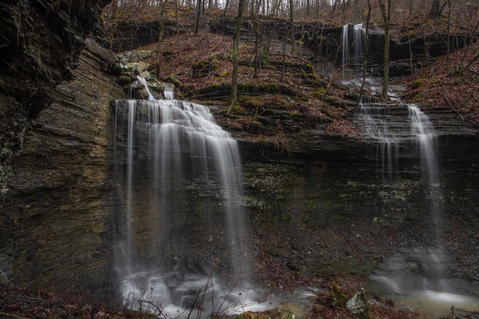
After climbing upstream to Falls #2, I thought that it was a little difficult to get to.  That was a walk in the park compared to Falls #3.  I could see the upper part of Falls #3 from Falls #2, so I was determined to get to it, and by climbing through some narrow cracks and over and around boulders, then climbing up the steep bluff and back down to the base of Falls #3, we finally got there.  It was worth it.  This waterfall reminds me a lot of Thunder Canyon Falls, one of my favorites.  It is about the same size and twists down a narrow chute.  Falls #3 has a big sentinal rock that splits the flow as it comes down, making the roar that much louder and making the waterfall that much prettier.  Wolf Creek has a lot of drainage area upstream and looks like it should have a lot of flow most of the year, but I know that is not the case.  That being said, when the wet weather does hit, this one should definitely be on your list to go see.


Wolf Creek Falls #3
Climbing back up the bluff to get out of the area below Falls #3, Boomer really struggled to find a path he could climb up the rocks to get to the steep earth slope above the creek.  Once he had dirt he could dig into, he was okay and I was the one trying to climb without slipping.  I was dreading hiking downstream on the very steep slope, so I stopped and took another look at the old Forest Service maps.  Sure enough, it indicated an old road running down the spur along the top of this slope.  We hiked up and around the spur a short distance and found it.  That made it much, much easier to hike down.  My recommendation would be to hike up this road to the point I marked in the GPS coordinates above, then cut over and drop right down to Falls #3.  It is much easier going up the road and then down the creek instead of vice versa.


Vehicle at the old homestead site
After taking the old trace road down the hill to where our trail had crossed Wolf Creek, we turned left and crossed Cove Branch to go upstream to Wolf Creek.  One of the things that have always bothered me is why Wolf Creek Cave is not on Wolf Creek, and why Big Creek Cave is not on Big Creek.  Big Creek Cave Falls runs into Cove Branch, near the junction with Wolf Creek, but at least all of this is in the larger Big Creek watershed.  Wolf Creek and Cove Branch flow together to form Left Fork Big Creek, which then flows into Big Creek itself.  I think somewhere along the way, someone got confused.  If you look on the really old USGS maps, what is now Cove Branch was labeled Wolf Creek, which makes sense then for Wolf Creek Cave Falls flowing into it.  What is now Wolf Creek was labeled "Cave Branch", which some drunk cartographer must have transcribed and mixed up as "Cove Branch".  That's my theory, anyway.


Wolf Creek Cave Falls
We went upstream on Cove Branch to Wolf Creek Cave with the skies getting very dark and ominous, so Boomer and I rushed through some photos.  Coming back down to where the creek from Wolf Creek Cave flows into the cave with Underground Falls, we stopped only long enough to snap a couple of photos and a video with my cell phone.  It was thundering and we felt a few raindrops, so I decided to cut the exploration short for today and just hit Big Creek Cave Falls on our way out.  By the time we hiked the short distance back downstream on Cove Branch to the drainage with Big Creek Cave Falls, it was starting to rain.  Thinking we might get lucky and it might blow over, I detoured over to Cave Creek Cave to see if we could wait it out.  


Big Creek Cave Falls 
Cave Creek Cave is the large shelter cave where the water from Big Creek Cave Falls that goes underground at the base of the falls comes back out of the ground.  While Boomer and I were taking refuge from the rain there, we had a pleasant surprise.  Kristin Jones and Harrison Sutcliffe, both of whom I had known only through social media, were also out in the area today and came up to the cave.  It is always great to meet folks I know of, but have never met in person, out in the wilderness.  Kristin had been watching the radar and informed me that this storm probably would not be blowing over.  We all decided to head back before it got too bad.  Boomer and I made a quick trip around the bluff to Big Creek Cave for a couple of photos, and Harrison and Kristin headed for the creek crossing and the old homestead with the old cars.  

Old Homestead site
Boomer and I also made a quick stop at the old homestead site, then went back to the lower trail and headed back as we had hiked out.  The rain had already made the lower trail much soggier than it had been on the way in.  We managed to get back to the FJ before the rain really started coming down, although we were soaked anyway.  All in all, it was a shorter trip to one of my favorite places, and I wish we could have had a few more hours to explore and not be in a rush, but I'm glad we got out and did the hike.  I was finally able to see Wolf Creek with enough flow to make the waterfalls on it look great, and Falls #3 is well worth the trip by itself.  This area has a lot to offer in a relatively small area and is always highly recommended.
Big Creek Cave Falls area - GPS track for today's hike

Sunday, February 25, 2018

Cub Creek Falls, Ozark National Forest near Cowell, Arkansas


2/25/2018 - Cub Creek Falls and bushwhack of the entire hollow.

GPS Coordinates: (Latitude, Longitude, Elevation)
  Parking for Cub Creek Falls:  35.80897   -93.15819,  2010 feet  
  Parking today (near southwest prong):  35.79420   -93.15346
  Cub Creek Falls:  35.80727   -93.15299,   1740 feet
  Falls #4:  35.80897   -93.15281
  Falls #5:  35.80727   -93.15305

Pet-Friendly: Yes.  Dogs on or off leash should be OK.  I didn't see any areas that most dogs couldn't navigate on their own.

Motorcycle Friendly: Yes.  The Parking location is almost a mile down a dirt road, but at this part of the road, it is usually pretty well maintained.

Hiking Statistics:  The hike to Cub Creek Falls is only about 0.6 miles each way, with an elevation change of 357 feet.  About half of that is along an old ATV trail.  I would rate this as a moderate bushwhack, just due to the moderate climb out and the brush is a little thick at the top of the waterfall to get to the bluffline break.  

GPS files:
    Pelsor - Deer area waypoints
    Cub Creek GPS track
    Lonesome Hollow GPS track
    Cub Hollow Polyfoss GPS track (eastern prongs)

Related Blog posts:
    Cub Creek Exploration
    Lonesome Hollow Falls
    Cub Hollow Polyfoss

Cub Creek Falls
A couple of months ago, I explored the entire valley that Cub Creek flows through, and while it is one of the prettiest places on earth, it was also pretty rugged terrain.  I didn't find Cub Creek Falls until I had almost come to the top of the creek and found that the hike out from there was not that bad.  I told myself I would come back, get some photos with decent water flow, and write a blog post just to get to this waterfall and back.  Since this is very close to where you park for Lonesome Hollow Falls, another easy bushwhack, I thought these two hikes would go very well together as back-to-back hikes.  I put links to blog posts for the adjacent areas above, and the Lonesome Hollow Falls hike is featured in Tim Ernst's excellent guidebook Arkansas Waterfalls, as the Cub Hollow waterfalls are. If you don't have this guidebook, I highly recommend you get it. The "Cub Hollow" waterfalls are in the eastern prongs of Cub Hollow, and Cub Creek Falls is in the long western prong, the main creek for the hollow.  

Falls #5
My hiking partner today was Boomer, our German Shepherd.  Since he tends to be very friendly and will "accidentally" knock over tripods and cameras, he doesn't get to go hiking when I hike with other photographer friends.  He also doesn't go with me when I explore new areas that could be too rugged for him.  There isn't much he can't handle, but if I get in a spot where I have to climb up rocks to get above or below a bluffline, he clearly can't do that.  Three or four feet is about the limit of his jumping ability, and he needs a running start for that.  He was looking a little forlorn about being left home, so I decided today would be a Boomer day.  We loaded up for the "Cowell trifecta" - Cub Creek Falls, Lonesome Hollow Falls, and Hudson Shelter Falls, and headed north.

Parking Location
To get there, from the Dover town square (intersection of Hwy 7 and Hwy 27), go 39.2 miles north on Highway 7 to the Cowell Cemetery on the left.  This is about 0.2 miles south of Cowell.  The cemetery is on the west side of Highway 7.  Take the road that loops around the back of the cemetery halfway around the cemetery, and take FR-1253 (aka NC-7120, or Taylor Ridge Road) south.  There are two dirt roads at this point; FR-1253 is the south-most of these, and has signs that say 'Dead End' and 'One Lane Road with Turnouts'.  Follow FR-1253 for 0.8 miles, bearing left to stay on FR-1253 at about 0.4 miles, and park on the left where an old trace road leads off.  

Cub Creek Falls
After you park, take the old trace road to the east.  This looks like it was used as an ATV trail at one time, but hasn't seen any use for quite a while.  Today, we could hear the roar of Cub Creek Falls as soon as we started down the trail.  This trail will lead you around the top of a steep side drainage just downstream from Cub Creek Falls, and then take you down to a point that you can bushwhack down to Cub Creek upstream of the waterfall.  About 0.2 miles down the ATV trail (1000 feet), it forks and a trace goes off to the left.  Bear right and keep going straight here, down the hill toward the creek.  The ATV trail kind of disappears but keep going downhill toward the creek.  

Falls #4
You will either get to the creek or hit another trace of an old ATV trail running just above the creek.  Either way, head downstream, to your right.  Hiking on the old ATV trail is easy, and if you got to the creek instead, there is less brush and easier hiking on the other side.  As you go downstream, there is a small but pretty waterfall, Falls #4.  You need to be on the east side before you get to Cub Creek Falls, so if you have not crossed the creek yet, go ahead and cross over at Falls #4.  The top of the waterfall slopes toward the dropoff and is slippery rock wherever it is wet, so don't try to cross too close to the edge.  On the east side of the waterfall (left as you go downstream), there is a bluffline break you can hike down and around to the base of the waterfall.  There isn't a bluffline break on the west side of the grotto that I could find, which is why you need to be on the east side of the creek.

Falls #5
After getting to Cub Creek Falls, we found another pleasant surprise.  When we were here in January, the Ozarks was still gripped by a very prolonged drought.  The drainage we hiked around on the ATV trail actually drains right into the grotto with Cub Creek Falls, and today it had pretty good flow, making Falls #5 where it spills over into the west side of the grotto.  Boomer and I hung out here for a while, enjoying the Natural State goodness.  Heading back out, we hiked back the way we had hiked in.  Back at the FJ, it was a very short drive, just 0.2 miles down the road, to the parking spot for Lonesome Hollow Falls and the second part of our Cowell trifecta.  I would recommend this hike for anyone that can handle a little off-trail action.  As bushwhacks go, this one is about as easy as Lonesome Hollow Falls, but is just a tad longer.
Blue - Cub Creek Falls track
Red - Lonesome Hollow track


Cub Creek Area GPS Tracks
Orange - Cub Creek Falls
Yellow - Lonesome Hollow Falls
Red - Cub Hollow Polyfoss Falls
Blue - Cub Creek Hollow

Friday, February 23, 2018

Grapevine Shelter waterfalls, Blue Hole Special Interest Area, Ozarks north of Hector, Arkansas

2/23/2018 - Grapevine Shelter Falls, other waterfalls in the Blue Hole SIA

GPS Coordinates:  (Latitude,  Longitude,  Elevation)
  Parking Location:  35.53732   -92.87910,  1479 ft.
  Falls #1:  35.53247   -92.88207, 1140 ft
  Falls #2:  35.53264   -92.88230,  1168 ft
  Grapevine Shelter Falls:  35.53197   -92.88488,  1165 ft
  Falls #4:  35.53180   -92.88478,  1147 ft
  Falls #5:  35.53064   -92.88563,  1145 ft
  Falls #6:  35.53057   -92.88554,  1134 ft
  Falls #7:  35.53027   -92.88443,  1053 ft
  Falls #8:  35.53060  -92.88441,  1053 ft
  Falls #9:  35.52804   -92.88410,  972 ft

Pet-Friendly:  Dogs off leash should be okay.  Dogs on a leash are always difficult in bushwhacking areas, but it can be done.  

Motorcycle Friendly:  No. Parking is off Lindsey Mountain Motorway.  This is a not-so-good dirt road many miles down other dirt roads.  Not recommended for street bikes and cruisers.


Hiking Statistics:  From top to bottom, the Blue Hole SIA is about 1000 feet of elevation change.  Today, we hiked 2.1 miles with a "highest to lowest" elevation change of 461 feet.  Roughly half of the hiking was along an ATV trail, which is fairly easy.  Probably half was what I would call a moderately difficult bushwhack.  We were hiking for 2 hours and 15 minutes on the track at the bottom of this post.

GPS files (.gpx format) - Maps of the GPS track are at the bottom of this post.
  Blue Hole Special Interest Area Waypoints
  Grapevine Shelter waterfalls GPS track

Blog posts for nearby areas:
  Sand Cave Hollow polyfoss
  Wolf Den Hollow
  Grapevine Shelter, Blue Hole Falls, and Green Grotto Falls
  Hurricane Creek


Grapevine Shelter Falls
with (L-R) Rick, David, and Dan
The Blue Hole area is what is called a "Special Interest Area" (SIA).  There are a plethora of Land Management "area" designations, and this one is supposed to be for areas that have some special characteristic that gives it unusual scientific or recreational value.   The Blue Hole SIA is well known for the Blue Hole Cascades, that you can drive a good 4WD or ATV right down to.  These two waterfalls always get some ooohs and aaaahs, but rarely does anyone even venture into the other parts of this SIA, which in my mind have much more awe-inspiring waterfalls and other features.  The Grapevine Shelter is one of those, perched about halfway down Grapevine Mountain.  Today, it was supposed to start raining mid-morning and come down heavy all day, but Dan Frew, David Dedman, and I thought we could get in a quick hike to this area before the rain started.  We met up early in Dover for breakfast and got started.


Pedestal Rock near Falls #2
To get to the parking location, drive north from Hector on Highway 27.  Less than a mile from the Big Piney Ranger station in Hector, you cross over Dare Creek.  Immediately after crossing Dare Creek, turn right onto White Oak Mountain Road (aka FR-1301).  This is a gravel road but is a well-traveled and fairly well-maintained road.  Go 11.4 miles on White Oak Mountain Road.  Be careful 7.2 miles from Highway 27 and bear left where the road branches at the 'Y' in the road.  After following White Oak Mountain Road for 11.4 miles, turn left onto Lindsey Mountain Motorway.  Go 1.8 miles, then turn down the Jeep road on the left and park.  


Falls #1
We started our hike down the Jeep road, but only for a short distance.  As soon as we neared the top of the drainage to our left, we veered off the road to the left (south) and bushwhacked down into the drainage.  Falls #1 and Falls #2 are below the major bluffline on Grapevine Mountain on this drainage.  From there, instead of following the creek downstream, we followed the bluff around to our right (west) for a little less than a quarter mile.   Grapevine Shelter is about the same elevation as those first two waterfalls we found, in a small side drainage to the west.  This is a large shelter-type cave that Dan had found in an earlier hike in the area.  This one happens to have a unique crag over the top that also guides a very tall waterfall flowing right over the front of the mouth of the cave.  I had been here before, but the waterfall is definitely a wet weather one, and we wanted to see it after the six inches of rain that had dropped on the area the last few days.    This cave was apparently used by someone in the past.  There is a rock with something the dirt dobbers have covered up and the date "September 1922".

Waterfall in the back of Grapevine Shelter
We spent a good deal of time at Grapevine Shelter.  Not just because it is awesome, which it is, but just like on my previous visit here, we actually used it as a shelter.  It had been raining off and on, and it was nice to have a dry location to go to when the rain started coming down.  I have done scaling with a photo of Grapevine Shelter Falls and found it to be 46 feet tall.  Today, there was actually a waterfall coming out of a hole in the back of this very large cave.  What a cool camping spot, eh?  A large, roomy shelter with running water.  I noticed something else different as well - some inconsiderate jerk had taken a felt tip pen and written on one of the rocks.  I couldn't tell what, but just seeing it aggravates me.  Why do people feel the need to come to places like this and ruin it for the rest of us?  This kind of stuff makes me seriously ponder on whether I should be giving directions to everyone on how to find these places.  If the problem persists, I'll keep writing for myself, but I will no longer publish them for the public at large.  


Grapevine Shelter Falls, inside out
Okay, rant over, I feel better for venting.  But remember the prime directive, people - Leave no trace.  We prefer our wilderness pristine.  Just downstream, the creek seems to run right into some large boulders.  There is actually another small cave here, with Falls #4 falling right inside it.  The pool Falls #4 falls into takes most of the room inside, and the creek runs out under the rocks in the back.  Today, the flow was so great that we could not get into the side cave for a shot of the waterfall inside.Leaving Grapevine Shelter, we continued around the bluff.  There is another drainage further around the bluff another hundred yards or so coming off Grapevine Mountain.  


Falls #2
This little drainage on the side of Grapevine Mountain has scads of nice waterfalls.  Falls #5 and Falls #6 are on the same bluffline as Grapevine Shelter Falls and the creeks from both flow together downstream.  Both Falls #7 and Falls #8 are approximately a hundred yards downstream at the junction of these creeks.   The creek downstream of Falls #1 and Falls #2 likewise flows into this creek, with Falls #9 on this combined Grapevine Mountain creek 200 yards from that junction.  The Grapevine Mountain Creek continues on for a quarter mile more before flowing into Hurricane Creek.  See the map at the bottom of this post for reference.

Cascade below Falls #2
The last time I came through here, we continued on hiking down to the two Blue Hole Falls that make up Blue Hole Cascades, then a larger loop up into Wolf Den Hollow and Green Grotto Falls.  Today, however, we didn't want to get too far from the vehicles.  We headed up the bluff from Falls #6 and climbed up to the ATV trail, then hiked that back to the parking location.  The slope out on this end of Grapevine Mountain is not quite as steep as the slope we descended on, but it is still a climb of more than a couple of hundred feet.  Once on the ATV trail, it is easy hiking, mostly on the level.  I would rate this as a moderate bushwhack, just for the moderate climb at the end.  This time of year, the undergrowth is not that much of a problem.  This one in the bag, we headed over to the Sand Cave Hollow waterfalls to see if we could press our luck on the rain.
Grapevine Mountain GPS track


Sand Cave Hollow waterfalls, Ozarks north of Hector, Arkansas

2/24/2018 - Sand Cave Hollow polyfoss

GPS Coordinates:  (Latitude,  Longitude,  Elevation)
  Parking Location (Waterfalls):  35.54853   -92.89040,  1373 ft
  Parking Location (Sand Cave):  35.54491   -92.90199,  1100 ft
  Sand Cave:  35.54430,  -92.90148,  1059 ft
  Falls #1:  35.54135   -92.90110,  881 ft.
  Falls #2:  35.54208   -92.89472,  1032 ft.
  Sand Cave Falls:  35.54114   -92.89268,  1126 ft.
  Falls #4:  35.54131   -92.89254,  1142 ft.
  Sand Cave Quintuple Falls:  35.54121   -92.89229,  1202 ft.
  Falls #10:  35.54677   -92.89185,  1195 ft.
  Falls #11:  35.54173   -92.89254, ll543 ft.
  Falls #12:  35.54157   -92.89266
  Falls #13:  35.54138   -92.89294, 1032 ft.

Pet-Friendly:  Dogs off leash should be okay.  Dogs on leash will make it difficult to access many of these areas, but could be done.  Note that it is fairly steep getting down into and out of the grotto for Sand Cave Hollow Falls.

Motorcycle Friendly:  No. Parking is off Lindsey Mountain Motorway.  This is a not-so-good dirt road many miles down other dirt roads.  Not recommended for street bikes and cruisers.

Hiking Statistics:  From top to bottom, the Blue Hole SIA is about 1000 feet of elevation change.  Today, we hiked 1.85 miles with a highest to lowest elevation change of only 385 feet.  This was all bushwhacking, although there is an old trace road we could follow most of the way.  Overall I would call this a moderate bushwhack.  We were hiking for 2 hours and 8 minutes on the track at the bottom of this post.

GPS files (.gpx format) - Maps of the GPS track are at the bottom of this post.
  Today's track to Quintuple Falls and Sand Cave Hollow Falls

Previous hikes into Sand Cave Hollow:
Sand  Cave Hollow Falls
When we visited Sand Cave Hollow for the first time in March of 2017, we found a pretty spectacular area in the upper end of the hollow.  After almost giving up on finding anything, we found the beautiful waterfall we named Sand Cave Hollow Falls, then six more waterfalls above it, including five so close together I just called them Quintuple Falls as a group.  This was another of those areas we vowed to come back to, so we could see them after things "greened up" a bit, and hopefully with more water flowing in the creek.  Well, we did, a couple of months later when it was fairly wet and there was foliage on the trees.  Unfortunately, we learned another lesson.  Not only do you need wet weather to see this polyfoss in all it's glory, if the trees are all "greened up", you can see it by moving around but your camera can't see many of the waterfalls from the same spot because of the foliage.  So, back on the "wet weather go-to" list it went.  Today, after some heavy rains this week, we decided to give it another shot, hoping to get in and out of the area between rains.  My hiking companions today were Dan Frew and David Dedman.

Falls #11
To get there, drive north from Hector on Highway 27.  Less than a mile from the Big Piney Ranger station in Hector, you cross over Dare Creek.  Immediately after crossing Dare Creek, turn right onto White Oak Mountain Road (aka FR-1301).  This is a gravel road but is a well traveled and fairly well-maintained road.  Go 11.4 miles on White Oak Mountain Road.  Be careful 7.2 miles from Highway 27 and bear left where the road branches at the 'Y' in the road.  After following White Oak Mountain Road for 11.4 miles, turn left onto Lindsey Mountain Motorway.  Go 2.9 miles and park on the left.  
Quintuple Falls

One of the reasons I decided to write this blog was to keep track of my various explorations and learn from them.  Ideally, every time I go to an area I will find something that will help me the next time I visit the area.  This blog also helps me pass that information on to others.  On our first hike in Sand Cave Hollow,  I noted that the waterfalls that were worth the trek were all in the upper part of the hollow, and that we could get to that area directly from Lindsey Mountain Motorway fairly easily.  We also noted that we could park at a point on Lindsey Mountain Motorway at about the same elevation as the polyfoss, eliminating a climb in elevation at the end.  When we tried that, we learned another lesson;  the brush is really dense along the road at that elevation, but not along the road higher up, a half mile to the east.  The parking location noted above will have an additional climb of about a hundred feet, but is a much easier hike.

Falls #10
Today, I think we had the lay of the land all figured out and it turned out to be an optimal way in and out of this fantastic concentration of waterfalls.  We started out heading directly to Falls #10 and hit the old trace road that goes along the top of the drainages, then followed it to the top of the north prong in Sand Hollow.  Falls #10 is just below the old road, a short detour and very small climb into and out of the upper part of this prong.  The water flow was the best I had seen in three visits here, and it was definitely "photo-worthy".  We took some photos, got back on the old trace road, and continued around the east end of Sand Cave Hollow.

Falls #13
The old trace road has some minor undergrowth and downed trees, but is still much easier hiking than trekking through the woods.  It goes mostly on the level around the hollow and into the east prong, where the polyfoss is.  Just before getting there, we crossed another drainage that only had a trickle in it on previous visits, but today had a good amount of flow and three additional waterfalls.  The lowest of these, Falls #13, is over 20 feet tall and spills into the main creek very close to the base of Sand Cave Hollow Falls.  We went from Falls #11 to Falls #12, then down all the way to the creek.  The break to get down to the creek below Falls #13 is very steep, but do-able.  Other than hiking the creek all the way from the outlet, which we certainly did not want to do, this was the only way to get into and out of the grotto with Falls #13 and Sand Cave Hollow Falls.

Falls #4 (foreground)
Sand Cave Hollow Falls was really gushing today.  With water hitting the grotto from multiple waterfalls, it was creating quite a mist and I had a hard time keeping the camera lens dry.  From Sand Cave Hollow Falls, we climbed up the steep access just downstream of Falls #13, then over across the drainage at the top of Falls #13, and upstream a few yards to Falls #4, yet another really nice waterfall.  The climb above Falls #4 is easier, and that puts you right at the base level for the lower tier of Sand Cave Quintuple Falls.  There is one "full height" waterfall on the left, then in the center and right side there are two tiers of waterfalls, making five in total.  It is truely a spectacular sight, one I highly recommend you experience in person.

Quintuple Falls
While all five are grouped together here, and make a stunning visual for the human eye, my camera's eye is not nearly that good.  Dan and David both had wider angle lens than I did, but even with that, I don't think any camera can fully convey the sights and sounds of this area.  We spent quite a bit of time in the Quintuple Falls area, taking photos and videos, all of which look great.  That being said, it is one of those areas that you really need to go to for the full experience.  I will be getting an 11mm Tokina lens for my D500, but believe me, it still won't convey how fantastic this area is.

Quintuple Falls
We finally got our fill of the Quintuple Falls experience and headed back.  From the leftmost of the Quintuple Falls (the single tier one), you can follow the base of the bluff at the bottom of the waterfall up and around to the left to climb to the top of the bluff.  This is the level that old trace road runs at, and we soon came to it and started hiking back the way we came.  As you can see from the map below, we did veer off the old road before getting to Falls #10.  There was very little undergrowth bushwhacking back this way, and the slope was much lower, providing a gradual climb back up to the elevation of Lindsay Mountain Motorway.  As I mentioned before, I think we have our route for this hike wired now.  Despite some occasional steep and slippery parts such as getting to the base of Sand Cave Hollow Falls, it is not that difficult as bushwhacks go.  I would rate it as a moderate bushwhack.  Even though I have seen this three times now, I'm certain I'll be back to show friends this spot.
Sand Cave Hollow
Red - 3-17-2017 GPS track of entire hollow
Blue - 2-23-2018 GPS track to polyfoss area only

Schoolhouse Falls, Ozarks near Hector, Arkansas

2/23/2018 - Schoolhouse Falls

GPS Coordinates:  (Latitude,  Longitude,  Elevation)
  Austin Trailhead:  35.53615   -92.80366,  1516 ft.
  Parking Location:  35.53000   -92.80261,  1434 ft
  Schoolhouse Falls:  35.53019   -92.79877,  1273 ft

Pet Friendly: Yes.  No problem for dogs off leash.  

Motorcycle Friendly: No.  It is about 15 miles on a gravel road, no place for a heavy cruiser or touring bike.

Hiking Statistics:  The hike to Schoolhouse Falls is less than a half mile each way, with an elevation change of only 180 feet.  Most of the hike is along an ATV trail, the rest is on a volunteer trail.  I would rate this as an easy hike.  Of course, this is from where we parked today.  If you park further up the road toward the Austin Trailhead, your hike will be that much further.

GPS files:

    Pelsor - Deer area waypoints
    Schoolhouse Falls GPS track

Nearby areas:
    Lizard Log Falls
    Ladderbucket and John Mountain Falls

Schoolhouse Falls
Today was a day for short hikes and dodging the rain.  My hiking companions today were Dan Frew and David Dedman.  We had met in Dover early this morning, thinking that if we were lucky we could get in a hike to Grapevine Shelter Falls.  We wanted to see it in all the glory that the 6+ inches of rain we had received the last few days could provide.  We did that hike, and with only an occasional light rain to deal with, we decided to hike the nearby Sand Cave Hollow polyfoss.  After that, our luck was still holding, so we decided Schoolhouse Falls was another one that we could get to and get out fast should the monsoon we were promised arrive.  

Sign at 'Y' in White Oak
Mountain Road - bear left
To get there, drive north from Hector on Highway 27.  Less than a mile from the Big Piney Ranger station in Hector, you cross over Dare Creek.  Look upstream when you cross and you will see a nice little waterfall.  Immediately after crossing Dare Creek, turn right onto White Oak Mountain Road (aka FR-1301).  This is a gravel road but is a well-traveled and fairly well-maintained road.  Go 11.7 miles on White Oak Mountain Road.  Be careful 7.2 miles from Highway 27 and bear left where the road branches at the 'Y' in the road.  See the sign at right - you want to stay on White Oak Mountain Road at this point.  After following it for 11.8 miles, turn right onto Wilderness Trail (aka FR-1307).  Go another 3.3 miles and turn right onto a dirt road, FR-1338.  If you get to Jobe's Way, you have gone just a little too far.  Where you turned off Wilderness Way onto the dirt road is the Austin Trailhead.  Go down the dirt road for 0.3 miles and turn left onto an ATV trail.  I say ATV trail, but it has been widened recently and it's possible a Jeep might fit down it all the way to the creek.  I'm pretty sure my FJ is a little too wide to fit, but you can proceed at your own risk.  It isn't much of a hike, anyway, so no need to take chances.  We parked at a clearing that had been used as a campsite. This is the parking location I listed coordinates for above. 

Upper Schoolhouse Falls
Schoolhouse Falls is directly below in the hollow, and the ATV trail will take you all the way down to the creek. This is part of the Brock Creek Recreation Area, so there are ATV and single-track trails all over the place.  The hike starts out on the level, then gradually gets steeper as you get down into the creek canyon below.   Where the ATV trail crosses the creek, we crossed the creek as well, and there is a volunteer trail alongside the creek.  We took that and hiked downstream.  Schoolhouse Falls is a short distance, less than 50 yards, downstream of the trail crossing.  Along the way, you pass a smaller upper waterfall just upstream of the top of Schoolhouse Falls.

Schoolhouse Creek, from behind the waterfall
Continuing downstream, you will notice a bear crack leading down from the trail to below the bluffline.  I usually jump at any bluffline break I can find, so the temptation is to drop down through it to get to the base of the waterfall.  You really don't need to, however.  If you continue on down the bluffline, in just a few yards it slopes down to the creek level and you can go around and back up into the waterfall grotto without any climbing.  The weather was holding out, so we stayed a while and enjoyed the scenery while getting some photos.

Schoolhouse Falls
Schoolhouse Falls is one of a number of waterfalls in the Brock Creek Recreation Area.  The area is popular with hunters, mountain bikers, and ATV riders, as well as fellow waterfall chasers.  You see the hiking and ATV trails all over this fairly large area.  Down in the actual steep hollows, however, all you generally see is nature and the occasional waterfall chaser.  This is such a beautiful waterfall, yet so easy to get to, that you will wonder why no one else is there.  Today, of course, it was supposed to rain heavily all day, so only demented people like us were there.  Well, okay, just us and no other crazy people today.
Blue - Schoolhouse Falls GPS track
Red - Lizard Log Falls GPS track
Orange - Brushy Creek GPS track