Saturday, December 15, 2018

Bailey Cole Creek, Falling Water Road area, Ozarks near Ben Hur, Arkansas

12-15-2018 Bailey Cole Creek

GPS Coordinates:  (Latitude,  Longitude,  Elevation)

  Parking Location:  35.74158  -92.93337,  1258 ft.
  Bailey Cole Creek Falls #1:  35.73691  -92.92531 
  Bailey Cole Creek Falls #2:  35.73690  -92.92516
  Bailey Cole Creek Falls #3:  35.73664  -92.92459
  Bailey Cole Creek Falls #4:  35.73848  -92.92303
  Bailey Cole Creek Falls #5:  35.73868  -92.92486
  Bailey Cole Creek Falls #6:  35.74086  -92.91884
  Bailey Cole Creek Falls #7:  35.74076  -92.91837


Pet-Friendly: Dogs off leash should be OK.  This is a bushwhack all the way and you have to cross Falling Water Creek, which can be fairly challenging after a good rain. 

Hiking Statistics:  This is another hike without a lot of elevation change.  That being said, you do have to cross Falling Water Creek and will cross the creek in this drainage several times.  It was 3.43 miles round trip, with a minimum-to-maximum elevation change of only 271 feet.  I would rate this a moderate bushwhack.  If the creek is as high as it was today you'll be hiking with wet feet, if that adds any difficulty factor for you.

GPS files (.gpx format) - See maps at the bottom of this blog post
  Falling Water Creek area waypoints
  Bailey Cole Creek track
  
Links to blog posts for other nearby areas:

Along Bailey Cole Creek
We got a fair amount of rain over the last couple of days, and I figured I needed to get out someplace new.  There are a couple of hollows north of Falling Water Falls that my friend Dan Frew hiked a few months ago that I have been meaning to hike ever since.  I went to one of those, the unnamed hollow containing Bailey Falls, last month.  Unfortunately, I had a little camera disaster and Boomer was unable to climb the rocks to get up through one of the bluffline breaks, so we made it to Bailey Falls but I called it a day after that and went back the way we had come.  Today, I left Boomer at home to supervise Bethany doing all the Christmas decorating.  Our house looks like a veritable Christmas explosion took place.  I love it, but my decorating skills are severely limited, so I helped by getting out of the way.

The first of these hollows is the drainage containing Bailey Cole Creek, a fairly good sized hollow for this area.  The second is an unnamed hollow with an unnamed creek but has a nice waterfall called Bailey Falls.  So, to be clear, Bailey Falls is NOT on Bailey Cole Creek or even in the same drainage.  Both drainages run adjacent to each other, draining into Falling Water Creek.  To make things a little more confusing, there is another Bailey Cole Creek.  The headwaters for the two creeks are less than a mile apart, with one flowing north of Highway 16 into Falling Water Creek and the other flowing south of Highway 16 into the Middle Fork Illinois Bayou.  So, to be clear AGAIN, we are talking only about the Bailey (whoever that was) stuff in the Falling Water Creek area.  

Parking Location
Getting to today's parking location is easy.  From Pelsor (Sand Gap), go 9.9 miles east on Highway 16, through the small community of Ben Hur, and turn left (north) on Falling Water Road.  This is the first left after going through Ben Hur.  You'll pass a sign for the Piney Creek WMA on the right, and there is a sign here that says "Garrison Falling Water Horse Camp". Go 4.5 miles on Falling Water Road and turn onto the dirt road on the right.  It goes down to a campsite along Falling Water Creek.  The road leading into the campsite is very rough, but it's also very short;  I think most vehicles will be OK on it.  Park at the campsite.  This is midway between Falling Water Falls and the low water bridge downstream. It is about 2.2 miles past Falling Water Falls.  No one was at Falling Water Falls when I went past it, so I stopped for the quick obligatory snapshot.

Along Bailey Cole Creek
From the parking location, you can see where the dirt road you were on goes to a horse trail that crosses the creek here.  Cross Falling Water Creek and get on the horse trail.  That's easier said than done, today.  The recent rains had brought the level up in Falling Water Creek and it was now running almost three feet at the deepest point here.  Of course, it didn't look that deep and figured surely it wouldn't be deeper than the creek waders I had used just a month ago when going to Bailey Falls.  Those waders only go up the crotch, so they were unfortunately just a tad short.  I took on some water in both legs and scurried across as fast as I could.  Not that easy to scurry when wearing waders.  The good news is, for this hike, crossing Falling Water Creek is about the biggest challenge.  

Horse Trail Junction
After getting to the other side, I took the waders off and assessed the damage.  One foot was still remarkably dry, but the other boot was pretty much full of water.  I drained the boot, put a dry sock on my left foot, and stashed the creek waders behind a tree for my return trip back across Falling Water Creek.  From here, just follow the horse trail.  It will lead to a junction, where the horse camp folks have kindly put up signs to point to Purdy Hollow or to Bailey Falls.  I have never heard of Purdy Hollow, and it doesn't make sense they would call it that when Bailey Cole Creek is the name of the creek running through the hollow.  Although this could be just another thing the map makers have screwed up, which would also explain why there are two "Bailey Cole Creeks" so close to each other.  In any case, we'll hike over to Bailey Falls later.  To get to the Bailey Cole Creek drainage, go toward "Purdy Hollow".

Falls #2
The horse trail runs close to Bailey Cole Creek, and with normal water levels would be a really pleasant hike through a part of the area most folks don't ever see.   Today, the creek was running pretty clear, but fast and deep for what you might expect in a hollow like this.  There are quite a few places the trail crosses the creek.  Since I wanted to explore the whole area, I broke away from the trail anyway and headed up into the first side drainage with decent flow.  Falls #1 and Falls #2 were a little over a quarter mile up this drainage, and above Falls #2 a short distance was Falls #3.  By now, this drainage was getting to the point where any waterfalls I found above wouldn't have much flow anyway, so I moved on and climbed up on the bluff alongside it.

Falls #4
I looked at the topo map on my phone and noted that the next drainage should have a decent amount of water.  Instead of going all the way down this drainage and then up the next one, I opted to just cut across to the upper part of the bluff separating them and hike down the next one.  This drainage had only a couple of small waterfalls I considered photo-worthy, but you just never know what will be in one of these hollows until you check it out.  Getting back to Bailey Cole Creek, I headed on upstream.  This is where I needed to cross the main creek several times, which was a little tricky with the water being so high.  I did the rock-hopping thing as well as I could, trying to keep in water below the top of my boots.  It was, however, much deeper and much faster than it looked.  I ended up slipping on rocks a couple of times and going face down into the creek a couple of times and finally gave up.  One of the advantages of hiking alone is that no one sees you when you act like a complete idiot.  

Falls #7
At any rate, as much as I hate hiking with water sloshing in my boots, I finally accepted that it was going to be a wet feet kind of day and it was much easier after that.  My feet were cold, but at least now I could stick to the horse trail and just wade across where the trail crossed.  At the next side drainage, you could see the beautiful series of cascades that I called Falls #6 from the main creek, and Falls #7 was visible above it, pouring off a bluff into a pool behind a large boulder.  Climbing up along the cascading creek, I noticed that the large boulder had broken off the bluff above and had landed right over a small waterfall.  You could see and hear the waterfall through a gap in the rock.  Above this boulder was Falls #7, a classic Ozarks waterfall spilling off the bluff into a pool before feeding the waterfall under the boulder.

Falls #6
From Falls #6 and #7, I went upstream along the main creek for a way but stopped short of the major fork for Bailey Cole Creek.  The creek was still flowing well at this point, and the Forest Service maps show it as a year-round creek much further up into the drainage.  But it was already mid-afternoon, and I did want to hike the horse trail up to Bailey Falls today.  So at this point, I turned back and followed the horse trail all the way back down to the junction that takes you over to the small hollow containing Bailey Falls.  It was a fairly quick hike since I didn't concern myself with keeping my boots dry.  I'll come back and explore the rest of this hollow.   The lower half of this hollow didn't contain a whole lot of waterfalls, nor any that were particularly notable, but it was a really scenic chunk of wilderness that isn't often seen.  I'll come back and check out the upper part of this hollow.  For now, I was heading over to Bailey Falls via the horse trail.  
Orange - Bailey Cole Creek track
Red - Bailey Hollow track from Falling Water Creek
Blue - Bailey Hollow track from horse trail


Friday, November 9, 2018

Bailey Falls - bushwhack route, Ozarks near Ben Hur, Arkansas


11-09-2018 Bailey Falls

GPS Coordinates:  (Latitude,  Longitude,  Elevation)

  Parking for Bailey Falls:  35.73473  -92.93368,  1258 ft.
  Bailey Falls:  35.72905,  -92.92902, 1332 ft.
  Bailey UNF #1:  35.72995,  -92.92916,  1332 ft.
  
Pet-Friendly: Dogs off leash should be OK.  This is a bushwhack all the way and you have to cross Falling Water Creek, which will have a lot of flow when there is enough for Bailey Falls to look good.

Hiking Statistics:  This is a short hike without a lot of elevation change.  That being said, you do have to cross Falling Water Creek and will cross the creek in this drainage several times.  It was only 1.3 miles round trip to Bailey Falls, with a minimum-to-maximum elevation change of only 220 feet.  I would rate this an easy to moderate hike.  

GPS files (.gpx format) - See maps at the bottom of this blog post
  Falling Water Creek area waypoints
  Bailey Falls track
  
Links to blog posts for other nearby areas:
  Bailey Falls - horse trail route
  Bailey Cole Creek

Baily Falls
The Falling Water Creek area is one of the most prolific polyfoss areas in the world.  As you can see from the links to blog posts in the area, there are about a bazillion of them that I have hiked and made blog posts for.  Some are featured in Tim Ernst's excellent guidebook, Arkansas Waterfalls.  This guidebook is what got me started chasing waterfalls many years ago, and is highly recommended.  Many of the waterfalls in this area are not featured in the guidebook, and it seems like every little drainage has a nice waterfall or two, or sometimes a dozen.  Of course, you drive right by Falling Water Falls on the way to the parking location as well.  There are a couple of hollows north of Falling Water Falls that my friend Dan Frew hiked a few months ago that I have been meaning to hike ever since and finally headed out to today.  Boomer (our German Shepherd) and I got a late start, but finally got going.  We stopped to help a couple of teenagers with a flat tire which delayed us even more but did make me feel better.

Bailey Cole Falls
The first of these hollows is the drainage containing Bailey Cole Creek, a fairly good sized hollow for this area.  The second is an unnamed hollow with an unnamed creek but has a nice waterfall called Bailey Falls.  So, to be clear, Bailey Falls is NOT on Bailey Cole Creek or even in the same drainage.  Both drainages run adjacent to each other, draining into Falling Water Creek.  To make things a little more confusing, there is another Bailey Cole Creek.  The headwaters for the two creeks are less than a mile apart, with one flowing north of Highway 16 into Falling Water Creek and the other flowing south of Highway 16 into the Middle Fork Illinois Bayou.  So, to be clear AGAIN, we are talking only about the Bailey (whoever that was) stuff in the Falling Water Creek area. 

Parking location off Falling Water Road
As it turns out, due to an unfortunate mishap with my camera I only hiked up to Bailey Falls and back.  I'll get back to the rest of these hollows soon.  Getting to the parking location is straightforward.  From Pelsor (Sand Gap), go 9.9 miles east on Highway 16, through the small community of Ben Hur, and turn left (north) on Falling Water Road.  This is the first left after going through Ben Hur, and there is a sign here that says "Garrison Falling Water Horse Camp". Go 4.0 miles on Falling Water Road and park at the campsite on the right, next to Falling Water Creek.  This is midway between Falling Water Falls and the low water bridge downstream.  The drainage containing Bailey Falls flows into the other side of Falling Water Creek just upstream of the campsite.

New Waders!
I crossed Falling Water Creek upstream of the creek junction, and even in the widest spot I could find, it was still fairly fast and too deep to cross without wading.  Today, I was trying out some creek waders that my friend Dan Breedlove had recommended.  They cover the entire leg, have good traction, and are very inexpensive ($14.95 on Amazon).  I had previously used large garbage bags I fondly refer to as "Rick's redneck creek waders", but these are much better and hold up for more than one use.  The creek was knee deep and fast moving, and the new waders worked great.  On the other side, I put them in my pack.  They collapse down and are very compact and light.  

Unnamed Falls #1
Hiking upstream, there is an old trace road that crosses the creek a couple of times but runs mostly on the right side as you face upstream.  I had to cross the creek a handful of times, but overall this bushwhack is pretty easy.  About a mile upstream from the confluence with Falling Water Creek, you come to Falls #1 in a side drainage.  This is where things started going south for me.  I set up and took a shot of Falls #1, then when I moved with the tripod and camera to a different perspective, both boots hit incredibly slick rocks and down I went.  As I fell, the tripod snagged a tree root and the camera came down hard on a rock, right on the ND filter I had on the lens.  The filter was crimped onto the lens threads from being bent on impact, and I couldn't budge it.  Dang.  

Oops
Now my Samsung S8 Active was my only camera, but I was determined to finish hiking this hollow.  Boomer and I hiked to Bailey Falls, only about 150 yards further upstream.  It is a nice waterfall, about 12 feet tall, with a somewhat unique geometry on the main creek in this little hollow.  Today, it was still flowing quite well from the heavy rains more than a week ago.  We hung out at Bailey Falls for a while, doing what I could with a phone camera, then started upstream.  I found a bluffline break that I could climb through easily enough, but there was a jump of about four feet that Boomer just couldn't make.  

Bailey Falls
We probably could have found another way above the bluff downstream a bit, but this was the last straw on what had become a day filled with delays.  I still had to get home in time to get cleaned up and take Bethany out for date night, so I decided to call it a day and come back out another day with a working camera.  Hiking back downstream was easy, and getting the creek waders out and cross Falling Water Creek worked really well again.  Boomer had to swim part of the crossing and got swept downstream a little, but he loves that stuff.  We loaded up in the FJ and headed for home, vowing to come back for another shot at this great little area.
GPS track for Bailey Falls hike

Thursday, November 1, 2018

Pam's Grotto, Hwy 123, Car Wash, and Haw Creek Falls, Arkansas Ozarks near Fort Douglas

11-01-2018 Pam's Grotto Falls, Highway 123 Falls, Haw Creek Falls, Car Wash Falls

GPS Coordinates:  (Latitude,  Longitude,  Elevation)

    Pam's Grotto Falls: 35.68330, -93.25539,  1035 ft.
    Parking for Pam's Grotto: 35.67971, -93.25214,  769 ft.
    Highway 123 Falls: 35.61908, -93.29014, 808 ft.
    Parking for Highway 123 Falls:  35.61949, -93.29160, 721 ft.
    Car Wash Falls:  35.70529, -93.25474
    Libsheebum Falls:  35.65430,  -93.28550
    Haw Creek Falls:  35.67782, -93.25520

Pet-Friendly: Dogs off leash should be OK.  If your dog needs to be on a leash, it will work but will get a little tiresome when you are scrambling over rocks as you approach the grotto.

Hiking Statistics:  Highway 123 Falls is about a hundred yards from the highway, so it isn't much of a hike, only about 110 yards, and 87 feet elevation change.  You can drive right up next to Haw Creek Falls, and Car Wash Falls you literally drive right under.  Pam's Grotto is a nice little hike.  By little, I mean only about a half mile each way.  The highest-to-lowest elevation change is only 244 feet.  There is a volunteer trail, and it zig-zags up the bluff so it is not too steep.  Making your way along the base of the bluff is a little more difficult, but still not bad.  I would rate this an easy to moderate hike.  

GPS files (.gpx format) and videos - See maps at the bottom of this blog post
    Dover-Sand Gap area waypoints
    Pam's Grotto Falls GPS track
    Adventures in Dan-Land video for the Pam's Grotto hike (1/23/2019)


Pam's Grotto Falls
Yesterday, we got a lot of rain, about three inches, throughout most of the Arkansas Ozarks.  It was certainly welcome and had all the creeks running well.  We were also at close to the peak of our Fall colors, with all the hardwoods in the Ozarks putting on quite a show.  I had committed to doing a couple of hikes tomorrow in the Little Cow Creek and Middle Cow Creek valleys with a couple of friends, so today I wanted to get out and make sure our access points were still okay, and check on water and road conditions in general.  Today, it was still raining off and on all day, so I didn't want to do any extensive hiking, but Boomer (our German Shepherd) and I managed to get in a hike to Pam's Grotto without getting too wet, and I stopped by several roadside creeks and waterfalls.


Pam's Grotto Falls
Pam's Grotto was the last stop of the day for us, but it is the only real hike of any extent, so I'll discuss it first.  Boomer and I just happened to be driving by Pam's Grotto when we got a little break in the rain. We pulled off in the parking spot to take a look at Haw Creek, which runs right along Highway 123 for several miles.  I have been to Pam's Grotto several times, but couldn't even remember the last time.  It turns out it has been over four years since we visited the waterfall here.  The rain had let up and we had been mostly driving all day so Boomer convinced me we really should get out and hike.  We left the FJ parked, grabbed the pack, and set off across the highway to start our hike.

Parking Across Road From Trailhead
To get to the trailhead, go to Haw Creek Falls Campground on Hwy 123.  From there, go 0.5 miles northeast, and there is a pull-off to a parking spot by Haw Creek (photo at right).  Go across the road and to the right will be a small creek that passes through a culvert under the highway and into Haw Creek.  See the map at the bottom of this post.  This is actually the creek that Pam's Grotto Falls is on.  Go to the right side of the creek, and there will be a trail going up the mountain.  

Trail Head Location
On my first trip to this waterfall, my directions were to "take the trail next to the creek".  There is indeed a path right next to the creek and I jumped on it.  Unfortunately, this is NOT the trail you want.  The trail next to the creek disappears in a short distance.  Today, I knew all that.  And yet, my instincts are to go to the creek that the waterfall is on, and hike upstream, so that's what I did.  Boomer, even though it had been four years since we had been there, was giving me that "this isn't the trail you want" look.  It all came back to me, and we backed out, found the real trail, and started our way up the zig-zag route it follows up the bluff on the right side.  On my first trip here, I followed the creek up to Pam's Grotto Falls, and I can tell you that you definitely do not want to do that.  The trail will take you up the bluff on the climbing part of this hike, making it as easy as possible for you.

The ford over Hurricane Creek today
The trail zig-zags up the mountain to the base of a cliff-like bluff line.  Once you reach this bluff you are about halfway there.  This is different than most Ozark waterfalls in that you get the uphill hiking in at the start and get to go downhill on the way back.  Once at the bluff, go left and follow the base of the bluffline with the cliff on your right for roughly a quarter mile.  There is a short descent to the grotto area, which is a fairly large shelter style cave.  From this side of the grotto, the waterfall is mostly hidden behind a house-sized boulder.  You have to do a little scrambling over rocks to get to the falls; keep sticking to the side of the bluff, with the inside cave wall on your right and you will find a fairly easy way over the rocks along that cave wall.  Once you go between the cave wall and the very large boulder it opens up to a large open area with the waterfall right in the middle, flowing into an emerald pool and down to the creek below.

Pam's Grotto Falls
Although the shelter is fairly large, the creek has eroded the top of the rock down to a "V" that the creek flows out of and into the center of the shelter floor. The creek falls about 37 feet into the pool below.  Boomer and I picked a great day to make this hike.  Pam's Grotto Falls had just the right amount of flow to look it's best, and the Fall colors provided a fantastic backdrop.  I took a bunch of photos, we absorbed the amazing ambiance of the place for a while, then we started our trek back.  While following the base of the bluff going back, I heard the distinct gurgling and rushing of water from inside the rock of the bluff cliff.  There was a depression in the cliff face, and a crack no larger than an inch in the back of it.  I climbed up into the depression and definitely heard the sounds of water back in there somewhere.  I have no idea how much flow is in there, or how big the cave for it is, but somewhere back in the rock is an underground stream.  It was raining again, or I might have looked around for an outlet for the stream.  We made our way back down the trail to the FJ.  


Pam's Grotto Falls
As I mentioned, Pam's Grotto was the only hiking of any extent Boomer and I did today, but we checked out plenty of stuff.  Our first stop today was at Highway 123 Falls.  This one is a very short and easy hike;  in "leaves off" season, you can see the waterfall from Highway 123, hence the name.  The parking area on Highway 123 is next to Little Piney Creek and is a big parking pull-off right between the highway and the creek.  It is nine miles north of Hagerville on Highway 123, or 18.9 miles south of Pelsor/Sand Gap on the same highway. 


Highway 123 Falls
From the parking area, face the highway and you will see a large, rectangular, concrete culvert going under the highway on the right.  This culvert is for the creek feeding Highway 123 Falls.  Go across the highway, and head up the little creek canyon.  There is a path of sorts, and it is pretty easy hiking.  The waterfall is less than a tenth of a mile up the creek canyon, and you can see it soon after you start hiking from the highway.  More often than not, the creek bed is dry close to the highway.  Never fear, though; this creek, like many in the Ozarks, disappears into the rock and goes underground.  It was far from dry near the highway today, but I have seen it actually dry where it flows under the highway and still have decent flow over the waterfall.


Low water bridge over Big Piney Creek
From Highway 123 Falls, we headed up to the Little Cow Creek and Middle Cow Creek areas to check out the parking locations for the hikes we had planned for tomorrow.  The old trace road I used for the upper part of Middle Cow Creek was really sloppy, but the FJ made it just fine.  For Little Cow Creek, I park a short distance off Pine Ridge Road, so that was not an issue.  We kept on going down Pine Ridge Road to the low water bridge over Big Piney Creek.  The bridge was still above water, but it was close.  I made a mental note that the bridge might very well be underwater tomorrow, and we crossed the bridge and continued on down to Car Wash Falls.  To get to this point, from Pelsor (Sand Gap) drive west for 16.0 miles (3.3 miles past Haw Creek Campground), then turn right on FR-1003 (CR-5741) for 5.7 miles, then turn right on FR-1202 (CR-5680), then go another 5.1 miles to the low water bridge.  


Car Wash Falls
You follow CR-5881 with Big Piney Creek on your right and you will pass right under Car Wash Falls.  We stopped and tried to get a little of the mud off the FJ Cruiser at nature's car wash.  It was a lot cleaner for the moment, but that didn't last.  Driving on down CR-5881, we got to the ford across Hurricane Creek.  From here, it is only about a mile and a half across the ford and down CR-5881 to Highway 123.  Today, I was pretty sure the FJ could make it across the ford just fine, but Hurricane Creek was pretty high, and I couldn't see the bottom.  I had all day, so I opted to go out and back the way I came.  I didn't want to get into a situation where I might have to use the winch if I didn't have to.


Libsheebum Falls
Getting back to Highway 123, I turned left and headed north.  We pulled off to scope out Libsheebum Falls, a relatively short but pretty little waterfall just a few yards off the highway.  I didn't name it and don't have any idea what the name means, but I suspect it means nothing.  I got the name from a photo Patrick Caple had posted on Panoramio.  Today, it didn't disappoint.  There may have actually been too much flow.  I think it looks it's best with a little less that the flood level we had today.  We snapped some photos, got back in the FJ and continued down the road to Haw Creek Falls.


Haw Creek Falls
Getting to Haw Creek is easy.  From Hagerville, it is 15 miles north on Highway 123, or 12.9 miles south of Pelsor/Sand Gap on Highway 123.  You can't miss it; there is a large sign on the highway.  After turning into the campground road, you immediately cross Haw Creek.  The road is concrete where the creek flows over it so there is no problem with traction, but it is subject to flash flooding during heavy rains.   Today, it had about four inches of fast-moving water over it, not a problem for us.  The campground is about a third of a mile down this road, which is well maintained by the forest service.  Haw Creek Falls is literally next to the campground.  We had the place all to ourselves today, and Haw Creek Falls was flowing as well as I had ever seen it.

From Haw Creek campground, we turned north up Highway 123 to Pam's Grotto, which we have already discussed.  After hiking up to Pam's Grotto Falls, Boomer and I headed for home.  We didn't get all that much exercise, but we saw some beautiful countryside and had a fun day.  Time to get ready for those big hikes tomorrow.
GPS track for Pam's Grotto Falls

Monday, July 16, 2018

Mirror Lake Night Photography, Blanchard Springs Recreation Area, near Fifty-Six, Arkansas

7/16/2018 -  Mirror Lake Night Photography

GPS Coordinates:  (Latitude,  Longitude,  Elevation)
  Park for Blanchard Springs:  35.95889,  -92.17539,  439 ft.
  Blanchard Springs:  35.95860,  -92.17740,  483 ft.
  Mirror Lake:  35.96349,  -92.17094,  416 ft.
  Gunner Pool:  35.99507   -92.21349,  461 ft.
  
Pet Friendly: Yes; dogs on or off leash will be fine, just not in the cave.  This is a National Forest Service recreation area, and other people will probably be around.  If your dog isn't well behaved around other folks, I recommend keeping it on a leash.

Motorcycle Friendly: Yes; there are well-paved roads right to the visitor center, as well as parking locations for Mirror Lake, Blanchard Springs, and along Sylamore Creek toward the campground area.

Hiking Statistics:  We did a number of short hikes today, all of them easy, on some of the best trails you will find.  Hikes to either Blanchard Springs or the base of Mirror Lake are only about a quarter mile each.  We ended up hiking around 10 miles total between all the spots we scouted during the day and the actual hikes at night.  For the duration of our night adventure, we parked at the spillway on Mirror Lake and made the trip down the boardwalk and back upstream to the base of Mirror Lake Falls, then up to the top, three times.  It's about a mile round trip each time.  We also went out on the trail along Mirror Lake's shore for a few shots.

Related Blog posts:

Mirror Lake Falls with
Milky Way in the background
(light painting by Bethany)
Night photography?  Is this a hiking blog, or what?  Well, yes.  Yes, it is.  As we found out, if you go out shooting the milky way at night you are likely to get in a good deal of hiking.  The thing is, I'm more of a hiker than a photographer.  But I like to hike because (A) it's pretty good exercise, and (2) I love the outdoors and enjoy the natural beauty of this fabulous area we are lucky to live in.  So naturally, you want something to look at and remind you of just how majestic and beautiful the waterfalls, caves, and vistas can be.  My theory is that every avid hiker either is an avid photographer or they will certainly become one if they keep hiking.  Since they do go hand in hand, I decided to write up a special edition of the blog to cover this trip, and my lessons learned in nighttime hiking and photography.

Mirror Lake Falls,
beautiful by day or night
I am literally a newbie at night photography.  My wife, Bethany, gave me a gift certificate for one of Tim Ernst's workshops, and it was only last week that I finally used that on one of his night photography workshops.  This workshop is highly recommended, by the way.  I came back with some great photos and learned a lot of stuff, much of which I would never have figured out on my own.  Having one of the best nature photographers in the world at your beck and call from sunset to sunrise to answer all your silly questions is a huge plus as well.  Now I was completely fired up about going out and shooting some waterfalls with a backdrop of the Milky Way, the holy grail of night photography.  

Ruins of the old mill
Mirror Lake Falls visible through window
Unfortunately, as I found out, it isn't as simple as taking the same photo of a waterfall after the sun sets.  The Milky Way is only visible in the southern sky, and the core of the galactic center is only at it's best for us in the northern hemisphere for a couple of months in the summer because of the earth's tilt.  Add to that the fact that the light cast by the moon can completely obliterate the light from distant stars, so you don't want to be shooting when there is any moonlight during the night.  So these were my selection criteria:
  1) Pretty waterfall, with a north face.
  2) View of the night sky, visible behind the waterfall, and not blocked by bluffs or foliage.
  3) Waterfall with good flow in July.
  4) Within a few days of a new moon.
  5) Far enough from towns that light pollution was not a big factor.
Of course, you also need a cloudless sky, but that is just something you hope for after you select a suitable location.  

PhotoPills Planner for
Mirror Lake
There are only a handful of waterfalls, out of the hundreds I have seen in the Ozarks, that fit the location criteria.  Of those, I figured Mirror Lake would be the only one with good flow.  The huge caverns here have a river in the lower cave system that is fed from a vast aquifer.  The river flows out of the ground at Blanchard Springs Falls and the short creek started there flows into Mirror Lake.  Wherever the water comes from, it seems to have plenty to last through any dry spell and provide good flow year round over the waterfall.  Bethany and I had already planned a couple of days away at some good friend's cabin, which happened to be only 9 miles from Blanchard Springs Recreation Area.  We had planned to go up there on July 16, which was only four days after a new moon so the moon would be set for almost the entire night.  It happened kind of by accident, but my plan was coming together.  So this morning Bethany and I headed towards Blanchard Springs.  

One of the things I had determined a couple of nights earlier was that you really have to go check out locations in the daytime before attempting to shoot at night.  I had the great idea of using the old trestle bridge across Big Piney near Fort Douglas as my subject, with the Milky Way rising behind it.  Stumbling around in the dark with just a headlamp on, I nearly fell off a bluff into a pool on the creek.  I also took out many, many cobwebs with my face, not a pleasant experience.  So today, we got to the cabin and dropped off our bags.  We then went to Blanchard Springs to scout suitable areas for night photography.  I use an app call PhotoPills on my phone to help with planning, and it has a "Night Augmented Reality" feature to overlay the image on the camera with what will be showing in the night sky at a specific time.  It is really indispensable for planning Milky Way shots.

Blanchard Springs Falls today
This location was completely obscured from the night
sky by terrain and foliage.
After a few hours slogging around at various locations, we found very few spots that had a good view of the night sky where the Milky Way would come into view.  Blanchard Springs Falls and the bridges along the creek downstream of it were completely blocked by terrain and foliage.  We did find a spot near the shelter cave picnic area along Sylamore Creek that would have worked if we light-painted a small bluff.  Fortunately, Mirror Lake was a prime location, both at the base of the waterfall and on the north and west sides.  As an added bonus, the mountain to the east of Mirror Lake blocked out any light pollution from Mountain View, which was the only nearby town of any size.  Looking down toward the end of Mirror Lake from the spillway, you are looking in a direction with a dark sky and no light pollution for about 80 miles (Russellville).

Mirror Lake Falls
Still significant cloud cover and no Milky Way
After spending the day scouting for good night shot locations and enjoying the awesome scenery in the area, we went back for a good dinner at Angler's and a couple hours rest at the cabin before heading out for our night photography adventure.  It had been completely overcast and drizzly rain for most of the day, so I was a little apprehensive about our chances for a clear night sky.  Sure enough, when we got to Mirror Lake it had stopped raining but was still very overcast.  We had identified specific times the Milky Way would be visible from various spots on Mirror Lake and went to the spillway for our first setup.  We decided that instead of driving from the spillway to the bottom of the boardwalk, we would just park at the spillway and hike down the boardwalk and then up the trail to the base of the falls.

Fog over Mirror Lake
Initially, it appeared that the night and the weather were not going to cooperate with us at all.  There was not only significant cloud cover, but a heavy fog rolled down the creek and blanketed the area above the dam.  This was the first time I had attempted light painting, a technique by which you shine a light on ground objects you want to be illuminated during the long exposure you take to get a good shot of the stars.  The fog simply reflected the light right back at the camera, making for shots that were just one big blowout.  We played with the camera setup and experimented to develop our light painting skills, and eventually got a couple of cool photos.  We hiked down to the base of the falls to see if we might get some usable shots from that angle.  We ended up going back and forth three times, so we did get a little exercise in.  Using LED headlamps, we lit up enough of the trail ahead of us that we could hike safely.

Mirror Lake and upper part of waterfall today

From below the spillway, we avoided most of the fog and the cloud cover was starting to break up, allowing us to get some photos of the night sky above the waterfall.  We really didn't know what to expect for light painting needs, so we had taken a variety of lights with us, from a big LED floodlight to a small penlight.  Bethany did all the light painting and ended up using one of the smaller penlights for a three-second to a four-second sweep of the area we wanted to be lit up during the exposure.  Most of the exposures I took were 20 seconds, which I determined by trial and error to be about the most I could push it without getting any elongation of the stars, "star trails" caused by the earth rotating during the exposure.  We took almost 300 shots over the night.
Mirror Lake and upper waterfall
with Milky Way.  The large bright
object above the horizon on the left
is Mars
  Many
 required of the same shot, adjusting our light painting or exposure.  We would take the shot with light painting, then adjust for an area that was too brightly lit, or one that was too dark.  Bethany was a real trooper, and adapted to my lighting needs very quickly.  


By the time the cloud cover lifted and we had mostly clear skies, the fog also was lifting.  We hiked back up to the top of the spillway and got a few shots, and finally got rid of the clouds and fog when the Milky Way was really showing.  I didn't get the early shots of the Milky Way rising in the east that I had planned, but we did end up with some really good ones.  We had to go back and forth from the top to the base of the waterfall to catch the Milky Way in the right space over the subject, but it's a short enough hike and didn't take that much time.  We ended up spending all night at Mirror Lake and never had time to go to the other location we scouted by the picnic area.  Bethany got pretty good at hanging over the rail and light painting the waterfall while we were at the top of the spillway, so I was able to get some good shots of the upper section of the waterfall and the surface of the lake, with the Milky Way standing up at the end of the lake.
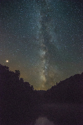
Milky Way over Mirror Lake
and Mars on the left
After hiking the area to scout locations in the drizzly rain, we hiked around and photographed the Mirror Lake area at night from about 10:00pm until 3:30am.  We should have been bone tired, but I was so excited I couldn't sleep when we eventually got done and headed back to the cabin.  I know I'm new at this and have a lot to learn, both in the night photography arena and in post-processing the photos.  This little adventure was not only a heck of a lot of fun, I learned an enormous amount from experimentation.  Looking back at it, and looking at the photos, there are many things I now know to do and am already planning a return visit.  I don't really have the patience of some of my photographer friends to take multiple shots that I can stitch and stack to remove noise and enhance visibility, but I now know that there is a whole lot I can do with "one-shot" photos to look really spectacular.  
Mirror Lake Falls and Milky Way

All in all, this was one of the more fun hiking adventures I've had.  We didn't take Boomer, because keeping track of a solid black German Shepherd at night would have just consumed too much of our time.  I did get to spend all day and all night out in a spectacular area with the love of my life, learning and marveling at the beautiful vistas we had all to ourselves.  Well, after dark we had the whole place to ourselves, anyway.  I'll be going back, and I now have a lot more tools in my bag of tricks to try.  On future hikes, I plan on using PhotoPills to scout for suitable night photography shots.  I'll save those plans for my use, and if my readers find value in them, I'll share them on the blog posts.  Looking forward to the next one!