GPS Coordinates: (Latitude, Longitude, Elevation)
Park - Dockery Gap Falls: 35.707369,-94.024927, 1104 ft.
Dockery Gap #1: 35.718195,-94.018577
Dockery Gap #2: 35.718028,-94.018238, 1158 ft.
Dockery Gap #3: 35.719274,-94.017609
Dockery Gap #4: 35.717797, -94.017702, 1314 ft.
Dockery Gap Falls: 35.720300,-94.01710, 1416 ft.
Dockery Gap #5: 35.720646,-94.017166
Dockery Gap #6: 35.720675,-94.017040
Dockery Gap #7: 35.720861,-94.017871
Dockery Gap #8: 35.720861,-94.017871
Dockery Gap #9: 35.721108,-94.018102
Dockery Gap #11: 35.722929,-94.017032, 1596 ft.
Upper Dockery Gap Falls: 35.722310,-94.017075, 1545 ft.
Dockery Gap #12: 35.721283,-94.016870
Park - Rattlesnake Falls #1: 35.693979,-94.029380
Park - Rattlesnake Falls #2 (today): 35.695468,-94.030871
Park - Rattlesnake Falls #3: 35.700089,-94.030424
Rattlesnake Falls: 35.693700,-94.028500
Pet-Friendly: Dogs will probably be fine if they are off-leash. This is some pretty rough and rugged terrain, with the usual assortment of Ozark jungle obstacles. Boomer is a big, magnificent, mountain dog, and I left him home today because I just didn't know what situations we would get into. As it turns out, I didn't have to make any bluff climbs or anything that he couldn't handle, but you just don't know in terrain this rough. I'll probably bring him along next time.
Hiking Statistics: The out-and-back hike today was a total of 5.12 miles. The minimum-to-maximum elevation difference was 534 feet, but there are many climbs up and down between benches, into and out of waterfall grottos, and general ups-and-downs while hiking. My round trip time today was 6:16 (hh:mm), but there was a lot of stopping for photos. This is a bushwhack all the way, with downed trees, rock jumbles, brier patches, undergrowth, and overall very rough, rugged, and steep terrain. This is a difficult bushwhack and not one for a beginner to take on. In the summer months, of course, it will be more difficult.
GPS files (.gpx format) - See maps at the bottom of this blog post
Devil's Eyebrow SIA (Dockery Gap area) waypoints
Dockery Gap Waterfalls GPS track
Road track - I-40 exit 24 to parking locations
Devil's Eyebrow SIA (Dockery Gap area) waypoints
Dockery Gap Waterfalls GPS track
Road track - I-40 exit 24 to parking locations
Jack White Falls and Phipps Branch Falls
What a great day to be out in the Devil's Eyebrow Special Interest Area (SIA). The what? No, not the Devil's Eyebrow Natural Area up near Beaver Lake. This is one I never heard of until I came back from today's hike to Dockery Gap Falls. Danny Hale sent me a map of the area was labeled 'Devil's Eyebrow SIA' for the entire area I was in today, so I did a little research to see what the deal was. I found bupkis, except for one post where an OHT member set up a group hike here, warning potential hikers that it was rated an "extremely difficult" bushwhack. Danny pointed me to a January 2008 episode of Exploring Arkansas in which our old friend Chuck Dovish explores the Devil's Eyebrow SIA with a couple of NFS guys that explain what they had in mind when they made it a Special Interest Area. Chuck's show is a good one and has given us lots of leads for day trips in Arkansas. But when I set out this morning, I didn't know any of this interesting information. All I knew is that I wanted to hike out to Dockery Gap Falls, so I loaded up and headed west.
Getting to the parking location is not that difficult, but will depend on
the direction you are coming from. Tim Ernst gives directions from nearby Mountainburg, so if you are approaching from the northwest, that would work best for you. I'll give my directions from exit 24 on I-40, and I'll post a map below with this road route.
 |
| Dockery Gap Falls (39 feet) with Rick - just happy to be there |
 |
| Bear left off Hwy 215 onto Locke Road |
 |
| Turn right off Locke Road onto Old Locke Road |
 |
| Turn right off Old Locke Road onto Hurricane Creek Road |
- Leave I-40 at exit 24 (Mulberry) and go north on Highway 215 for 9.3 miles, to the small community of Fern.
- In Fern, bear left (actually go straight) onto Locke Road (aka CR-74).
- Go 4.3 miles on Locke Road, and turn right (north) on Old Locke Road (aka FR-1007). It goes to a dirt road, but a pretty good dirt road, then back to a paved road. It also changes its name in there somewhere to 'Old Fern Road', so if you see a sign like that, don't be alarmed.
- Go 5.4 miles on Old Locke Road and turn right (south) on Hurricane Creek Road (still FR-1007).
- Go 0.9 miles on Hurricane Creek Road and park on the left off the road at the sharp bend in Hurricane Creek Road. This is parking location #1 for Dockery Gap Falls.
To get to Rattlesnake Falls, you would continue on down Hurricane Creek Road for an additional 1.6 miles, crossing Hurricane Creek, and park where an old Jeep road intersects on the right. Rattlesnake Falls is such an easy hike and is so close, it's practically a requirement to stop there as well.
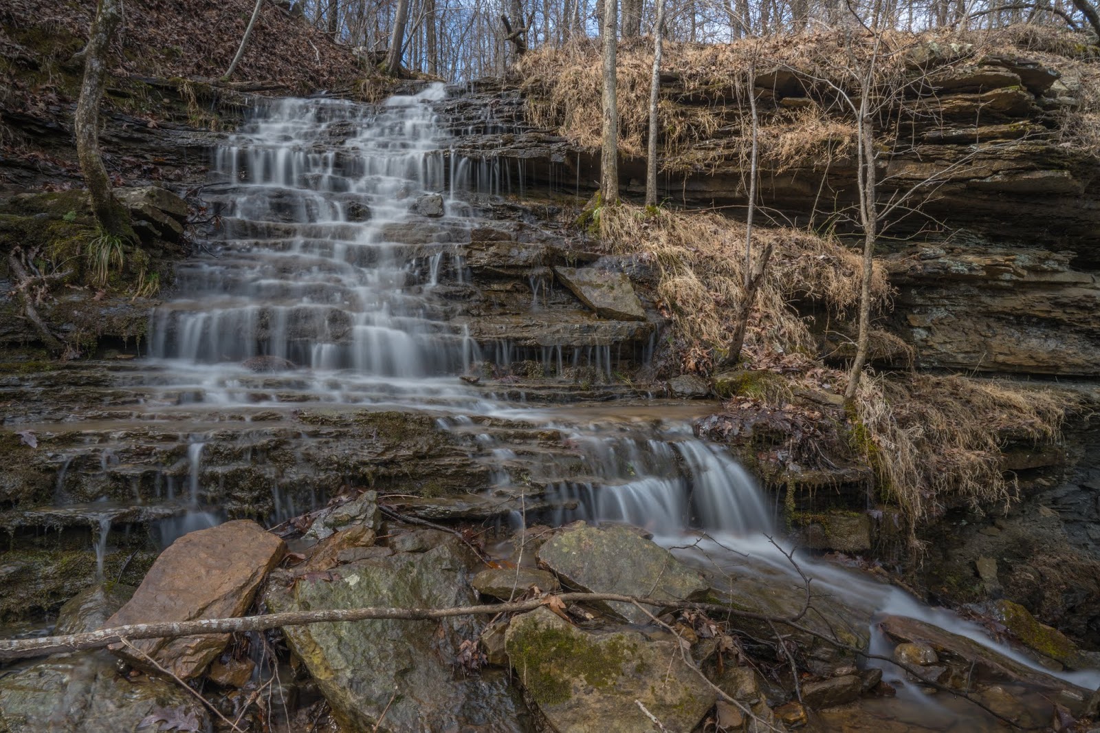
 |
| Falls #6 |
From the parking location, it is about 1.5 miles and a lot of rough terrain to Dockery Gap Falls. That being said, there will be some routes that are easier than others. I think most folks keep their bearings by going down the bluff on your left from the parking spot, crossing over the pipeline right of way, and turning left to follow the bluff around and into the hollow, then just following the creek upstream. I'm lazy and want to minimize the rock hopping along the creek, with the underbrush that seems to grow thicker there. I also wanted to make sure I checked out the great waterfalls above Dockery Gap Falls, but mainly it's the lazy thing. I'll detail the route I took today, then tell you what I think the optimal route is to just get to Dockery Gap Falls. One of the reasons I write this blog is to keep track of what I learn and optimize my route and my knowledge of the area. I learn something every time I go back to an area, and that makes it easier on me the next time. In other words, I'm so lazy, I'll wear myself out to find the easiest, most clear path from point A to point B.
 |
| Dockery Gap Falls Falls #5 visible above in the background |
While following the creek upstream is one way, I have learned to look for routes I think might be easier, so I'll study the topo maps and satellite imagery to try to figure that out beforehand. I hiked up the pipeline right-of-way because it is kept clear for the most part, up to the bench I wanted to be on to get above Dockery Gap Falls. When the pipeline right-of-way went almost vertical, too steep and overgrown to climb, I angled off into the woods on the right and kept climbing up to my target bench above 1400 feet elevation. From there, I headed north across the bench, going upstream in the hollow. There is an old road across this bench, and I followed it out to the edge of the bench, where it dived off down into the hollow below. Not wanting to lose the elevation I had, because I wanted to go to the upstream falls, I turned off the old road and stayed on the bench I was at, continuing to head upstream.
 |
| Falls #8 |
I think this worked out pretty well. There were, of course, the occasional patches of briers, blackberries, and other brambles, as well as downed trees, rock jumbles, and other Ozark mountain obstacles, but for the most part, you can hike the benches with a few ups-and-downs, mostly on the level. Dockery Gap is different than most hollows, in that there are few big side drainages. You get all the way up to within a quarter-mile of Dockery Gap Falls before crossing a drainage big enough to have nice waterfalls. When I hit this one, I went upstream for a distance, just to explore and see what else was there. It looked like it didn't have enough flow at that point to support any sizeable waterfalls, so I headed back downstream until I hit Falls #1, a small waterfall just a few yards upstream of Falls #2.
 |
| Falls #2 |
My original plan was to stay up on that upper bluff and explore the part of this hollow above this major bluffline, then descend below it and hit Dockery Gap Falls and this one on my way back. Unfortunately, I am distracted easily. It's relatively easy to climb down the bluff at this drainage to the right (south) of Falls #2. When I saw how it looked in the half-shade, half-full sunlight, I decided to climb down and shoot a few photos. Once down below the bluff, you can either climb back up, or there won't be another good bluffline break until all the way to Dockery Gap Falls, and well past it on the other side. After packing up the camera at Falls #2, I instinctively started hiking down the base of the bluff toward Dockery Gap Falls. There is another tall waterfall, Falls #3, where another small drainage flows over the big bluff. This is about halfway between Falls #2 and Dockery Gap Falls, and that's where I realized my plans had changed. That's what often happens, as I said I am easily distracted by all the natural beauty of my surroundings, but it's all good. If I'm going to climb back up above the bluffline and back down again, I might as well see the main attraction first.
 |
| Dockery Gap Falls |
When you come around the corner of the bluff from Falls #3, you can see the whole bluff stretched out in front of you with Dockery Gap Falls well down the bluff. It's quite a sight when the creek is flowing well, and not one you'll see if you hike up the creek on your way upstream. I should mention there is another waterfall in the drainage downstream of Falls #2, and you will see that one if you come up along the creek. I meant to double back to see it and forgot all about it when I headed back. Dockery Gap Falls was great today; it was full, bright, harsh sunlight when I arrived at it, which makes photography difficult for it, but it made the experience of being there all the better. It was fantastic. I spent a good deal of time here, taking it in and taking some photos. I found one spot high up under the overhang where one of the two waterfalls just upstream of Dockery Gap Falls could be seen.
 |
| Falls #5 (left) and Falls #6 (right) |
To get upstream of Dockery Gap Falls, you have to climb that huge bluffline. Back the way I came, the opportunity to do that was about a quarter mile back downstream, past Falls #2. On the right side (as you face upstream), the bluffline breaks just a hundred yards or so from Dockery Gap Falls. Following the base of the bluff up and around would be the easiest route, if it were not for some large trees that have fallen right over it. Instead of trying to pick my way through that mess, I just went downstream around it, and then up above the bluff. Coming around the bluff toward the top of Dockery Gap Falls, you can see a small waterfall right at the top that isn't visible until you get to the top. Just a few yards upstream of the top of Dockery Gap Falls, the stream splits into two forks, with a nice waterfall just above the fork on each side. Falls #5, on the left, is a more traditional looking box waterfall, while on the right side, Falls #6 is more of a cascade that flows under a little stone natural bridge at its base.
 |
| Falls #6 |
Going upstream, it was kind of a toss-up as to which fork to take. I figured going to Upper Dockery Gap Falls would be an up-and-back effort since it has tall, unbroken bluffs on both sides quite a way upstream until you come to it. I decided to take the left fork first, then get above that next big bluffline and do some exploring above. Going above Falls #5, Falls #7 is already visible. If you look off to the right, you can see a much taller bluff that this fork used to flow over, making a much larger waterfall. Today, there was a trickle of flow over the old route of the creek, but not much. At some point in the past, this stream had been re-routed and cut a new channel that almost all of the flow now goes down. This makes for a less spectacular waterfall, but there are now three that take its place. Falls #8 is a long, pretty cascade just above Falls #7, and Falls #9 is a two-drop waterfall coming over the bluffline above that. I circled around, up, and over the bluff there, continuing around to Upper Dockery Gap Falls.
 |
| Upper Dockery Gap Falls |
On both forks above Dockery Gap Falls, I only went far enough to see that there probably wouldn't be enough flow today for any waterfalls I might find higher in the drainage. They were flowing nicely at this elevation but seemed to lose flow quickly as I ventured further upstream. A short distance above Upper Dockery Gap Falls was a small cascading waterfall. As the creek entered the big drop down into the grotto for Upper Dockery Gap Falls, it drops through a continual series of short waterfalls before finally dropping down the steep cascade for the lower part of Upper Dockery Gap Falls. From the bottom of this waterfall, you can't get a good angle to see the entire run of the waterfall. I found just one spot halfway between benches where I could hang onto a tree and get a shot of the whole thing without falling to my death. If it were not wintertime, even that shot would be blocked by the foliage. I'm starting to see the value of drones.
 |
| Upper Dockery Gap Falls |
I thought I had found a way to pick my way down to the base of Upper Dockery Gap Falls, but there was still about a 12-foot bank that was slippery and just too iffy to try. I do have a satellite beacon, an Inreach Explorer, but I would rather not have to call in the SAR teams to an area like this. So I went back the way I came, on top of the bluff and all the way around the left fork, then all the way up the canyon into the right fork and Upper Dockery Gap Falls. I did not name this one, by the way. I got the coordinates and name from an old waterfall database but have not seen any other photos of it or references for it. It's a beautiful waterfall, and it's a shame more folks don't venture up to see it. Leaving Upper Dockery Gap Falls, I hiked down the east side of the canyon and stopped by Falls #12 on my way out.
 |
| Falls #12 |
By the time I got back down the bluffline break to Dockery Gap Falls, the sun was starting to set and I stopped to take a few more photos without so much glare. Heading back, I decided it was probably best to forego any further exploring. I still wanted to visit Rattlesnake Falls, which is less than two miles down the road. On top of that, this is a difficult enough place to hike in the daytime. I carry a headlamp in my pack, but this is not the kind of place I want to be stumbling around in the dark. I stopped at Falls #2 long enough to take some photos of it in the shade, then I kept hiking down the bench on that level. I was pretty sure there should have been an old bench road along this bench since it stays relatively flat (emphasis on relatively) for a long way down the hollow.
 |
| Falls #5 |
I eventually found the faint traces of an old roadbed and followed it all the way back down to where that old road across the bench above this one descended down into the valley. It was a very faint trace road that I lost on occasion but always found it again, mostly on the outer edge of the bench. I like the old roads the pioneers blazed back in the day, not so much because they have less undergrowth. Sometimes they do, but it has been so long since this was used that the foliage was not that much different than the rest of the area on the bench. What is nice about these old road beds is that they had at one time had rocks cleared off them and they generally took the route with the least slope differences. There's only so much that horses and mules will put up with. Don't get me wrong, there are still downed trees and such, what I call 'Ozark obstacle courses', but I still made much better time following the old trace of a bench road than I otherwise would have.
 |
| Falls #2 |
The old bench road ran down to the old logging road that crossed the bench above, the one I had followed briefly on the hike into the area. I suspect the old bench road ran down the bluff toward the mouth of the hollow where it flows into Hurricane Creek, but I went the way I knew and followed the old road up to the next higher bench and over to the pipeline right-of-way. Then it was just a matter of hiking down the pipeline clearing and over to where I had parked this morning. The short hike between the parking spot and the pipeline right-of-way is probably the worst of the bushwhacking conditions, in my opinion. Still, it isn't too hard to skirt around briers and brush and make your way to the road. My GPS logged only 5.12 miles for the entire round trip hike. That doesn't sound like a whole lot, but these were some pretty rough and rugged miles. I was getting a little tired by the time I got back to the FJ, but I was still intent on seeing Rattlesnake Falls before I headed home. That will be the next post!
 |
| Dockery Gap Waterfalls GPS track |
 |
| Best Routes (in Rick's opinion) Blue - to/from Dockery Gap Falls from pipeline right-of-way Orange - Dockery Gap Falls to/from upstream waterfalls |
 |
| Road track - I-40 exit 24 to Dockery Gap and Rattlesnake Falls parking |
No comments:
Post a Comment