Thursday, June 4, 2015

Petebear Falls, Spoke Plant Schoolhouse, Arkansas Ozarks

6/3/2015 - Petebear Falls and Spoke Plant Schoolhouse

GPS Coordinates:  (Latitude,  Longitude)
  Parking location - Petebear Falls:  35.75027  -93.60290,  
  Petebear Falls: 35.74986  -93.60301
  Schoolhouse in Little Mulberry Creek near Spoke Plant:  35.76852  -93.58894

Pet Friendly: Yes, dogs on or off leash should be fine.

Motorcycle Friendly: No, not really.  The dirt roads are in relatively good shape, but are still dirt roads.  While you could take a heavy bike on this road, you wouldn't like it, and neither would your bike.

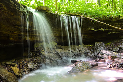
Petebear Falls
Photo by Dan Frew
This was the last stop of a full day of hiking today.  My hiking companions today, Dan Frew and Jim Fitsimones, and I had already been to Bootlegger Falls and Sixty Foot Falls.  Compared to those bushwhacks, this was basically just sightseeing.  I hesitate to even call this one a hike, since for both of these points of interest you simply park on the side of the road.  For Petebear Falls, you park and climb down to the grotto immediately below the road.  For Spoke Plant Schoolhouse, you park and find a way across the creek.  All I had seen on Petebear Falls was a photo Brian Emfinger had posted on Panoramio, and all I knew of Spoke Plant was the history Dan had researched.  

To get there, take Highway 103 north approximately 20 miles from Clarksville and bear right at the intersection with Highway 215.  Go 0.8 miles east on Highway 215 and turn left on CR-5211.  Go 7.9 miles on this road.  The road name changes to CR-100, CR-1005, and CR-35, but just stay on the main road.  Bear left on CR-6151 and go another 1.4 miles, and park on the left (north) side of the road.  The road bends sharply right about a half mile from the parking location, so make sure you stay with it.  

Petebear Falls is below the road on the left (north) side in the sharp left turn just before the parking location.  At the GPS coordinates for the parking location, there is a culvert passing under the road.  There is an access down to the base of the waterfall here.  It is not that difficult a scramble, but apparently someone thinks this is a trash heap and have dumped some litter off the bluff downstream of the waterfall.  It is very disappointing, to say the least, to find this kind of thing in such a beautiful place.  Fortunately, the vast majority of Ozark waterfalls are far from the nearest road.  The kind of folks that trash up a place like this are not likely to hike out to a remote location.  Okay, I'll turn my rant mode off now.

Spoke Plant Schoolhouse
Our next spot was a little piece of Arkansas History.  At one time, when folks used wagons to get around, there was a need for wagon wheels.  Those wheels needed spokes, and the spokes were made right in this valley.  As those dang automobiles bred like rabbits and proliferated, the need for wagons declined, and so did the need for wagon wheel spokes.  The community dissolved as the jobs went away, and today it has all but vanished.  There is still a one room schoolhouse standing across the road from where the old Spoke Plant post office and general store used to be.  It is actually on an island in the Little Mulberry Creek, which runs along the road here.  

Inside the Spoke Plant Schoolhouse
To get there, continue driving north on CR-6151 for another 1.8 miles.  At 1.4 miles, where the road crosses from Johnson County into Madison County, the road name changes to CR-4845 (old CR-150).  The old schoolhouse will be on the left, back in the trees across the creek from the road.  Where I marked the GPS coordinates, there is a large downed tree trunk that you can walk on across the creek.  Not a lot of hiking involved, but I find the hidden history of these places fascinating. 

Bootlegger Falls, near Kilgore Gap, Arkansas Ozarks

6/3/2015 - Bootlegger Falls

GPS Coordinates:  (Latitude,  Longitude,  Elevation)
  Parking location: 35.76721  -93.68408,  2170 ft.
  Unnamed Falls #1: 35.76780  -93.69075, 1918 ft.
  Bootlegger Falls: 35.76748  -93.69159,  1810 ft.

Pet Friendly: Yes, dogs off leash should be fine. This is a pretty thick area, vegetation wise.  If your dog is not good in complete bushwhack situations, you might want to consider leaving it at home.

Motorcycle Friendly: No.  You have to take a number of poorly maintained dirt roads, some with fresh layers of loose gravel.  

GPS files (.gpx format) - maps of GPS tracks are at the bottom of this post:
  GPS track for hike to Bootlegger Falls, utilizing old trace road
  GPS track for return hike up the mountain to CR-502


Bootlegger Falls
Photo by Dan Frew
The wet season was showing signs of being over.  While some parts of the state were still under flood warnings from releases upstream in neighboring states, the creeks were already starting to recede.  It was time to get out and see some of the other waterfalls that rarely get visited.  Bootlegger Falls is one of those.  This waterfall is not in 'the book', Tim Ernst's great guidebook, Arkansas Waterfalls.  All I had to go on was a photo posted on Panoramio by John Moore, and the GPS coordinates embedded in it.  

My friends Jim Fitsimones and Dan Frew were my hiking companions today.  Jim is one of those 'get an early start' guys, and wanted to start today at 5:00 am.  That's not my usual daily routine, but I dragged myself out of bed, made a big breakfast, Dan came by to collect me, and we met Jim in Clarksville right on time.  We started in Clarksville, and went up Highway 103 to Highway 215, but I'll give more generic directions from the nearest freeway here.

To get there;

  • Turn north off I-40 at exit 37 onto north Highway 219.  
  • Go 8.5 miles and bear left onto Pink Twist Road (CR-88).  
  • Go 5.0 miles on Pink Twist Road and turn left (west) onto Low Bridge Road (FR-1504).  
  • Go 4.0 miles on Low Bridge Road, then turn right onto Highway 215.  
  • Just 0.4 miles on Highway 215, turn left on FM-1003L.  
  • Go 2.7 miles, and turn left (north) onto FR-1533.  
  • Go 4.1 miles north on FR-1533, then turn right on CR-502.  
  • Go 2.9 miles on CR-502 and park on the left, opposite an old trace road with a forest service gate across it.
There were a couple of ways we could approach this bushwhack.  We could take a shorter, but steeper and more difficult bushwhack directly from the CR-502 road.  OR, we could utilize the old road that went part way down into the hollow for a little easier, but longer, hike.  It is about a 300 foot elevation change from the road to Bootlegger Falls.  We chose the hike on the old road, as the undergrowth was very thick along the road.  We started descending into the hollow, passing a food plot toward the end of the old road.  When we got to a point on roughly the same elevation as Bootlegger Falls, we cut across toward it.  The first drainage we passed up, as it appeared to go off in a direction away from my Bootlegger Falls GPS coordinates.  
Unnamed Falls #1

The second side drainage we came to appeared to run in the right direction, so we hiked up it and sure enough, we soon came to a nice little waterfall.  Unfortunately, it was not the waterfall we were looking for.  This one was nice, but did not match the photo of Bootlegger Falls.  Unnamed Falls #1 looked to be a wet weather waterfall, and we still had enough groundwater to get it flowing.  This would prove to be a costly one for me.  After setting my camera and tripod up, I left it to get some small branches out of the field of view.  As soon as I did, the tripod foot sank into the soft earth a little and fell over backward.  It fell at just the right spot to catch a very sharp rock on the LED display, breaking it.  Great.  The first photo-op of the day and my very expensive V3 was broken. Argh.  All I had left for taking photos and videos was my phone, so when you see "photo by Dan" or "photo by Jim", it's because I had to rely on them for any decent photos today.

We hiked around the bluffline to the right (west), and straight downhill about another 100 feet, and soon came to the top of Bootlegger Falls.  Hiking around on the right side, there is access down to the base of the waterfall.  Bootlegger Falls was no doubt named for the old stone ruins near the base of the waterfall, tucked up partially beneath the overhanging ledge above.  It looks like the remains of a small stacked stone hut, and next to it is a stone fire ring.  The fact that the fire ring is outside tells me it probably was used for a still, and not for heat.  If you wanted a place to make whiskey out of sight of government busybodies, this was certainly a good location.

Leaving Bootlegger Falls, we actually ended up cutting across the hollow and ascending on our way toward that old trace road.  By the time we approached it, we actually came up on CR-502 and followed it a short way down to where we parked.  Having gone downhill one route and uphill the other way, my inclination would be to take the path of least resistance and follow the old trace road while you can.  If hiking this canyon in the winter, maybe the undergrowth would not be such a big factor.  Hiking by either route we took is roughly a mile each way.

This is one of those not-so-easy-to-get-to waterfalls.  The old stone ruins are kind of cool, but Bootlegger Falls itself is not all that impressive compared to lots of others in the Ozarks.  I'm sure this hollow has many more waterfalls and other features hidden in it, but a more complete exploration will have to wait for cooler weather when the undergrowth won't be an issue.  Dan, Jim, and I were off to our next adventure of the day, Sixty Foot Falls.
GPS Tracks - Bootlegger Falls
Red - utilizing old road
Blue - complete bushwhack

Sixty Foot Falls, Arkansas Ozarks

6/3/2015 - Sixty Foot Falls and upstream water features

GPS Coordinates:  (Latitude,  Longitude,  Elevation)
  Parking location #1: (at Y in jeep road):  35.72793  -93.77981, 1700 ft.
  Parking location #2:  35.72239  -93.77838, 1420 ft.
  Parking location #3:  35.71917  -93.77851, 1181 ft.
  Sixty Foot Falls: 35.72154  -93.78679, 980 ft.
  Upper Sixty Foot Falls: 35.72170  -93.78619, 1083 ft.
  Unnamed Falls #1: (Double cascade): 35.72242  -93.78525,  1154 ft.
  Unnamed Falls #2:  35.72266  -93.78505,  1195 ft.
  Unnamed Falls #3:  35.72258  -93.78484,  1211 ft.
  
Pet Friendly: Yes, dogs off leash should be fine.  There were a couple of places where we had to climb on rocks to get where we wanted to be, particularly going to Upper Sixty Foot Falls from Sixty Foot Falls.  Some dogs may have to find another way above the last part of the bluffline.

Motorcycle Friendly: No.  No, no, no, no, no.  A dirt bike, sure.  Any other kind of motorcycle should not be anywhere close to these roads.

GPS files (.gpx format) - maps of GPS tracks are at the bottom of this post:
  GPS Track - Parking location #1 to Sixty Foot Falls
  GPS Track - Sixty Foot Falls to all upstream waterfalls, back to parking location #3


Sixty Foot Falls
Photo by Dan Frew
My hiking companions today, Dan Frew and Jim Fitsimones, and I had already finished a bushwhack to Bootlegger Falls, and were off to the next new waterfall (for me, anyway), Sixty Foot Falls.  This waterfall is in Tim Ernst's guidebook, Arkansas Waterfalls, but his description of the hike did not seem all that appealing on a muggy day when the undergrowth was particularly burdensome.  The hike Tim describes seems more like something you would do in the dead of Winter, when the bushwhack is easier and the temperature at least low enough that you won't sweat to death.


The traditional way to get to Sixty Foot Falls is to  take I-40 exit 35 to north Highway 23 (Pig Trail), then park next to Highway 23 about 2.6 miles north of the small community of Cass.  Then it is a 1.5 mile bushwhack down to Sixty Foot Falls, including crossing a good sized creek.  The real problem is the 1.5 mile climb back out to Highway 23, which is not only a bushwhack but an elevation difference of 700 feet.  We decided to see if we couldn't go a bit closer to the waterfall, and on the same side of Mountain Creek.  


Sixty Foot Falls
Photo by Dan Frew
Here's the route we took;  Go 19.8 miles on Highway 23 and turn right on CR-81 (Fly Gap Road).  Go 2.8 miles on CR-81 and turn right on FR-1003P.  Be warned; this forest service road is a little rough.  If you don't have a 4WD vehicle, you can probably make it OK, but no guarantees.  Look at the road conditions and use your good judgement. Go 1.0 mile on FR-1003P and park at the 'Y' in the road.  This is parking location #1 for Sixty Foot Falls.  Unfortunately, this is still over 700 feet elevation above our goal, and below this point, you really need a serious 4WD vehicle.  Fortunately, Dan has one and isn't afraid to use it.  We left Jim's 4WD Tacoma here, and all three of us went further down the mountain in Dan's Jeep.  At parking location #2, we thought large rocks in the road would prevent going further, but after scoping it out, Dan felt he could get past them.  We proceeded down to parking spot #3, which has a small area to pull out and park.  There was also a large tree wedged across the trail at grill height, so we weren't going any further anyway.

As it turned out, we parked at an ideal location for today's hike.  It was about as close as we could get to the waterfalls without a helicopter or dirt bike, and was very close to the elevation of the highest waterfall in the drainage.  We hiked down the old 4WD trail, which by our maps should cross directly below Sixty Foot Falls.  Somehow, we missed the split in this trail and found ourselves at the crossing for Mountain Creek, which we knew was not right.  So we backtracked a little and found the branch of the 4WD trail going along the north side of Left Prong Mountain Creek.  Our hike to Sixty Foot Falls along this route was almost two miles, but was fairly easy hiking along the old road.


Sixty Foot Falls - from behind waterfall
Photo by Dan Frew
Sixty Foot Falls could easily be heard from the trail, and as soon as you turn up its stream you can see the waterfall itself.  It is actually only 56 feet tall, but I imagine the folks that named it did about the best estimating they could.  Today, I was impressed with the power of this waterfall.  It seemed to have a great deal of flow, especially considering the fact that this drainage seemed to only cover a small area.  We learned the secret to where this water was coming from when we climbed to the top of the drainage.


Upper Sixty Foot Falls
Photo by Dan Frew
From Sixty Foot Falls, you can hike up the right side (east) to climb above it's bluffline.  Above it, there are a number of small cascades, and less than 100 yards from Sixty Foot Falls, you will find Upper Sixty Foot Falls.  While Sixty Foot Falls is more of a traditional Ozark waterfall, the Upper Sixty Foot Falls is a beautiful, tumbling, stair-step type waterfall reminiscent of Lichen Falls.  The source of the water is quite cold, and if you stand in front of it when there is even the hint of a breeze, it feels like you are standing in front of an air conditioner.


Double Cascades
This is a steep mountainside and we knew there was a lot more of it above us than below.  Still a little curious as to where all the water flow was coming from, we decided to go above Upper Sixty Foot Falls and explore a little more.  About 150 yards upstream, we came to a beautiful double cascade, where the creek had split into two sections, and cascading down both sides of this 'island' before flowing back together into a single creek.  


Unnamed Falls #2
Photo by Dan Frew
Immediately above the double cascade was yet another waterfall, Unnamed Falls #2.  This waterfall is a short, three-stepped waterfall that forms the perfect cap to the longer extended cascade.  Going upstream just a few more yards, we found Unnamed Falls #3, another stair-step type waterfall with a longer cascade below it.  The water flow here was still quite strong, and we could see a shallow grotto directly above Unnamed Falls #3 with about a 20 foot rock cliff around it, but the waterfall you would expect to come over that rock bluffline was not there.  The creek just seemed to vanish.


Unnamed Falls #3
Photo by Dan Frew
Climbing to the top of Unnamed Falls #3, it was finally clear why the flow in this small drainage was so high, and why there was no creek above it.  There is a spring right at the top of Unnamed Falls #3 that the water just comes surging out of.  Along the bluffline to the right a few yards you can see into a large crack in the rock; inside, there is some kind of cave system with the water flowing through it and out the spring.  


Spring feeding Unnamed Falls #3
Photo by Dan Frew
With the water being forced up and vertically out this hole at the top ofUnnamed Falls #3, I suppose that makes it more of an artesian well than a spring.  I know little about the technicalities of the geological and hydrological forces at work here, I just know a cool water feature when I see it.  I climbed above the spring/artesian well and found the creek bed where runoff water flowed over the bluff into the lower creek.  Above the bluff surrounding the spring, this creek was dry.  I hiked upstream about a hundred yards and found no trace of water above the spring. 

Spring feeding directly into Unnamed Falls #3
I suspect this chain of waterfalls will be like most of the cave waterfalls and have pretty good flow even in the drier seasons.  Since the spring was about the same elevation as our parking location for the jeep, we decided to keep to the high ground and bushwhack back toward the old 4WD road.  In this area, the undergrowth was not all that bad, and in about a half mile we were back where we had parked the Jeep.  The total distance from Sixty Foot Falls, up the creek canyon to the spring, and back to the parking location was only 0.8 miles.

We loaded up and made our way back up the 4WD road.  It was sure a lot easier letting Dan's Jeep take us back up to parking location #1 than making that 500+ foot elevation change ourselves.  My Explorer has 4WD and decent ground clearance, but it would have been horrible (and probably disastrous) to try to take it on this road.  I have to get me a Jeep.

I would highly recommend this hike, even if you have to park much higher up the mountain and make that big climb back out.  Just hydrate and take your time.  That 4WD road does continue on and back up the other side of Sixty Foot Falls, eventually coming out on Highway 23.  Maybe I'll give that a try when Santa brings me that Jeep.  There are also two other waterfalls nearby, Mountain Creek Falls and Spirit Mountain Falls.  We bypassed those this trip, but I plan to be back.
GPS Tracks - Sixty Foot Falls
Red - from parking location #1 to Sixty Foot Falls along 4WD road
Blue - Sixty Foot Falls to all upstream waterfalls, bushwhack to parking location #3
GPS Tracks - Sixty Foot Falls
Zoomed out view of valley


Tuesday, June 2, 2015

Lichen Falls and Lynn Hollow Falls, Ozark Highlands trail near Oark, Arkansas Ozarks

6/1/2015 - Lichen Falls and Lynn Hollow Falls

GPS Coordinates:  (Latitude,  Longitude,  Elevation)
  Parking location: 35.75852, -93.52789, 2074 ft.
  Lichen Falls: 35.75675, -93.53131, 2000 ft.
  Unnamed Falls #1: 35.75524, -93.53195, 1985 ft.
  Lynn Hollow Falls: 35.75220, -93.53490, 1815 ft.
  
Pet Friendly: Yes, dogs off leash should be fine. You may encounter other hikers since this is mostly on the Ozark Highlands Trail.  If your dog is incompatible with other folks, leave it at home.

Motorcycle Friendly: No, not really.  The dirt roads are in relatively good shape, but are still dirt roads.  While you could take a heavy bike on this road, you wouldn't like it, and neither would your bike.

GPS files (.gpx format) - maps of GPS tracks are at the bottom of this post:
   GPS Waypoints for Lynn Hollow (contains the coordinates for the waypoints listed above), Eldridge Hollow, Accord Hollow, and Estep Creek
   GPS Track - Parking to Lichen Falls to Lynn Hollow Falls

Lynn Hollow Falls
Since we were 'in the area anyway' (excuse #1), Boomer and I decided to check out Lichen Falls and Lynn Hollow after we finished hiking through Eldridge Hollow.  They really are close together.  In fact, if you have the extra time on your hands, you could park at Eldridge Hollow and do that hike, then just hike the other way on the Ozark Highlands Trail (OHT) to Lynn Hollow.  It's about an extra 1.5 miles each way, though, and today we didn't have that much time.  So we loaded up, drove back to CR-5261, then up to the Lichen Falls parking area.

Turn off Highway 215 after Oark here
Getting there is easy; driving directions don't get much simpler than this.  From Clarksville, take Highway 103 north for 20 miles, bear right at the intersection with Highway 215, and keep going into the small community of Oark.  Keep going through Oark and 0.1 mile out of town, turn left on CR-5261 (old CR-34, aka Arbaugh Road/FR-1404).  Go 6.8 miles on CR-5261 and park on the right.  There is a nice parking location with forest service trailhead signs right where the Ozark Highlands Trail (OHT) crosses the road.  And of course, the Oark General Store is always a great place to stop and eat.

Parking Area
We crossed the road and headed west on the OHT.  When you hike this part of the trail, look down at your feet.  Practically the whole trail is covered with a fine moss.  There are not many places you can hike that have cushy carpeted hiking trails.  Soon, you will see a small creek on the right side of the trail.  This is the creek feeding Lichen Falls.  I had been hoping to catch Lichen Falls really running well, and with all the recent rainfall I fully expected it to be that way today.  If you search for photos of it online, there are many showing it just beautiful and full, with the water really roaring down the waterfall.  None of those photos are mine.  But today, the creek did not appear swollen at all, so this particular spot must not have received the amount of rain the rest of the surrounding area did.

Lichen Falls
Less than a quarter mile from the parking area, Lichen Falls will be on the right side of the trail.  You can get a very good view of it from the OHT, and it might be advisable to leave it at that.  There is an access to the upper section of the waterfall, but it is very steep and slick.  From the upper section, there is a ledge running along the bottom of the bluff below the OHT down to the base of the lower section.  The problem is, this waterfall needs a good amount of rain to really get going and look great.  When it rains, water will be running off the bluff directly above that ledge, and you can't walk down it without getting soaked.  Not to mention it gets considerably more slippery and dangerous when wet.

I went all the way down to the base of the lower section of the waterfall, but Boomer has better instincts about that kind of thing.  He refused to walk on the ledge, and just stayed at the upper section.  Hmm.  It doesn't speak well of you when your dog has more sense than you do.  I was a little disappointed at the flow today on Lichen Falls, but it's still a very pretty waterfall.  Well worth the short hike.

Lynn Hollow Falls
From Lichen Falls, we hiked west on the OHT.  We soon came to a small drainage with a waterfall just below the trail.  This one also appeared to be suffering from not enough flow.  With flooding in other parts of the state, that just seemed a little weird.  Continuing on down the OHT, the trail makes a sharp turn to the right, then approaches the main creek running through Lynn Hollow.  The OHT turns left and crosses the creek, but if you go straight and stay on the right side of the creek, the trail follows the creek down to Lynn Hollow Falls.  It is actually a series of small waterfalls, with the largest flowing into a large emerald pool. 

Boomer had a great time swimming and cooling off in the pool and made several thwarted attempts at knocking my tripod over or shaking water off on my camera.  He's a very well behaved dog, but he knows the camera gets my attention and he is not Okay with that.  But I'm on to him now, and know just what to look out for.  On previous hikes, he did some major damage that I chalked up to him just being active and boisterous.  I know better now.   

After leaving Lynn Hollow Falls, we headed back to the parking area.  Boomer was trying to get to the Explorer for some rest time, and almost crossed the road without looking.  I made him sit and get a little retraining lecture, even though I'm pretty sure there wouldn't be another vehicle on this road all day. 

The total distance from Lynn Hollow Falls to the parking area is less than a mile.  The total elevation change is about 250 feet, but it is spaced out over a good distance and the OHT is easy hiking.  All in all, I would rate this an easy hike. Better if Lichen Falls is running full blast, of course, but a great area just to get out and enjoy nature anytime.
GPS Track - Lynn Hollow
Note that the red dashed line is the mapped location for the OHT.
The red solid line is the actual location of the OHT.

Eldridge Hollow Waterfalls, Ozark Highlands Trail, Arkansas Ozarks (near Oark)

6/1/2015 - Eldridge Hollow - Tucked Away Falls, Eldridge Hollow Falls, Split Falls, Tall Falls, Beck's Falls, and many more waterfalls

GPS Coordinates:  (Latitude,  Longitude,  Elevation)
  Parking location: 35.75660, -93.55363, 2022 ft.
  Leave OHT for Tucked Away Falls: 35.75359, -93.55073, 1885 ft.
  Unnamed Falls #1: 35.75293, -93.55151, 1836 ft.
  Tucked Away Falls: 35.75264, -93.55148, 1803 ft.
  Tucked Away Falls - Access point: 35.75199, -93.55114, 1804 ft.
  Eldridge Hollow Falls:  35.75190, -93.54990, 1845 ft.
  Eldridge Hollow Fern Falls: 35.74988, -93.55056, 1829 ft.
  Unnamed Falls #3: 35.74392, -93.55548, 1843 ft.
  Split Falls: 35.74855, -93.55042, 1817 ft.
  Unnamed Falls #7: 35.74920, -93.55125, 1769 ft.
  Turn off OHT for Tall Falls:  35.75359, -93.55074, 1887 ft.  
  Unnamed Falls #4: 35.74165, -93.55525. 1780 ft.
  Unnamed Falls #5: 35.74165, -93.55525. 1780 ft.
  Beck's Falls: 35.74165, -93.55525. 1780 ft.
  Tall Falls: 35.74221, -93.55628, 1732 ft.
  Tall Falls - Access point: 35.74242, -93.55620, 1732 ft.
  
Pet Friendly: Yes, dogs off leash should be fine. You may encounter other hikers since this is mostly on the Ozark Highlands Trail.  If your dog is incompatible with other folks, leave it at home.

Motorcycle Friendly: No, not really.  The dirt roads are in relatively good shape, but are still dirt roads.  While you could take a heavy bike on this road, you wouldn't like it, and neither would your bike.

GPS files (.gpx format) - maps of GPS tracks are at the bottom of this post:
Eldridge Hollow Falls (upper tier)
Since the streams and rivers still seem to be flowing well from the recent rains, I decided to head out to another area that I had never documented before.  Eldridge Hollow was another of those valleys that seemed to be a good area for waterfalls, but other than some photos on Panoramio, I couldn't find anything in my research for the area.  Eldridge Hollow has the advantage of having the Ozark Highlands Trail (OHT) running right through it, making for very easy hiking.  On the OHT, Eldridge Hollow is between Lynn Hollow and Accord Hollow.  Both Lichen Falls (in Lynn Hollow) and Accord Hollow Falls are in Tim Ernst's excellent guidebook, Arkansas Waterfalls, but Eldridge Hollow is not.  So Boomer (our German Shepherd) and I loaded up and set out to do a little exploring.

Turn north off Highway 215 here
Getting there is pretty easy, it's just a little off the beaten path.  From Clarksville, take Highway 103 north, bear right at the intersection with Highway 215, and keep going into the small community of Oark.  If it's eating time, stop at the Oark General Store for a meal.  You won't find better food anywhere, especially burgers.  Keep going through Oark and 0.1 miles out of town, turn left on CR-5261 (old CR-34).  Go 4.5 miles and bear left onto CR-6220.  Go 1.7 miles and turn left into an old Jeep road.  Park in the clearing about 100 yards down this old road.  Pay attention to the road signs.  About a mile before the turn onto CR-6220, CR-6200 branches to the left; don't be confused and keep bearing right here to stay on CR-5261.  There is also a 'Y' about a quarter mile before the parking location; keep bearing left on the main road.

Parking Location
You can always park just off CR-6220 and hike the extra few yards if you have a passenger car, but I think most vehicles should be able to make it to the clearing.  I will confess to putting the explorer in 4WD before crossing a big mud hole where you enter the clearing.  I couldn't tell how deep it was; as it turns out, 2WD would have been fine, but you just never know if you can't see the bottom.  You probably missed it, but the old road crosses the OHT before getting to the parking location.  The OHT goes back into the clearing and continues out of it at the back left side (southeast corner).

Small waterfalls downstream of Tucked Away Falls
Boomer and I got moving and started our hike down the OHT.  Unfortunately, about a quarter mile later, I felt as if something were just not right.  Double checking everything, I had my phone, my GPS, water, camera...  D'oh!  Had the camera, but not the tripod.  The thought of spending all day trying to balance my phone on rocks and using the timer outweighed my laziness, so we headed back.  Sure enough, there was the tripod on the hood of the Explorer where I had left it.  All for the best, probably.  It's not like I couldn't use an extra half mile of hiking.

Unnamed Falls #5
Getting back on the OHT, we headed for the first waterfall I wanted to check out.  The Ozark Highlands Trail crisscrosses the slope at the head of Eldridge Hollow, going down about 100 feet in the first half-mile.  After that, it stays at about the same elevation through the valley, making for easy hiking.  The OHT has some ups and downs as it crosses minor drainages, but for the most part, the hiking is on the level.  Most of the waterfalls in Eldridge Hollow are right on the OHT, but this first one was not.  I have marked a location about a half mile from the parking location to turn off the OHT and go down to the main creek in the hollow.

Unnamed Falls #1 - with Boomer
Dropping off the OHT to the creek below, you come to a series of waterfalls in less than 100 yards.  I had marked a location for Tucked Away Falls and was headed for that.  On the way to it, we came across Unnamed Falls #1, a nice little waterfall with about a six-foot drop, and a bunch of cascades downstream.  From there, we continued downstream and soon came to the top of Tucked Away Falls.

Tucked Away Falls - from top
This was one of the few waterfalls in this hollow that I could even find a photo of.  John Moore (is there a square foot of Arkansas this guy has NOT photographed?) had posted a photo of this waterfall taken from the right bluff, where you could just see that a waterfall was there.  He had captioned the photo "Tucked away in Eldridge Hollow".  After going through some hiking gymnastics to get down to the base of the waterfall, I thought that would be perfectly fitting as a name; Tucked Away Falls.  

Tucked Away Falls
The bluffline below Tucked Away Falls on the right (facing downstream) did not appear to have any breaks for quite a way.  On the left side, I did find a bluffline break (GPS coordinates listed above) that was a steep, but doable, access down.  This access point is about a hundred yards downstream, and once you descend below the bluffline you still have to make your way back upstream. There is a lot of brush, downed trees, and a steep and rugged slope.  It's a struggle to get to the base of the waterfall, but we made it without sliding on our butts into the creek.  Tucked Away Falls itself is beautiful, worth the extra effort to get to it.  It has stair-steps at the top half, then falls off the angle of the 'stairs' on the way down.  This is one of the rare waterfalls that I like the shot from the top of the waterfall as much as from the base.

Unnamed Falls #2
From Tucked Away Falls, we continued on toward Eldridge Hollow Falls.  There are three small waterfalls downstream of Tucked Away Falls at (35.75164, -93.55137, 1766 ft.) that we dropped down to check out first.  They fall from four to eight feet, one after the other, with cascades in between.  Tucked Away Falls and the smaller waterfalls above and below it are the only ones in Eldridge Hollow on the main creek running through the hollow.  The rest of the waterfalls are on tributary creeks along the east side of the hollow.  It didn't occur to me until after I got home, but there are probably a few tributary creeks on the west side of Eldridge Hollow that sport a waterfall or two.  I'll have to do some major bushwhacking and check that out on a future trip.

Eldridge Hollow Falls - lower section
We hiked around the bluffline on our left and soon came to Unnamed Falls #2 and Eldridge Hollow Falls.  These waterfalls are very close to together, and although they don't fall into the same pool, you might call them twin falls.  Eldridge Hollow Falls is a waterfall with a distinct double tier so you might call this a 'twin double falls'?  Because the upper and lower drops of Eldridge Falls are perpendicular to each other, you can't see both drops from the same viewpoint.  Unnamed Falls #2 spills off the same bluffline as the upper drop of Eldridge Hollow Falls, but if you never drop down to the base of the lower drop you will never see it.  The sound is masked by Eldridge Hollow Falls, and you cannot see this one from the OHT.  

Eldridge Hollow Falls - upper section
The OHT is at the top of the slope to the right
You CAN see the upper drop of Eldridge Hollow Falls from the OHT.  The trail goes right along the top of the bluff leading to the waterfall, giving a very good view of the upper waterfall.  To see Unnamed Falls #2 and the lower waterfall of Eldridge Hollow Falls, you have to get to the base of the two waterfalls.  We hiked over from the main creek in the hollow, so we were already there.  To get to the base of the upper drop of Eldridge Hollow Falls, we went up an access between the lower drop and Unnamed Falls #2.  From the base of the upper waterfall, there is a steep but easily doable access up to the top of the bluffline.  In the photo above, you can see the route we took to the left of the upper waterfall.  

When you get to the top of the bluffline, the OHT is right under your feet.  Literally, it runs that close to the bluffline overlooking Eldridge Hollow Falls.  If you avoid the bushwhacking Boomer and I did, and just hike to it on the OHT, you can take the path we took up in reverse to access the base of the waterfalls.  We headed off down the OHT.  

Eldridge Fern Falls
We soon came to the next waterfall, and when I say "you can't miss it", I really mean it.  The Ozark Highlands Trail goes right across the base of the waterfall.  In fact, I took the photos standing on the OHT.  The small grotto for this waterfall has scads of large ferns all around it.  Now, a smart man would name this 'Fern Falls'.  A really smart man would know that there is already a Fern Falls south of Jasper.  So a smart, lazy, man would call this Eldridge Fern Falls.  Whether I'm smart and/or lazy is a matter of contention, but I'm not very original when coming up with names and this little beauty needed to be called something.
Split Falls
Continuing down the OHT, by the time you stop hearing the water at Eldridge Fern Falls, you start hearing the water crashing at Split Falls.  Split Falls is another one right on the Ozark Highlands Trail, with the OHT again cutting right in front of the base of the waterfall.  There is a huge rock on the flat shelf Split Falls spills from, splitting the flow into two parts and giving the waterfall its name.  From the pool below the waterfall, the creek is fairly steep and has a number of smaller waterfalls and cascades as it tumbles down the mountain.  We waited until our return hike to the Explorer to check it out, but Unnamed Falls #7 is about 150 yards downstream from Split Falls.

Beck's Falls
Until now, the waterfalls have been close enough together that there had not been a lot of hiking between stops.  At Split Falls, I checked the distance to Tall Falls on my GPS.  It said 0.56 miles, so with the winding of the trail and the short bushwhack at the end, I figured it would be a little under a mile to the next named waterfall.  The hiking goes pretty fast on the OHT, though, and along the way you pass OHT mile marker 67 and Unnamed Fall #3.  This little waterfall takes a lot of rain to get it going well, but has a huge undercut, making a good sized cave for such a small waterfall.  Just above this waterfall is a campsite.

Unnamed Falls #4
From Unnamed Falls #3, we continued down the OHT for about another 150 yards before leaving the trail on the right to hike down to Tall Falls.  We angled over to the creek well above Tall Falls first, where some really nice smaller waterfalls are.  The GPS coordinates for Unnamed Falls #4, Unnamed Falls #5, and Beck's Falls listed above are a point that is kind of a waterfall nexus between the three waterfalls.  Unnamed Falls #4 and #5 are in separate creeks a stone's throw from each other, and those two creeks combine and immediately flow over Beck's Falls, named for Beckham Tanev.  This forms the main creek for this drainage and is the one feeding Tall Falls.  Although smaller in height, these three are as picturesque as you will find anywhere.

Tall Falls
From the waterfall trio, Boomer and I hiked down to Tall Falls.  This is yet another of those Ozark waterfalls that are easy to get to the top, but not so easy to access the base.   There is a bluffline break on the right as you face downstream.  This is a very steep, but doable, access point.  Today it was also very slippery.  Once you get down to the creek level, you need to cross the creek.  The sides of the creek canyon are steep on both sides of the creek, but on the other side from the access point, it is a little more passable.  Once you get past the mouth of the Tall Falls grotto, it widens out considerably and you have plenty of relatively flat, open space.  I didn't measure it, but I think Tall Falls looks a lot taller than it actually is.  I'm estimating, but I suspect it is only in the 22-foot to 26-foot range if you actually measure the drop.  

Unnamed Falls #7
Leaving Tall Falls, we started our return trip.  If you look at the elevations on the GPS points listed at the top, this is about the steepest climb over the shortest distance of the entire hike.  You have to make your way up that very steep access point, then on up to the OHT.  It is a climb of about 150 feet over 200 yards, so really not that bad, and that was the worst climb of several miles of hiking today.  On the way back, we stopped at Split Falls to check out Unnamed Falls #7 and the numerous other small waterfalls and cascades downstream.  

The hike back was uneventful and went very quickly.  From Tall Falls back to the parking location is a little less than two miles, and with the hiking being mostly on the level, you can make pretty good time.  We wanted to make sure we had time to stop by Lynn Hollow after this.  Even with all the exploring and side trips we had made today, it was still just early afternoon, and we had been hiking in Eldridge Hollow less than five hours.  Totaling up all the track files, Boomer and I hiked a little over six miles in this hollow.  Well, six miles for me.  The way Boomer darts around, it is probably twice the mileage for him.  I would highly recommend this hike.  It isn't in 'the book', but maybe it should be.  It's a great way to spend a day in the wilderness.
GPS Tracks - Eldridge Hollow
Orange/Yellow - track from parking to visit all waterfalls
Blue - track along OHT only; note that the dashed red line is what the map shows for the OHT.  The blue line, sometimes overlaid by the orange, is the actual route of the OHT.