GPS Coordinates: (Latitude, Longitude, Elevation)
Parking Location #1: 35.63916 -93.29101
Parking Location #2: 35.65107 -93.29597
Small bluffline break: 35.64045 -93.29036
Arkansas Sphinx: 35.64059 -93.28896, 1715 ft.
Pet Friendly: Dogs on or off leash should be OK.
Motorcycle Friendly: Yes. Parking location #2 is right on Highway 123, and there is a nice flat parking space at the junction of CR-5741 to park at, across the highway from the trail you will be taking. Parking location #1 is a little over a half mile down a not-so-good dirt road, but easily doable on your big bike for the short distance.
Hiking Statistics: There are three segments of today's hike, and most folks will only need one of them so I will detail each separately:
- Route #1 to the Arkansas Sphinx is only 0.17 miles (945 feet) long, with an elevation gain of 350 feet.
- Route #2 to the Arkansas Spinx is 1.27 miles, with an elevation gain of 638 feet. There is one section of trail near the base of the knob that goes downhill slightly, then back uphill.
- If you take one route in and the other out, as I did today, the road distance between the two parking locations is 1.15 miles, with a highest-to-lowest distance of 191 feet. It does go downhill from parking location #1 to Highway 123, and slightly uphill on Highway 123 to parking location #2.
GPS files (.gpx format) - maps with GPS tracks are at the bottom of this post
GPS track for route #1 to Arkansas Sphinx
GPS track for route #2 to Arkansas Sphinx
 |
| The Arkansas Sphinx |
 |
| Parking Location #2 |
- For Parking Location #2, from the community of Pelsor (Sand Gap), go 16.2 miles south on Highway 123, then turn left onto an old road with a gate opposite the junction with Johnson County CR-5741. This is 3.3 miles past the Haw Creek Campground. If you are coming from the other direction on Highway 123, this junction is 10.5 miles north of Hagerville.
- For Parking Location #1, go 0.6 miles south on Highway 123 from Parking Location #2, and turn onto CR-4840. Go another 0.6 miles on CR-4840, and you are at Parking Location #1.
 |
| The Arkansas Sphinx |
 |
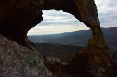
| Spectacular views - through the eye of the Sphinx |
 |
| Arkansas Sphinx |
 |
| Parking Location #1 Note the two trees with an "S" marking the trail. |
After coming down the trail to parking location #1, I hiked along CR-4840 and then back up Highway 123 to where I had parked the FJ Cruiser at parking location #2. Even with this additional distance, I only hiked a total of 2.7 miles. I would rate this as a moderate hike only due to the steepness of the trail, no matter which route you take to get there. The trails in both routes are in fairly good condition, so hikers of all ages should be able to do this hike if they can make the climb.
 |
| Blue - Route #1 to Arkansas Sphinx Red - Route #2 to Arkansas Sphinx |
I also suggest you reed this guide Rick: http://www.travelindependent.info/what-to-pack-travel.htm
ReplyDeleteYou really need the help.
Thanks, man. I clearly need all the help I can get.
DeleteI really enjoyed you blog.
ReplyDelete