GPS Coordinates:
Parking - 35.56779, -93.06633
Cabin Falls - 35.56936, -93.06311
Maidenhair Falls - 35.56613, -93.06165
Juncture of Creeks - 35.56798, -93.05984
Pet friendly: Iffy. OK for pets off leash, pets on leash would be extremely difficult due to the amount of undergrowth and rough terrain.
Motorcycle friendly: Motorcycle friendly: Yes. Just pull off Hwy 7 and park.
GPS Files (.gpx format):
Cabin Falls and Maidenhair Falls track
My wife (my normal hiking partner and trip photographer, as well as the love of my life) and I are always joking about all the waterfalls, crags, caves and other nature offerings of the Ozarks that are practically in our own backyard, and for the first 22 years we lived here we had little or no clue of their existence. This trip certainly shows that to be true. These falls are literally only 15 miles from our front door, and right off Hwy 7. Two months ago, I had never even heard of them. After seeing them in Tim Ernst's waterfalls book, I could find nothing in internet searches on these falls, so I decided I had to go take a look.
To get there, go north on Hwy 7 from Dover until you pass Mack's Pines. Note your odometer and 1.1 miles from Mack's Pines, park on the right under the power lines. From there, hike north under the power lines until you get to the bottom of the hill. You will see a culvert deep under Hwy 7 that is actually the top of the Cabin Falls Creek drainage system. Turn right here and follow the creek downhill. I don't think this creek has a name, but I'll call it Cabin Falls Creek for obvious reasons. There is a spring close to the highway that feeds the creek.
 Follow the creek downstream on the left (north) bank. a trace of an old road is barely visible and you can follow that downhill. Right away you will start to see some smaller waterfalls on the creek. This area is riddled with layers of limestone that make for numerous points in the creeks where water runs off a rock shelf and forms a waterfall. As you go down the creek, you from one to the next, to the next. So many that I lost count. As far as I know, only Cabin Falls and Maidenhair Falls are named, although many of the others are of significant size and beauty.
The geology of the area makes for a very waterfall-rich area, but it also makes for very steep slopes as the creeks have eaten their way through the rock forming their valleys. This means that where there is a good sized waterfall, there is also probably a cliff to the creek bed below. So if you are like me and like to get to the base of waterfalls, you will have to find a way down to the creek bed below. In the hollows of this drainage system, that is not always easy. OK, let's say rarely easy.
 Going down Cabin Falls Creek, I passed a nice waterfall upstream from Cabin Falls. Trying to get to the creek bed below, I soon found out that you really need to be on the right (south) side of the creek to find a way down. Going back upstream and crossing the creek also gives you the opportunity to see another nice waterfall in a small creek running into Cabin Falls Creek from the south.

Follow the bluff line south, around from Cabin Falls, and you go by the gap in the bluff cliff in this photo that will give you a way to hike down.
Once you get down below this bluff line, you can continue on south to the feeder creek and a nice waterfall on it. Then follow that creek back around to Cabin Falls Creek, and you will come to another bluff to Cabin Falls' grotto, then make your way down with yet another waterfall in yet another grotto where the feeder creek runs into Cabin Falls Creek. In fact, both the feeder creek and Cabin Falls Creek have waterfalls where they flow into this grotto. When I said "waterfall rich area", I meant that literally. Cabin Falls itself falls 36 feet into the beautiful grotto below.
 Going downstream from Cabin Falls, you come to another falls, and another, and another...
 And yet another. Eventually the creek actually levels out a little from the steep slope it has had thus far. Get on the right (south) side, and you can follow the old trace road again here until you come to Maidenhair Falls Creek. I followed this combined creek just a short distance more and came to a creek feeding in from the north side with a pretty little waterfall, a cave, and yet another waterfall downstream.


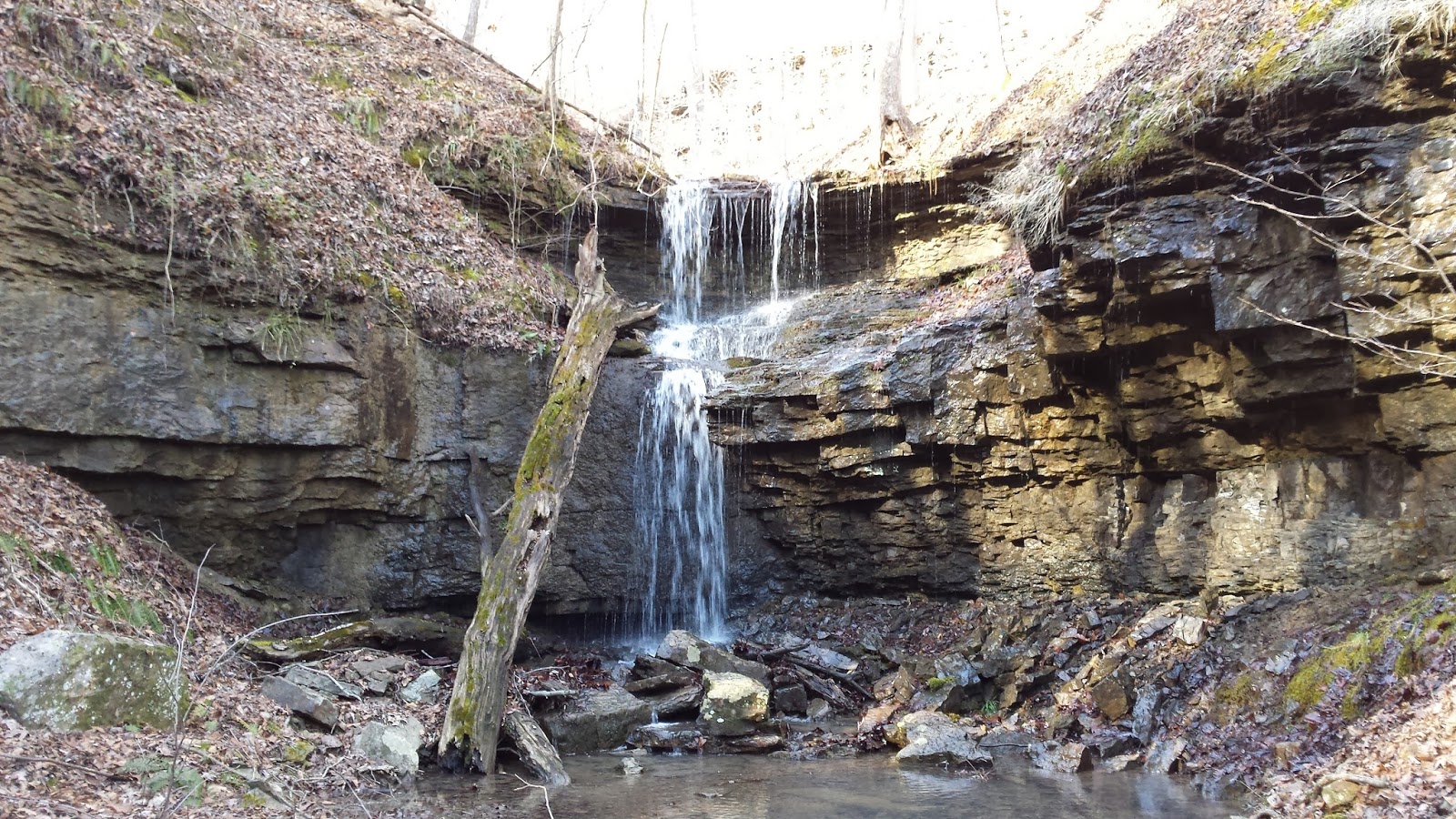
 |
| Cabin Falls |
To get there, go north on Hwy 7 from Dover until you pass Mack's Pines. Note your odometer and 1.1 miles from Mack's Pines, park on the right under the power lines. From there, hike north under the power lines until you get to the bottom of the hill. You will see a culvert deep under Hwy 7 that is actually the top of the Cabin Falls Creek drainage system. Turn right here and follow the creek downhill. I don't think this creek has a name, but I'll call it Cabin Falls Creek for obvious reasons. There is a spring close to the highway that feeds the creek.
Follow the creek downstream on the left (north) bank. a trace of an old road is barely visible and you can follow that downhill. Right away you will start to see some smaller waterfalls on the creek. This area is riddled with layers of limestone that make for numerous points in the creeks where water runs off a rock shelf and forms a waterfall. As you go down the creek, you from one to the next, to the next. So many that I lost count. As far as I know, only Cabin Falls and Maidenhair Falls are named, although many of the others are of significant size and beauty. The geology of the area makes for a very waterfall-rich area, but it also makes for very steep slopes as the creeks have eaten their way through the rock forming their valleys. This means that where there is a good sized waterfall, there is also probably a cliff to the creek bed below. So if you are like me and like to get to the base of waterfalls, you will have to find a way down to the creek bed below. In the hollows of this drainage system, that is not always easy. OK, let's say rarely easy.
Going down Cabin Falls Creek, I passed a nice waterfall upstream from Cabin Falls. Trying to get to the creek bed below, I soon found out that you really need to be on the right (south) side of the creek to find a way down. Going back upstream and crossing the creek also gives you the opportunity to see another nice waterfall in a small creek running into Cabin Falls Creek from the south. Follow the bluff line south, around from Cabin Falls, and you go by the gap in the bluff cliff in this photo that will give you a way to hike down.
Once you get down below this bluff line, you can continue on south to the feeder creek and a nice waterfall on it. Then follow that creek back around to Cabin Falls Creek, and you will come to another bluff to Cabin Falls' grotto, then make your way down with yet another waterfall in yet another grotto where the feeder creek runs into Cabin Falls Creek. In fact, both the feeder creek and Cabin Falls Creek have waterfalls where they flow into this grotto. When I said "waterfall rich area", I meant that literally. Cabin Falls itself falls 36 feet into the beautiful grotto below.
 |
| Cabin Falls Grotto |
This waterfall flows into an emerald pool just before flowing into Cabin Falls Creek. I don't doubt there are more waterfalls up this tributary, but I did not have time this trip to explore further. Downstream further a mile or so the creek from Winter Hollow also flows into this creek. It is said to have several waterfalls, and due to it's remoteness I doubt many have been visited them in modern times.
.
.
Heading back, I stayed at creek level and saw what I missed by crossing Maidenhair Falls Creek a little higher on my way downstream. This double stairstep waterfall is at the juncture of Cabin Falls Creek and Maidenhair Falls Creek. The GPS coordinates for this juncture are at the top of this post. I turned left here and started following Maidenhead Falls upstream.
Picking my way upstream on the Maidenhair Falls Creek drainage, I came upon this waterfall. This was another one of those grottos with no good way upstream unless you backtrack a good ways to get up on the bluff line. I decided the best way forward was to climb up the falls itself, where there were a lot of rock ledges that could be stepped on to climb up. Yes, I am that stupid. Fortunately, I did manage it just fine and got to the top of this falls with no slips and broken bones.
 |
| Maidenhair Falls |
Continuing upstream, I finally arrived at Maidenhair Falls, the last stop on this hiking loop. This is a beautiful 30 foot waterfall. Unfortunately, it was partially obscured today by a large tree that had fallen right across the top of the falls.
From here, I had to backtrack a little to get to a spot I had scoped out on the way upstream where i could climb the north canyon wall. The north creek wall here is very steep. Loose leaves and soft soil make it a little hard to get good footing, and it is a several hundred foot climb back up to the top of the ridge. You do need to go out on the right side as you are facing upstream (north side). The parking location on Hwy 7 will be less than a half mile northwest of Maidenhair Falls. Mostly up, it seemed. I plan on analyzing my track from this hike and my next visit here I may reverse direction and do a descent to Maidenhair Falls and a not so steep ascent back to Cabin Falls.
The only place that had any significant undergrowth was on the upper part of the mountain above Maidenhair falls. The rest of the hike was easier bushwhacking, but this was pretty thick. I ran into another old trace road and followed this back to Hwy 7. The trace road brought me back to Hwy 7 just 220 feet south of where I had parked.
This was a very enjoyable hike. It seemed I had been out enjoying the area all afternoon, but it was only a total of two and a half hours from parking to heading back home. If you live in the River Valley and are looking for great place to explore nearby and enjoy the Natural State's wonders, this will fill the bill nicely. It will help to have a GPS and a good sense of balance - be careful as there are many, many dropoffs and steep slopes.
 |
| GPS Track for Cabin and Maidenhair Falls Loop |
Do you have the GPX file for this? Thanks!
ReplyDeleteAdded it to the blog! Check it out.
Delete